Search the Special Collections and Archives Portal

Search Results

Displaying results 11461 - 11470 of 19618

Blueprints and Drawings, 1902-1975

Level of Description

Series

Scope and Contents

The Blueprints and Drawings series (1902-1975) contain drawings and maps of railroad buildings including depots in Nevada, Utah, and California; employee cottages, houses, and hospitals; and other railroad operational buildings, maps, and surveys. Also included are drawings of plats of track, right of way, elevation, easements, highways and roads, water facilities, and pipelines. The types of drawings include blueprints, blue-line, brown-line, tracing paper, vellum, mylar, and linen. Architectural drawings include site plans, floor plans, elevations, roof plans, sections, and schematic details. Structural drawings include foundation details, framing plans, and structural connection details. Mechanical drawings include plans detailing air conditioning ductwork and machinery schematics.

This series also contains sets of original drawings by architect Gilbert Stanley Underwood for the lodges and other park buildings at the Southern Utah National Parks at Zion, Bryce Canyon, Cedar Breaks, and the North Rim of the Grand Canyon constructed between 1924 and 1928 by the Union Pacific Railroad and the National Park Service to develop resort facilities to enhance tourism and the railroad's passenger service.

Archival Collection

Union Pacific Railroad Collection
To request this item in person:
Collection Number: MS-00397
Collection Name: Union Pacific Railroad Collection
Box/Folder: N/A

Archival Component

4 Mile Bar Neon Survey document, September 8, 2017

Date

2017-09-08

Description

Information about the 4 Mile Bar sign that sits at 3650 Boulder Hwy.
Site name: 4 Mile Bar (Las Vegas, Nev.)
Site address: 3650 Boulder Hwy
Sign owner: Bob and Bill Joslin
Sign details: This is one of the most historic bars in Las Vegas. The original site of the bar was actually where one of the oldest communities in town began called Formyle. The community was there long before The Boulder Highway or US Highway 95. The area where the bar currently resides was called Four Mile Spring because it was "four miles from the center of town" and for the natural spring that was there. This part of town, for much of its history, was outside of Las Vegas city limits and outside of the laws for the rest of the city as well. This site was originally a brothel when it opened in the 1950s. In 1954, the property was raided by the FBI and then ended up turning into a bar. It is "one of the Valley's last true-blue roadhouses" and it is named because it sits four miles away from the Downtown area. They are also known for their very popular karaoke nights.
Sign condition: 4, the roadside sign is in good condition, but the sign that is attached to the building has some light bulbs that have been burned out on it.
Sign form: Roadside sign is a pole sign with a message center and there is an architectural sign attached to the facade of the building.
Sign-specific description: The road side portion of the signage for the 4 Mile Bar is fairly simple. The top of the sign features a plastic, backlit square that has a large red "4" and "MILE" in bold white text in the middle of the number. Underneath this is "BAR" in a bold red text against a white background. About a foot or two underneath this sign is a large plastic, backlit reader board. The main support for the sign is a white rectangular structure with two red stripes running down the center of it with a few inches of space between the lines. The architectural sign that is on the facade of the building is uncomplicated as well. The shape of it fits the top portion of the building and looks like a stretched out rectangle. All of the edges are lined by incandescent light bulbs. In the middle of the sign in open channel letters are the words "4 MILE BAR" that are filled with white glowing neon tubes.
Sign - type of display: Incandescent, neon and backlit plastic portion
Sign - media: Steel and plastic
Sign - non-neon treatments: Plastic
Sign environment: This bar sits at the cusp where Fremont Street transitions to Boulder Highway. Many of the immediate properties that sit near this bar are motels and mobile home communities. This is also just down the road from Boulder Station Hotel and Casino as well as the Winchester Cultural Center.
Sign - thematic influences: The roadside sign is very straightforward since it just displays the name of the bar, but there could have been a stylistic choice to use the actual number "4" instead of the word "four."
Sign - artistic significance: The most notable feature about this sign is the number "4" instead of the word "four" that is used, possibly for stylistic reasons.
Survey - research locations: Accessor's Page http://www.clarkcountynv.gov/assessor/Pages/searchbybusinessname.aspx, Review Journal articles https://storify.com/ReviewJournal/7-of-the-most-historic-bars-in-las-vegas and https://www.reviewjournal.com/uncategorized/over-a-century-four-mile-has-gone-from-trailside-oasis-to-brothel-to-bar/ , Vegas Seven article http://vegasseven.com/2013/06/12/las-vegas-bar-hall-fame/
Surveyor: Lauren Vaccaro
Survey - date completed: 2017-09-08
Sign keywords: Architectural; Incandescent; Neon; Backlit; Plastic; Steel; Pole sign; Roadside

Text

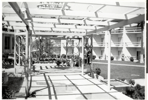
Photograph of a covered walkway in the Tropicana courtyard (Las Vegas), 1957

Date

1957

Description

A covered walkway in the courtyard area of the Tropicana Hotel in 1957.
Site Name: Tropicana Hotel
Address: 3801 Las Vegas Boulevard South, Las Vegas, NV

Image
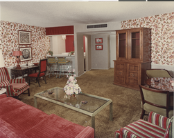
Photograph of a suite at the Frontier Hotel (Las Vegas), 1970s

Date

1970 to 1979

Description

View of a suite at the Frontier Hotel. Stamp on back of photo: "Allen photographers."
Site Name: Frontier
Address: 3120 Las Vegas Boulevard South

Image
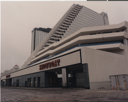
Photograph of the front entrance of the Showboat Hotel and Casino (Atlantic City), 1987

Date

1987

Description

Front entrance to the Showboat Hotel and Casino in Atlantic City.
Site Name: Showboat Hotel and Casino (Atlantic City)
Address: 801 Boardwalk, Atlantic City, NJ

Image
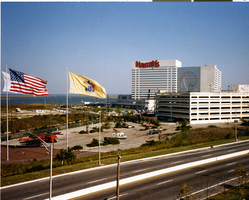
Photograph of Harrah's Marina Resort, Atlantic City, circa 1980

Date

1978 to 1982

Description

Exterior view of Harrah's Resort in Atlantic City.
Site Name: Harrah's Marina Resort (Atlantic City)
Address: 777 Harrah's Boulevard, Atlantic City, NJ

Image
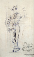
Scale drawing of Vegas Vic, 1951

Date

1951

Description

Annotated scale drawing of Vegas Vic for the Pioneer Club in Las Vegas with measurement grid.
Site Name: Pioneer Club
Address: 25 East Fremont Street

Image
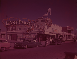
Film transparency of the entrance to the Last Frontier Village (Las Vegas), circa 1950s

Date

1950 to 1959

Archival Collection

Description

Front entrance to the Last Frontier Village. The Silver Slipper Gambling Hall is seen in the foreground.
Site Name: Frontier
Address: 3120 Las Vegas Boulevard South

Image