Search Results
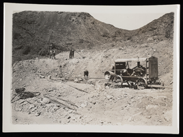
Photograph of substation site, Hoover Dam, circa 1932
Date
1931 to 1933
Archival Collection
Description
Building site of sub station. Air compressor on right; tripod w/large jackhammer, upper left, to drill holes. Note on back: "Air compressor used on railroad grade by Lewis Construction."
Image
Site Selection and Master Plan, Vol. 1, 1980
Level of Description
File
Archival Collection
Thalia Dondero Political Papers
To request this item in person:
Collection Number: MS-00345
Collection Name: Thalia Dondero Political Papers
Box/Folder: Box 26
Collection Name: Thalia Dondero Political Papers
Box/Folder: Box 26
Archival Component
Nevada Test Site Service leaflet, undated
Level of Description
File
Archival Collection
Greenpeace Pacific Southwest Records
To request this item in person:
Collection Number: MS-00363
Collection Name: Greenpeace Pacific Southwest Records
Box/Folder: Box 02
Collection Name: Greenpeace Pacific Southwest Records
Box/Folder: Box 02
Archival Component
Guidelines for Nevada Test Site activities, undated
Level of Description
File
Archival Collection
Greenpeace Pacific Southwest Records
To request this item in person:
Collection Number: MS-00363
Collection Name: Greenpeace Pacific Southwest Records
Box/Folder: Box 02
Collection Name: Greenpeace Pacific Southwest Records
Box/Folder: Box 02
Archival Component
Map of Nevada Test Site security, undated
Level of Description
File
Archival Collection
Greenpeace Pacific Southwest Records
To request this item in person:
Collection Number: MS-00363
Collection Name: Greenpeace Pacific Southwest Records
Box/Folder: Box 02
Collection Name: Greenpeace Pacific Southwest Records
Box/Folder: Box 02
Archival Component
LDE X: Saturday Evening, Site Crossing, 1991
Level of Description
File
Archival Collection
Nevada Desert Experience Records
To request this item in person:
Collection Number: MS-00524
Collection Name: Nevada Desert Experience Records
Box/Folder: Box 15
Collection Name: Nevada Desert Experience Records
Box/Folder: Box 15
Archival Component
Nevada Test Site research, 1957-1971
Level of Description
File
Archival Collection
Perry Kaufman Papers
To request this item in person:
Collection Number: MS-00414
Collection Name: Perry Kaufman Papers
Box/Folder: Box 02
Collection Name: Perry Kaufman Papers
Box/Folder: Box 02
Archival Component
Nevada Test Site phone blockade, undated
Level of Description
File
Archival Collection
Greenpeace Pacific Southwest Records
To request this item in person:
Collection Number: MS-00363
Collection Name: Greenpeace Pacific Southwest Records
Box/Folder: Box 01
Collection Name: Greenpeace Pacific Southwest Records
Box/Folder: Box 01
Archival Component
#58930: Antenna Site, 1991 April 17
Level of Description
File
Archival Collection
University of Nevada, Las Vegas Creative Services Records (1990s)
To request this item in person:
Collection Number: PH-00388-03
Collection Name: University of Nevada, Las Vegas Creative Services Records (1990s)
Box/Folder: N/A
Collection Name: University of Nevada, Las Vegas Creative Services Records (1990s)
Box/Folder: N/A
Archival Component
Nevada Test Site by James P. Stacy, undated
Level of Description
Item
Archival Collection
Company Mobility Histories Papers
To request this item in person:
Collection Number: MS-00763
Collection Name: Company Mobility Histories Papers
Box/Folder: Box 02
Collection Name: Company Mobility Histories Papers
Box/Folder: Box 02
Archival Component