Search Results

Building 10: architectural and structural drawings; revisions, 1971 July
Level of Description
Scope and Contents
This set includes drawings for Little America Refining Co. (client).
This set includes: redlining, index sheet, site plan, foundation plans, framing plans, floor plans, roof plans, exterior elevations, interior elevations, wall sections, building sections, isometric construction details, construction details, and finish and door schedules.
Archival Collection
Collection Name: Martin Stern Architectural Records
Box/Folder: Roll 045
Archival Component
Freedom Train Motel, 1990 May 07; 1990 July 20
Level of Description
Scope and Contents
This set includes: redlining, index sheet, site plans, floor plans, exterior elevations, construction details, mechanical plans, electrical plans, plumbing plans, reflected ceiling plans, interior elevations, demolition plans and general specifications.
This set includes drawings for Oxford Technologies Inc (client) by Jett Engineers (engineer).
Archival Collection
Collection Name: Gary Guy Wilson Architectural Drawings
Box/Folder: Roll 188
Archival Component
Renaissance Center III: Cellular One Building: Owner Review, 1992 August 14
Level of Description
Scope and Contents
This set includes: index sheet, exterior elevations, finish/door/window schedules, general specifications, floor plans, roof plans, reflected ceiling plans, interior elevations, foundation plans, framing plans, building sections, construction details and site plans.
This set includes drawings for Vista Group, Inc (client).
Archival Collection
Collection Name: Gary Guy Wilson Architectural Drawings
Box/Folder: Roll 373
Archival Component
Drive Up Cleaners, 1977 August 28; 1977 October 06
Level of Description
Scope and Contents
This set includes: floor plans, foundation plans, roof plans, building sections, reflected ceiling plans, construction details, general specifications, finish/door schedules, electrical plans, electrical schematics, fixture schedules, HVAC plans, exterior elevations and site plans.
This set includes drawings for Henry L. Resnick (client).
Archival Collection
Collection Name: Gary Guy Wilson Architectural Drawings
Box/Folder: Roll 433
Archival Component
Empire Office Building, 1980 March 11
Level of Description
Scope and Contents
This set includes: index sheet, exterior perspective, site plans, floor plans, roof plans, exterior elevations, foundation plans, framing plans, reflected ceiling plans, building sections, construction details, interior elevations and finish/door/window schedules.
This set includes drawings for Empire Plaza General Partnership (client)
Archival Collection
Collection Name: Gary Guy Wilson Architectural Drawings
Box/Folder: Roll 170
Archival Component
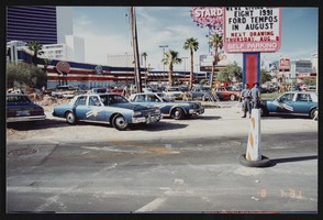
Photographs of Frontier Strike: line, police, media, Culinary Union, Las Vegas (Nev.), 1991 August (folder 1 of 1)
Date
Archival Collection
Description
Culinary Union workers strike at the Frontier Hotel and Casino in August of 1991. Strikers march holding protesting posters with the image of Margaret Elardi. The photos also show police officers and news reporters on site.Arrangement note: Series I. Demonstrations, Subseries I.A. Frontier Strike Site name: Frontier Hotel and Casino
Image
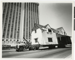
Photograph of Houssels House passing the Las Vegas Hilton, Las Vegas (Nev.), 1983
Date
Archival Collection
Description
Image
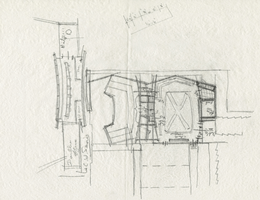
Architectural sketch of the Hacienda (Las Vegas), plot plan, 1951-1956
Date
Archival Collection
Description
Rough sketch of the plot of the proposed Lady Luck, later the Hacienda. Original medium: pencil on tracing paper.
Site Name: Hacienda
Address: 3590 Las Vegas Boulevard South
Image
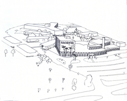
Architectural drawing of the Hacienda (Las Vegas), plot plan conceptual drawing, 1950-1955
Date
Archival Collection
Description
Conceptual drawing of the plot plan of the Hacienda from the early 1950s. Original medium: ink on tracing paper
Site Name: Hacienda
Address: 3590 Las Vegas Boulevard South
Image