Search Results
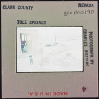
Photographic slide of cook shack, Tule Springs, Nevada, circa 1962-1963
Date
1962 (year approximate) to 1963 (year approximate)
Archival Collection
Description
An exterior view of the "cook shack" at Tule Springs camp site. A dog is standing near the door.
Image


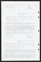

Air conditioning drawings, sheets AC100-AC303; plumbing drawings, sheets P100-P308, 1979 October 31
Level of Description
File
Scope and Contents
This set contains drawings for MGM Grand Hotel Inc. (client) and Taylor Construction (contractor) and includes drawings by William S. Petersen (engineer) and JBA (engineer).
This set includes: air conditioning plans, air condidtioning schedules, plumbing site plans, plumbing plans, plumbing fixture schedules, and plumbing schematics.
Archival Collection
Martin Stern Architectural Records
To request this item in person:
Collection Number: MS-00382
Collection Name: Martin Stern Architectural Records
Box/Folder: Roll 037
Collection Name: Martin Stern Architectural Records
Box/Folder: Roll 037
Archival Component