Search Results

Topographic map of the northeast quadrangle of the metropolitan Las Vegas, Nevada area, 1967
Date
Description
Image
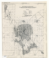
Map of part of Las Vegas Valley showing contours of the composite piezometric surface during the spring of 1944, and specific capacities of wells tapping the confined water
Date
Description
Relief shown by contours. Includes range and township grid. Shows springs and wells. Scale [ca. 1:67,162. 1 in. to approx. 1.06 miles]. Series: Water resources bulletin (Carson City, Nev.)
no. 5. Originally published as plate 8 in Geology and water resources of Las Vegas, Pahrump, and Indian Spring Valleys, Clark and Nye Counties, Nevada by George B. Maxey and C.H. Jameson, which is number 5 of the Water resources bulletin published by the Nevada Office of the State Engineer.
Image
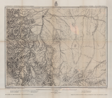
Map of part of central Colorado, May 7, 1877
Date
Description
38 x 48 cm. Relief shown by hachures and spot heights. "Atlas sheet no. 53(C)." "Issued May 7th 1877." "1st. Lieut. Geo. M. Wheeler, Corps of Engineers, U.S. Army." Prime meridians: Greenwich and Washington, D.C. Includes sectional diagram that shows how atlas sheets fit together. "Weyss, Herman & Lang, del." "Louis Nell, J. J. Young, topographical assistants." "Under the direction of Brig. General A. A. Hunphreys, Chief of Engineers, U. S. Army." "Expeditions of 1873 and 1876 under the command of 1st. Lieutenant William L. Marshall, Corps of Engineers, U. S. Army, 1st Lieutenant Eric Bergland, Corps of Engineers, U. S. Army, Executive Officers and field astronomers." "By order of the honorable the Secretary of War." Original publisher: Graphic Co. photo., Scale: 1 inch to 4 miles or 1:253440.
Image
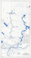
Map and operational diagram, lower Colorado River, Lees Ferry to Gulf of California, June 1973
Date
Description
Image
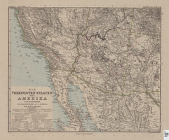
Map of Southwestern United States of America, 1888
Date
Description
Image

Plat of H.F.M & M addition to city of Las Vegas, Clark County, Nevada, comprising the west 1/2 of N.W. 1/4 Sec. 27, Twp. 20 S., R. 61 E., M.D.B & M, March 8, 1924
Date
Description
Image
Kirk Kerkorian oral history interview
Identifier
Abstract
Oral history interview with Kirk Kerkorian conducted by K.J. Evans on February 10, 1999 for the Las Vegas Review-Journal First 100 Oral History Project. In this interview Kirk Kerkorian discusses Howard Hughes and Jerry Williams and how they were two men who he respected and learned from. He also talks about how Jerry Williams introduced him to Las Vegas, Nevada. He then discusses how he was ecstatic when he saw Las Vegas for the first time and how he helped build Bally's, The International, and the MGM Grand Hotel.
Archival Collection
Eunice Claxton oral history interview
Identifier
Abstract
Eunice Claxton oral history interview conducted by Claytee White on June 4, 5, and 10, 2015 for African Americans in Las Vegas: a Collaborative Oral History Project. Claxton discusses living in Reno and Las Vegas, Nevada, attending the Westside School, working as shield in El Morocco nightclub, and memories of Jackson Street life.
Archival Collection
Louis Fisher oral history interview
Identifier
Abstract
Oral history interview with Louis Fisher conducted by Samuel Barto on March 20, 1978 for the Ralph Roske Oral History Project on Early Las Vegas. Fisher discusses the history of Las Vegas, Nevada from 1953 and offers insight into the rapid growth of Las Vegas with special focus on the Las Vegas Strip, banks, the steady influx of people moving to Las Vegas for the warm climate, and housing.
Archival Collection
International Center for Responsible Gaming Records [UNPROCESSED]
Identifier
Abstract
This collection is unprocessed. The International Center for Responsible Gaming Records [UNPROCESSED] (approximately 1995-2023) mostly consist of the organization's grant files. The records also include conference programs, promotional material, photographs, and educational videotapes produced by the organization.
Archival Collection