Search Results
Rex Bell and Rex Bell Jr.: photographic print
Date
1880 to 1979
Archival Collection
Description
Dorothy Bell Scans UNLV-Public Lands Institute
Image

Rex Bell with Rex Anthony Bell, Jr. as a child: photographic print
Date
1880 to 1979
Archival Collection
Description
Dorothy Bell Scans UNLV-Public Lands Institute.
Image

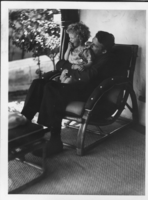
Rex Bell holding Rex Anthony Bell, Jr.: photographic print
Date
1934 (year approximate) to 1962 (year approximate)
Archival Collection
Description
Dorothy Bell Scans UNLV-Public Lands Institute
Image

Clara Bow holding Rex Anthony Bell, Jr., as an infant: photographic print
Date
1934 (year approximate) to 1935 (year approximate)
Archival Collection
Description
Dorothy Bell Scans UNLV-Public Lands Institute
Image

Clara Bow holding Rex Anthony Bell, Jr., as an infant: photographic print
Date
1934 (year approximate) to 1935 (year approximate)
Archival Collection
Description
Dorothy Bell Scans UNLV-Public Lands Institute
Image

Clara Bow holding Rex Anthony Bell, Jr., as an infant: photographic print
Date
1934 to 1965
Archival Collection
Description
Dorothy Bell Scans UNLV-Public Lands Institute
Image

Clara Bow holding Rex Anthony Bell, Jr., as an infant: photographic print
Date
1934 (year approximate) to 1935 (year approximate)
Archival Collection
Description
Dorothy Bell Scans UNLV-Public Lands Institute
Image

Clara Bow holding Rex Anthony Bell, Jr., as an infant: photographic print
Date
1934 (year approximate) to 1935 (year approximate)
Archival Collection
Description
Dorothy Bell Scans UNLV-Public Lands Institute
Image
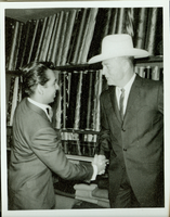
Rex Bell with an unidentified man: photographic print
Date
1880 to 1979
Archival Collection
Description
Dorothy Bell Scans UNLV-Public Lands Institute
Image

Map of California and Territories of New Mexico and Utah, 1862
Date
1862
Description
Scale [ca. 1:3,231,360. 1 in. to approx. 51 miles] (W 125°00--W 103°30/N 42°00--N 31°45) ; 1 map : hand col. ; 40 x 60 cm., on sheet 46 x 68 cm ; Relief indicated by hachures and spot heights ; Prime meridians: Greenwich and Washington, D.C ; Decorative border ; Hand colored ; Atlas p. numbers in upper margin: 58-59 ; Date est. from territorial borders and county configuration ; Shows natural features, locations of Indian tribes, proposed railroad routes, routes of explorers, trails, county boundaries and populated places ; Johnson and Ward
Image