Search Results
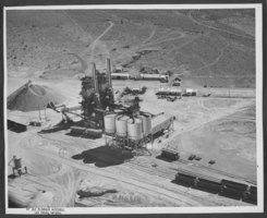
Aerial photograph of U.S. Lime Products Corporation, Apex, Nevada, circa 1963
Date
1962 to 1964
Archival Collection
Description
Aerial view of U.S. Lime Products Corporation in Apex, Nevada, showing six silos and a kiln.
Image

Aerial photograph of downtown Las Vegas, Nevada, circa 1963
Date
1962 to 1964
Archival Collection
Description
Aerial photograph of downtown Las Vegas, Nevada looking northeast towards Frenchman and Sunrise Mountains. The Overland Hotel, Golden Gate, Silver Palace, Hotel Fremont, The Mint, Silver Palace, Las Vegas Club, and Horseshoe Club on Fremont Street are visible in the center. The Union Pacific Railroad Station (curved Art Deco building) and tracks are in the bottom left of photo.
Image
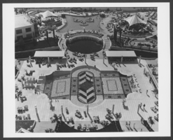
Aerial photograph of swimming pools at Caesars Palace, Las Vegas, Nevada, circa 1970s-1980s
Date
1970 to 1989
Archival Collection
Description
Aerial view of swimming pool and patio area at Caesars Palace, Las Vegas, Nevada.
Image

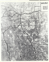
Photograph of the famous map of Bullfrog Mining District, Beatty, Nevada, circa 1950s
Date
1950 to 1959
Archival Collection
Description
The famous map of Bullfrog Mining District, designed by T.G. Nicklin, editor Of the Bullfrog Miner, Beatty, Nevada, shortly after the founding of the town of Beatty. This particular copy was distributed by the Exchange Club, probably During the 1950s. The town of Beatty is featured at the Bullfrog's heart. (Courtesy of Claudia Reidhead, Beatty, Nevada.) The Bullfrog Miner was published betweeen April 8, 1905-July 1909.
Image
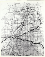
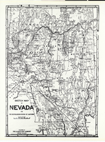
Photograph of a portion of a map of the state of Nevada, 1906
Date
1906
Archival Collection
Description
A portion of a map of the state of Nevada published by the Clason Map Co., Denver, Colorado, copyrighted 1906. Note the routes of the railroads in the southern Nevada area, including the Las Vegas and Tonopah Railroad linking the small community of Las Vegas with Beatty; (More information on the map is contained on the photo board.) (Courtesy, Central Nevada Museum, Tonopah, Nevada.)
Image
Photograph of a portion of a map of Southern California, circa 1920s
Date
1920 to 1929
Archival Collection
Description
A portion of a map produced by the Automobile Club of Southern California During the early 1920s. The map was of San Bernardino County, California; this portion of the map shows roads and railroads and communities in the Barstow, California, area. Of particular interest is the railroad linking Tonopah and Tide Water Railroad with the Santa Fe tracks at Ludlow, California, and the stops on the T&T between Ludlow and Riggs, north of Silver Lake, California. (Courtesy of Claudia Reidhead, Beatty, Nevada.)
Image
Photograph of a sketch map of Nevada and a portion of Southeastern California, 1906
Date
1906
Archival Collection
Description
A map of Southern California and Southwestern Nevada prepared by the map department of the Automobile Club of Southern California, 1906. This map shows the development of roads, railroads, and communites in the Southcentral Nevada and Death Valley areas. This map seems to be identical to that pictured in 0734 of this collection, although this photograph provides more Coverage of the Mojave Desert area. Note the many springs listed in the south Central Nevada area. (Courtesy of Claudia Reidhead, Beatty, Nevada.)
Image

Photograph of a portion of a map of the state of California, circa 1920s
Date
1920 to 1929
Archival Collection
Description
A portion of a map of the state of California produced by the Automobile Club Of Southern California, early 1920s. This portion provides a view of the major roads in the Beatty-Pahrump region of Nevada. (Courtesy of Claudia Reidhead, Beatty, Nevada.)
Image
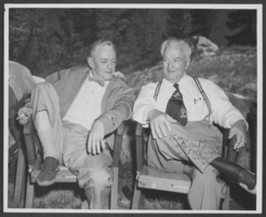
Photograph of Senator Pat McCarran and Harold Stocker, Las Vegas, circa 1933-1950s
Date
1933 to 1954
Archival Collection
Description
Pat McCarran with Harold Stocker in Las Vegas, Nevada Ca. 1933-1954. The photo is signed, "To my friend Harold Stocker with best wishes, Pat McCarran, U.S. Sentor, Nev."
Image
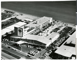
Photograph of the Thunderbird Motel, Miami Beach, Florida, circa 1950s-1960s
Date
1950 to 1969
Archival Collection
Description
The Thunderbird Motel, Miami Beach, Florida, circa 1950s-1960s. Rudma Picture Co. 1810 Ponce de Leon Blvd. Coral Gables, Florida.
Image