Search Results

Photograph of people at Charleston Peak (Nev.), 1910-1925
Date
1910 to 1925
Archival Collection
Description
Group poses in front of a log cabin at Charleston Peak. Identified from left to right: "1. Hazel Copper, 2. Jack Price, 3. unidentified 4. Leva Beckley, 5. Walter Bracken, 6. Bess Lightfoot, 7. Ruth Ferron, 8. Alta Ham. Child: Virginia Beckley."
Image
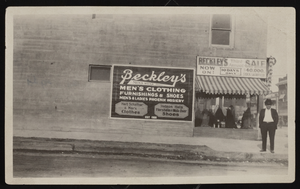
Exterior of Beckley's Men's Store, Las Vegas (Nev.), circa 1915
Date
1914 to 1916
Archival Collection
Description
Exterior of Beckley's Men's Store. Sign reads "Beckley's Men's Wear. Men's Clothing. Furnishings & Shoes. Mens &Ladies Phoenix Hosiery. Hart Schaffner & Marx Clothes. Stetson Hats Florsheim & Walk-Over Shoes. Est. 1908" and "Beckley's Third Annual Sale Now On: 10 Days Only $40,000 Stock Sacrificed"
Image
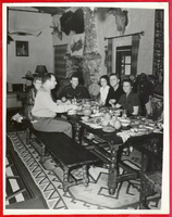
Group seated at the dining room table at Walking Box Ranch with Rex Bell at end of table: photograph
Date
1930 to 1945
Archival Collection
Description
From the Walking Box Ranch Photograph Collection (PH-00346). Rex Bell is at the end of the table.
Image
Audio recording clip of interview with Zenna Mae and Eugene Bridges by Mary Palevsky, November 19, 2004
Date
2004-11-19
Archival Collection
Description
Narrator affiliation: Downwinder (Salt Lake City, Utah)
Sound
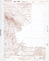
Map of Ely Range Quadrangle, Lincoln County, Nevada, 1921
Date
1921
Description
'Edition of 1921.' 'W. H. Herron, Acting Chief Geographer; Geo. R. Davis, Geographer In Charge; Topography by H. H. Hodgeson, N. E. Ballmer, and W. B. Upton, Jr.; Control by H. H. Hodgeson, Roscoe Reeves, and D. S. Birkett. Surveyed in 1916.' At top of map: ' Topography, State of Nevada.' At upper left corner: ' Department of the Interior, Albert B. Fall, Secretary; U.S. Geological Survey, George Otis Smith, Director.' Southern Nevada Mining Map Collection. 15 minute series (topographic) Nevada.
Image
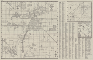
Map of Las Vegas and vicinity, including Henderson and Boulder City, Nevada, 1958
Date
1958
Description
53 x 52 cm. on sheet 56 x 87 cm. Includes inset maps of Boulder City, Henderson, Nellis Air Force Base and Las Vegas area. Map was probably published in 1958 because it shows the Stardust Hotel and Casino, which opened in 1958, but not the Convention Center, which opened in 1959. Includes index. Original publisher: Map Corporation of America.
Image
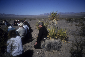
Slide of protesters at a demonstration near the Nevada Test Site, March 8, 1991
Date
1988 to 1991
Archival Collection
Description
Color image of people involved with the Lenten Desert Experience (also called the Nevada Desert Experience), a group demonstrating against nuclear testing, gathered in the Nevada desert.
Image
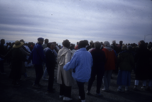
Slide of protesters holding hands at a demonstration near the Nevada Test Site, March 10, 1991
Date
1991-03-10
Archival Collection
Description
Color image of protesters holding hands at a Park-n-Ride lot preparing for an anti-nuclear testing demonstration organized by Lenten Desert Experience (also called Nevada Desert Experience) in the Nevada desert.
Image
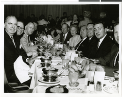
Photograph of the Ford Western Region Marketing group at the Sands Hotel, Las Vegas, circa 1965-1966
Date
1965 to 1966
Archival Collection
Description
An unidentified group of individuals from the Ford Western Region Marketing group at a dinner and show in the Copa Room at the Sands Hotel located in Las Vegas, Nevada.
Image
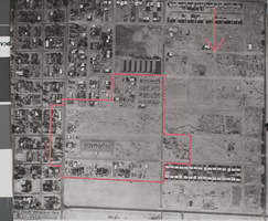
Photograph of the area projected for the building of the Madison School, Las Vegas, Nevada, 1957
Date
1957
Archival Collection
Description
An aerial photograph of the area projected for the building of the Madison School. The red dotted lines show the project boundaries. The photograph was taken by Henry Elder, City Building Inspector. Submitted to the Urban Renewal Administration Housing and Home Finance Agency by the City of Las Vegas, Project No. Nevada R-6.
Image