Search the Special Collections and Archives Portal
Search Results
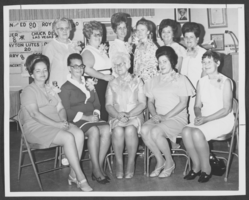
Photograph North Las Vegas Women of the Moose officers, June 15, 1972
Date
1972-06-15
Archival Collection
Description
Description provided with image: "North Las Vegas Moose women installed (new officers of Women of the Moose)-6/15/72. Seated, left, are Helen Woodington, Guide; Charlene Stamper, Assistant Guide; Dorothy Blosser, Pianist; Frances Demars, Sentinel; Ethel Myers, Argus. Standing, from left, Helen Shepherd, Treasurer; Mary Ann Williams, Junior Regent; Clara Compton, Senior Regent; Barbara Lefler, Junior. Graduate Regent; Jennie Nasabroad, Chaplain; and Clarice Barnum, Recorder."
Image
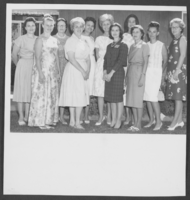
Photograph of North Las Vegas Women's Club luncheon, September 1964
Date
1964-09
Archival Collection
Description
Description provided with image: "North Las Vegas Women's Club welcomes eight guests and two new members at its first fall luncheon. (September 1964) Left to right: Evelyn Beard, Bev [Forson], Arlene Strahan, Marge Roach, Helen Askew, Alice Weiss, Judy [Ciliax], Kay Dietmier, Mrs. Mickey Johnson, Bell (Joie) Sanchez, Bernice [Houle]."
Image
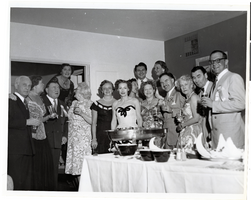
Photograph of Liberace, Tommy and Helen McGinty and guests at the Desert Inn's first anniversary party, Desert Inn, Las Vegas, Nevada, April 1951
Date
1951-04
Archival Collection
Description
Tommy and Helen McGinty (third and fourth from left), Liberace (back-center), Toni Clark (in front of Liberace) and unidentified guests at a buffet able at the Desert Inn's first anniversary party in Las Vegas, Nevada.
Image
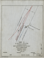
Map to accompany water contract, W. S. Cropper, Arden, Nevada, September 1919
Date
1919-09
Archival Collection
Description
'Exhibit A. L.A. & S.L. R.R. Co., Los Angeles Division. Sept. 1919. 'Approved [signed] C.F. Miller, Div. Engr.' 'I-W-68' hand-printed in lower right corner. 'Audit No 3114" hand-printed in lower left margin. Scale 1 in. = 100 ft.
Image
Map showing water pipeline in Clark Street, Las Vegas, Nev., August 1919
Date
1919-08
Archival Collection
Description
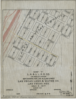
'Exhibit A. L.A & S.L. R.R. Co., Los Angeles Division.' ' Las Vegas Land & Water Co., Las Vegas, Nev.' 'August 1919' (?) 'Approved [signed] C.F. Miller Div. Engr. '2-W-18.' Handwritten in lower left margin: 'Audit No.1987A. Expires 12/31/23.' Pipeline marked in yellow. Area of Las Vegas in map labeled as 'Clark's Las Vegas Townsite.' Scale: 1 in. = 400 ft.
Image

Map showing water connection for Moapa School District No. 17, Moapa, Nevada, August 1920
Date
1920-08
Archival Collection
Description
'Exhibit A.' 'L.A. & S.L. R.R. Co., Los Angeles Division.' 'August 1920.' 'Approved, [signed] C.F. Miller, Div. Engr.' '2-W-49' hand-printed in lower right corner.'Audit # 3309 12/31/24" hand-printed in lower left margin. Scale: 1 in. = 100 ft
Image
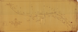
Map showing location of the Las Vegas & Tonopah Railroad from Las Vegas to Bullfrog, Nevada, 1906
Date
1906
Archival Collection
Description
'Office of Chief Engineer' printed on map above date.
Image

Las Vegas Valley map, Clark County, Nevada, June 1958
Date
1958
Description
'Compiled 1954. First revision - June 1958.' 'Area extends 9 miles north, 11 miles south, and 3 miles east, 3 miles west city limits of Las Vegas.' Original publisher: Campbell Realty. Scale [ca. 1:60,000. 1 in. to approx. 5,000 ft.]. Cadastral map. Hand-drawn red line around some sections on map.
Image
Photograph of a house in West Las Vegas, located adjacent to the North Project Boundary, Las Vegas, Nevada, October, 1957
Date
1957-10
Archival Collection
Description
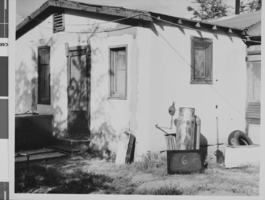
A house in West Las Vegas adjacent to the North Project Boundary. A sign leaning against a metal tank next to the house has the number "6" on it. The photograph was taken by Henry Elder, City Building Inspector, October, 1957. Refer to photo #0310 0058 (pho017999) for an aerial view of the area.
Image
Photograph of a shack house in West Las Vegas, located at 711 Van Buren Avenue, Las Vegas, Nevada, October, 1957
Date
1957-10
Archival Collection
Description
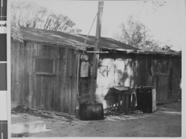
A shack house in West Las Vegas, located at 711 Van Buren Avenue (south side, in a trailer park). A sign leaning against the building has the the numbers "P-5" and R-107" on it. The photograph was taken by Henry Elder, City Building Inspector, October, 1957. Refer to photo #0310 0058 (pho017999) for an aerial view of the area.
Image
Pagination
Refine my results
Content Type
Creator or Contributor
Subject
Archival Collection
Digital Project
Resource Type
Year
Material Type
Place
Language
Records Classification
