Search Results

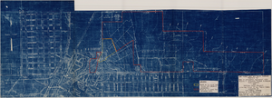
Map showing plan for water quality management update for wastewater collection systems in the Las Vegas Valley, February 20, 1997
Date
Description
Image
Map to accompany agreement with Willie T. Stewart, Vernon E. Bunker, Earl Leavitt and William Udell Stewart covering lease of Las Vegas Ranch property at Las Vegas, Nevada, January 31, 1951
Date
Archival Collection
Description
Image
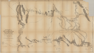
Map based on reconnaissance of the Zuñi, Little Colorado and Colorado Rivers in 1851 by U.S. Corps of Topographical Engineers
Date
Description
Image
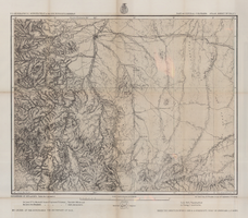
Map of part of central Colorado, May 7, 1877
Date
Description
38 x 48 cm. Relief shown by hachures and spot heights. "Atlas sheet no. 53(C)." "Issued May 7th 1877." "1st. Lieut. Geo. M. Wheeler, Corps of Engineers, U.S. Army." Prime meridians: Greenwich and Washington, D.C. Includes sectional diagram that shows how atlas sheets fit together. "Weyss, Herman & Lang, del." "Louis Nell, J. J. Young, topographical assistants." "Under the direction of Brig. General A. A. Hunphreys, Chief of Engineers, U. S. Army." "Expeditions of 1873 and 1876 under the command of 1st. Lieutenant William L. Marshall, Corps of Engineers, U. S. Army, 1st Lieutenant Eric Bergland, Corps of Engineers, U. S. Army, Executive Officers and field astronomers." "By order of the honorable the Secretary of War." Original publisher: Graphic Co. photo., Scale: 1 inch to 4 miles or 1:253440.
Image

General geologic map of Las Vegas, Pahrump, and Indian Spring Valleys, Clark and Nye Counties, Nevada, 1948
Date
Description
At top of map: 'United States Department of the Interior, Geological Survey. State Engineer of Nevada. Water resources bulletin No. 5, Plate 1.' Relief shown by spot heights. Includes 3 inset maps of wells and springs in the vicinity of Pahrump, Manse Ranch and Indian Springs, Nevada. Scale [ca. 1:126,720. 1 inch to approx. 2 miles] (W 116°--W 115°/N 40°--N 36°). Originally published as plate 1 in Geology and water resources of Las Vegas, Pahrump, and Indian Spring Valleys, Clark and Nye Counties, Nevada by George B. Maxey and C.H. Jameson (1948), which is number 5 of the Water resources bulletin published by the Nevada Office of the State Engineer.
Image

Topographic map of the Las Vegas Valley area, 1959
Date
Description
Image

Map of Boulder Dam area and Las Vegas, Nevada, October 7, 1930
Date
Description
Text
Brookman, Eileen
Eileen (Milstein) Brookman (1921-2004) was member of the Nevada Assembly from 1967-1977 and 1987-1990. Small in stature but nicknamed "Queenie" by her admirers, she advocated passionately for the rights of persons with disabilities, minorities, people with low incomes, women, and especially the elderly. Brookman entered state politics in 1962 when she was appointed Indian Commissioner by Governor Grant Sawyer.
Person
Dungan, Flora
Flora (Turchinsky) Dungan (1917-1973) was a Nevada Assemblywoman and University Regent who successfully sued the state of Nevada twice in order to gain additional representation for Clark County in the legislature and the Board of Regents (the governing board of the state's university system). As a result of Dungan v. Sawyer in 1964, seats were reapportioned in the Nevada legislature and Clark County gained four seats in the Assembly and seven in the Senate. After Dungan sued Nevada again in 1967, Clark County gained the majority of seats on the Board of Regents.
Person