Search Results
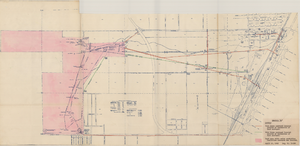
Map of Las Vegas Valley Water District, April 16, 1953
Date
1953-04-16
Archival Collection
Description
'Exhibit A.' 'April 16, 1953. Dwg, No. I-128.' Accompanies: Bill of Sale - LA&SL L.S.D. Audit No. 5251, Contract Dept. No. 39722-3 (Box 25 Folder 80-12).
Image
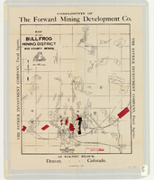
Map of the Bullfrog Mining District, Nye County, Nevada, circa 1905
Date
1901 to 1909
Description
At top of map: 'Compliments of the Forward Mining Development Co.' On left and right margins: 'The Patrick Investment Company, Fiscal Agents.' At bottom of map: '19 Toltec Block, Denver, Colorado.' 'The Williamson-Haffner Co., Denver.' Relief shown by hachures. Properties owned by Patrick Investment Company are marked in red. Shows railroads, roads, and pipelines. Scale [ca. 1:39,000. 1 in. to approx. 3,250 feet].
Image
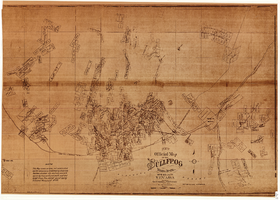
Map of the Bullfrog Mining District, Nye County, Nevada, circa 1905
Date
1901 to 1909
Description
'Compiled by Geo. E. Sherer and W.B. Milliken, miners and surveyors, Bull Frog, Nye Co., Nevada.' 'Photo. Lith. Britton & Rey, S.F.' Scale [ca. 1:16,800. 1 inch to approximately 1,400 feet]. Blueline print.
Image
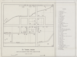
Map of St. Thomas, Nevada, circa 1933
Date
1930 to 1933
Archival Collection
Description
Hand-drawn map of St. Thomas, Nevada (ca. 1914-1932) which was abandoned in 1933 due to the construction of Hoover Dam and is now covered by Lake Mead, as remembered by Merle Frehner (a former resident of St.Thomas). Buildings and residences on map are numbered and explained in a key. "Mormon plat assumed." Scale: 1 1/2 in. = 300 ft.
Image

Map of Las Vegas Valley, Clark County, Nevada, October 1, 1940
Date
1940-10-01
Archival Collection
Description
'Compiled by C.D. Baker, Civil Engineer, State Water Right Surveyor, Mineral Surveyor, Gen. Land Office, Las Vegas, Clark County, Nevada. Oct. 1, 1940.' Yellow lines show boundary of the proposed water district; green lines show boundary of the city of Las Vegas; red line shows the Union Pacific Railroad route.
Image

Map of the city of Las Vegas, North Las Vegas, "the Strip," 1960
Date
1960
Description
1960 edition. 41 x 43 cm. Copyright held by Robert E. Barringer. Title in upper-right corner of map: Las Vegas area map. Irregularly-shaped map. Includes index, notes, list of Las Vegas schools and inset maps of East Las Vegas (Whitney) and Wherry housing area on Nellis Air Force Base. Original publisher: Redwood Publishing Co..
Image

Geologic map of the Plutonium Valley quadrangle, Nye and Lincoln counties, Nevada, 1965
Date
1965
Description
58 x 46 cm., on sheet 77 x 83 cm., folded in envelope 30 x 24 cm. Relief shown by contours and spot heights. "Geology mapped in 1961." Includes description of map units, col. cross section, and quadrangle location map. "Prepared in cooperation with the U. S. Atomic Commission." Original publisher: Interior, Geological Survey, Series: Geologic quadrangle map GQ, Scale: 1:24 000.
Image

Geology of the Jackass Flats quadrangle, Nye County, Nevada, 1964
Date
1964
Description
58 x 47 cm., on sheet 86 x 81 cm., folded in envelope 30 x 24 cm. Relief shown by contours and spot heights. "Geology mapped in 1961." Includes description of map units, 2 col. cross sections, and quadrangle location map. "Prepared in cooperation with the U. S. Atomic Commission." Original publisher: Interior, Geological Survey, Series: Geologic quadrangle map GQ, Scale: 1:24 000.
Image
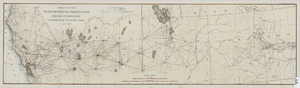
Map of the progress of the transcontinental triangulation and reconnaissance eastward from the Pacific Coast, June 30, 1883
Date
1883-06-30
Description
26 x 93 cm. "Coast and Geodetic Survey report, 1883, no. 23." "June 30, 1883." Original publisher: U.S. Coast and Geodetic Survey, Scale: 1: 2000 000.
Image
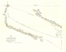
Map of Moapa River Reservation, located and surveyed by C. A. Bateman & A. J. Barnes, U.S. Indian agents, Nevada, 1875
Date
1875
Description
Scale 600 ft. to 1 inch. Relief shown by hachures. Shows buildings. Shows township and range grid. "Rec with Indian office letter June 10 1875. Copies sent to Sup. Gen. and R&R at Pioche Nevada August 9 1875" handwritten in blue ink on verso.
Image