Search Results
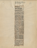
Newspaper clipping, Water wrangle solution?, Las Vegas Review-Journal, November 17, 1944
Date
Archival Collection
Description
Lorenzi recommending a pipeline from Lake Mead to supply water to Las Vegas to guarantee future development in the Las Vegas Valley.
Text
Behar, Maurice Halfon, 1938-
Maurice “Maury” Halfon Behar was born August 27, 1938 in Biarritz, France and spent his early childhood in Bayonne, France. On January 12, 1944, the Nazis took his parents from their home, but Behar was left behind due to a bout with measles. He was then cared for by his neighbor, Marie Cazous, passing as her son, until he was adopted by relatives from the United States and moved to New York City, New York in 1947.
Person
Gragson, Oran K. (Oran Kenneth), 1911-2002
Politician Oran Kenneth Gragson was the longest serving mayor of Las Vegas, Nevada, a position he held from 1959 to 1975. He was born February 14, 1911, near Tucamari, New Mexico. In 1919, his family moved to Arkansas, then later to Texas. Gragson came to the Las Vegas area in 1932, and worked at the Hoover Dam for a short time before finding employment in highway construction. He managed the Boulder Inn Casino and Dance Hall for a brief time, and later opened the North Main Furniture Store, followed by the Charleston Appliance Center.
Person
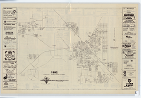
Street map of Henderson, Nevada, 1982
Date
Description
Image
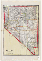
Map of Nevada, circa 1909
Date
Description
Text