Search Results

Map of California and territories of New Mexico and Utah, circa 1861
Date
1859 to 1862
Description
'Compiled, drawn, and engraved under the supervision of J.H. Colton and A.J. Johnson.' Relief shown by hachures and spot heights. Scale [ca. 1:3,041,280]. 1 in. to approx. 48 miles (W 124°--W 103°/N 42°--N 31°). Hand coloredPrime meridians: Greenwich and WashingtonPlates 54 & 55 removed from Johnson's New illustrated family atlas of the world, with descriptions geographical, statistical and historical ... New York, 1862Title page of atlas.
Image
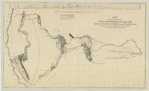
Map of an exploring expedition to the Rocky Mountains in the year 1842 and to Oregon & north California in the years 1843-44
Date
1845
Description
Scale 1:3,000,000. 47.35 miles to 1 in. (W 124°--W 94°/N 46°-- N 34°) ; 1 map ; 76 x 128 cm. ; Relief shown by hachures ; State 3: Includes notes, Great Basin statement, and place name South Park below Bayou Salade; some place names differ from other states ; Includes "Profile of the route from the mouth of the Kansas to the Pacific by Capt. J.C. Fremont in 1843." ; U.S. Senate
Image
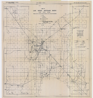
Map of Las Vegas artesian basin, Clark County, Nevada, April 1946 (Water Resources Bulletin no. 4, plate 1)
Date
1946-04
Description
'April, 1946.' 'Showing location of wells, springs, and boundary between valley fill and bedrock.' Originally published as plate 1 in number 4 of the Water resources bulletin published by the Nevada Office of the State Engineer. Scale [ca. 1:63,360. 1 in. to approx. 1 mile] (W 115°10?--N 115°/N 36°20?--N 36°). G4354.L3C34 1946 .N482
Image

Map of Las Vegas Rancho, Lincoln County, Nevada, September 15, 1904
Date
1904-09-15
Description
'Being part of Township 20 S. R.61 E. MT. D. B.&.M, containing 1864.49 acres. Division engineer's office at the front, AMB, September 15th, 1904. A.L. Jones, Division Engineer. Surveyed by W.G. Watson, Assistant Engineer. Dwg. 30296.' Includes traverse table. Shows land owned by the San Pedro, Los Angeles & Salt Lake Railroad, its right of way and the right of way for the Las Vegas & Tonopah Railroad, land owned by the Las Vegas Land & Water Company including Clark's Las Vegas Townsite with the Bucks Addition and the Wardie Addition, and parcels sold from the Las Vegas Land & Water Company land. Scale: [1:9,600]. 1 in. to 800 feet. Library's copies 1 and 4 have land owned by the San Pedro, Los Angeles & Salt Lake Railroad hand-colored in pink and the rest of the Las Vegas Rancho not owned by the Las Vegas Land & Water Company hand-colored in green. Library's copy 2 has buildings of the Stewart Ranch drawn in and labeled in pencil. Library's copy 3 has addition and subtraction problems in pencil on the verso. Library's copy 4 has "Original purchase--1864.49 acres R.R.C. + L.V.L. + W. Co.--In colors." written in pencil on the verso followed by "(1904)" in red pencil. Library's copy 4 also has label on verson made of brown paper with "No 5 Las Vegas Ranch being part township ( 1904)" typed on it.
Image
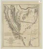
Map of Oregon and upper California from the surveys of John Charles Frémont and other authorities, 1848
Date
1848
Description
'Drawn by Charles Preuss under the order of the Senate of the United States, Washington City, 1848.' 'Lithy. by E. Weber & Co., Balto.' Relief shown by hachures and spot heights. Shows area of U.S. west of the Continental Divide. Includes explanatory notes and shows Frémont's exploring routes in 1842, 1844 and 1846. Scale 1:3,000,000 (W 124°--W 112°/N 42°--N 32°).
Image
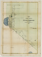
Map of public surveys in Nevada Territory to accompany report of Surveyor General, October 1, 1862
Date
1862-10-01
Description
'Surveyor Generals Office. San Francisco California October 1st 1862. [signed] E.F. Beale, U.S. Surv. Genl. Nevada Terry.' In upper right corner: 'Ho. Reps. Ex. Doc. No. 1. 37th Cong. 3d. Sess.' Relief shown by hachures. Scale [1:253,440] 1 in. to 4 miles (W 120°08--W 118°40/N 39°45--N 38°00)
Image
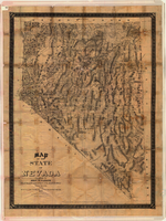
Map of the state of Nevada, 1886
Date
1886
Description
'Compiled by John W. Parker, chief draughtsman of the U.S. Sur. General's Office, Reno, Nevada, from official maps on file on the office, War Department maps and other reliable data. 1886.' 'Entered according to act of Congress, in the year 1886, by John W. Parker, in the office of the Librarian of Congress at Washington.' Relief shown by hachures. Shows townships, including which townships are subdivided, roads, railroads, Indian reservations, etc. Shows range and township grid. Scale [1:760,320]. 1 in. to 12 miles (W 120°--W 114°/N 42°--N 35°).
Image

Map of the state of Nevada to accompany the annual report of the Commr. Genl. Land Office, October 2, 1866
Date
1866-10-02
Description
'Department of the Interior, General Land Office, October 2nd, 1886, [signed] Jos. S. Wilson, Commissioner.' 'The Major & Knapp Eng. Mfg. & Lith. Co. 71 Broadway, N.Y.' Relief shown by hachures. Hand colored. Shows silver, gold, and copper mines. Scale [1:1,140,480]. 18 miles to an in. (W 120°--W 114°/N 42°--N 35°)
Image

Map of California and territories of New Mexico and Utah, circa 1861
Date
1856 to 1866
Description
40 x 60 cm. Relief shown by hachures and spot heights. Prime meridians: Greenwich and Washington. Atlas plate numbers 54 and 55 in the upper corners. Shows forts, trails, exploration routes, drainage, mail steamship routes, physical features, Indian tribes, and historic sites. The geographic region of Southwest is referred to as the New Southwest. Original publisher: Johnson .
Image
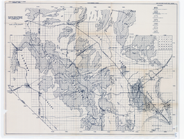
Map showing areas of bedrock and valley fill, drainage boundary, areas of artesian flow, and precipitation stations in the Las Vegas Valley area, 1946
Date
1946
Description
At top of map: 'United Sates Department of Interior, Geological Survey, Water Resources Bulletin no. 5, plate 2.' 'State Engiener of Nevada.' Relief shown by contours and spot heights. Scale [ca. 1:126,720. 1 inch to approx. 2 miles]
Image