
Search the Special Collections and Archives Portal

Search Results

Display    Results Per Page
Displaying results 58631 - 58640 of 59581

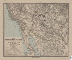
Map of Southwestern United States of America, 1888

Date

1888

Description

33 x 41 cm. Relief shown by hachures and spot heights. 1 sheet of a 6-sheet map. "Petermann: ver. st. v. am. bi. 4". "Stieler's Hand Atlas, No. 86." Binder's title of Hand Atlas über alle Thiele der Erde und über das Weltgebäude, which was published in 1879. In German. Revised 1889. "Neubearbeitret v. H. Habenicht." Original publisher: Justus Perthes, Scale: 1:3,700,000.

Image

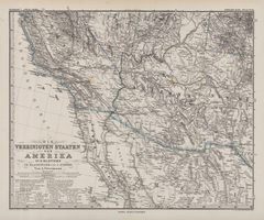
Die Vereinigten Staaten von Amerika in 6 Blättern im Maassstabe von 1:3,700,000

Date

1882

Description

33 x 41 cm. Relief shown by hachures and spot heights. Prime meridian: Greenwich. Sheet 4 of a 6-sheet map. "Petermann: ver. st. v. am. bi. 4". "Stieler's Hand Atlas, No. 86." Binder's title of Hand Atlas über alle Thiele der Erde und über das Weltgebäude, which was published in 1879. In German. Library has only map of Arizona and parts of surrounding states and northern Mexico. Original publisher: Justus Perthes.

Image

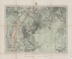
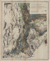
Map of economic features, part of central New Mexico, May 7, 1877

Date

1877-05-07

Description

37 x 50 cm. Relief shown by hachures and spot heights "Atlas sheet no. 77(B)." "Issued May 7th 1877." "Expeditions of 1871 & 1786 under the command of 1st. Lieut. Geo. M. Wheeler, Corps of Engineers, U.S. Army." "Weyss, Herman & Lang, del." "By order of the honorable the Secretary of War." "Under the direction of Brig. General A. A. Hunphreys, Chief of Engineers, U. S. Army." "2nd. Ed. June 30th, 1881." Original publisher: U.S. Geographical Surveys West of the 100th Meridian, Scale: 1 inch to 4 miles or 1: 253440.

Image

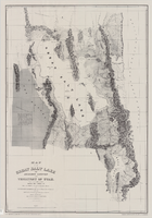
Map of the Great Salt Lake and adjacent country in the territory of Utah, 1852

Date

1852

Description

85 x 58 cm. "Available from the University of Utah Press, Salt Lake City, Utah 84112." Relief shown by hachures and spot heights; depths shown by soundings. "Scale 1:240,000"--inapplicable due to reproduction. Originally published to accompany Stansbury's report, Exploration and survey of the valley of the Great Salt Lake of Utah published in 1852 for the United States Army's Corps of Topographical Engineers. Includes text. Original publisher: University of Utah Press, Scale 1:240,000.

Image

Map of Utah territory representing the extent of the irrigable, timber and pasture lands, 1878

Date

1878

Description

90 x 71 cm. Relief shown by hachures. In bottom margin: "Julius Bien, Lith." "Note. This map has been constructed from atlas sheets of the U.S. Geographical and Geological Survey of the Rocky Mountain Region with additional material taken from the maps of the U.S. Geographical Explorations and Surveys west of the 100th meridian, Lieut. Geo. M. Wheeler, Corps of Engineers, in charge ; the U.S. Geological Exploration of the 40th parallel, Clarence King, U.S. Geologist in charge ; and the U.S. Geologial and Geographical Survey of the Territories, F.V. Hayden, in charge." At head of title: Department of the Interior, U.S. Geographical and Geological Survey of the Rocky Mountain region, J.W. Powell in charge. Original publisher unknown.

Image

Map showing U.S. Bureau of Reclamation Region 3 projects in Arizona, California, Nevada, New Mexico and Utah, September 1967

Date

1967-09

Description

'United States, Department of the Interior, Stewart L. Udall, Secretary. Bureau of Reclamation, Floyd E. Dominy, Commissioner.' 'Map. No. X-300-738. September 1967.' Scale [ca. 1:1,774,080] (W 119°--W 108°/N 39°--N 32°). Relief shown pictorially. Shows completed, under construction and proposed dams and reservoirs, canals, and aqueducts, power plants, pumping plants, substations, transmission lines, tunnels and siphons. Also shows non-Bureau of Reclamation dams, reservoirs, tunnels, pipelines and irrigated lands. Includes inset map of location of Region 3 and key map of drainage basins. Bureau of Reclamation, [Region 3?].

Image

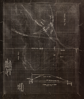
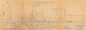
Topographic map showing proposed reservoir for the Las Vegas Rancho, August 4, 1931

Date

1931-08-04

Description

'Chief Engineers Office, Los Angeles, Calif. August 4, 1931. Scale: 1"=100'. Drawn by L.P.D. 1"=10'.' Accompanies: Letter from R. L. Adamson to F. H. Knickerbocker, August 18, 1931 (Folder 6B: 18-1-9).

Image

Map to accompany agreement with Willie T. Stewart covering lease of land at Las Vegas, Nevada, August 10, 1943

Date

1943-08-10

Description

'Las Vegas Land and Water Company.' 'Office of Vice President, Los Angeles, California, August 10, 1943.' Relief shown by contours. Cadastral map. Scale [ca. 1:7,200]. 1 in.=600 feet..

Image

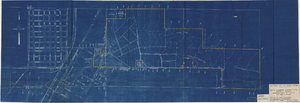
Map showing property to be leased to Willie T. Stewart, Vernon E. Bunker, Earl Leavitt and William Udell Stewart at Las Vegas, Nevada, January 31, 1951

Date

1951-01-31

Description

'Office of Vice President, Los Angeles, California.' Accompanies: William Reinhardt letter to A. E. Stoddard, January 31, 1951 (Box 11 Folder W18-1-12).

Image

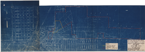
Map showing location of leased properties proposed to be sold to the Las Vegas Land and Water Company, October 2, 1952

Date

1952-10-02

Description

'October 2, 1952.' Relief shown by contours. Hand-drawn lines mark land leased to these people, land proposed to be withdrawn from lease, and easement for a sewer. Scale [ca. 1:7,200]. 1 in.=600 feet. Blueline.

Image