Search Results

Photograph of Howard Hughes and his crew at a parade, New York, July 15, 1938
Date
1938-07-15
Archival Collection
Description
Typed onto a piece of paper attached to the image: "Howard Hughes and crew in parade up Broadway after record-breaking world flight. New York, New York."
Image

Photograph of Howard Hughes and his crew at a parade, New York, July 15, 1938
Date
1938-07-15
Archival Collection
Description
The view of Howard Hughes and his crew at a parade after he completed his Round-The-World flight in New York.
Image

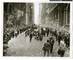
Photograph of Howard Hughes and his crew at a parade, New York, July 15, 1938
Date
1938-07-15
Archival Collection
Description
The black and white view of Howard Hughes and his crew at a parade after he completed his Round-The-World flight in New York. Handwritten on the back of the image: "B' way parade temporarily blocked by fire engines answering false alarm. 7/15/38."
Image

Photograph of Howard Hughes and his crew at a parade, New York, July 15, 1938
Date
1938-07-15
Archival Collection
Description
The black and white view of Howard Hughes and his crew at a parade after he completed his Round-The-World flight in New York.
Image
Photograph of Howard Hughes and his crew at a parade, New York, July 15, 1938
Date
1938-07-15
Archival Collection
Description
The black and white view of Howard Hughes and his crew at a parade after he completed his Round-The-World flight in New York.
Image
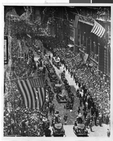
Photograph of a parade procession, New York, July 15, 1938
Date
1938-07-15
Archival Collection
Description
Description printed on photograph's accompanying sheet of paper: "New York reception for Howard Hughes and his companions after completing a round the world flight. 7-15-38 (Press Association)."
Image

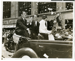
Photograph of a parade procession for Howard Hughes, New York, July 15, 1938
Date
1938-07-15
Archival Collection
Description
Photograph of Grover Whalen, Howard Hughes, and Al Lodwick during a parade procession for the completion of Hughes' Round-the-World flight.
Image
Photograph of a parade procession for Howard Hughes, New York, July 15, 1938
Date
1938-07-15
Archival Collection
Description
Photograph of Grover Whalen, Howard Hughes, and Al Lodwick during a parade procession for the completion of Hughes' Round-the-World flight.
Image
Photograph of a parade procession for Howard Hughes, New York, July 15, 1938
Date
1938-07-15
Archival Collection
Description
A view of Grover Whalen, Howard Hughes, and Al Lodwick riding in the back of an automobile during a parade procession. Description printed on back of photograph: "Howard Hughes welcomed at City Hall, New York. General scene. 7/15/38."
Image

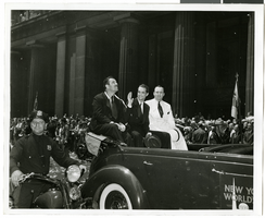
Photograph of a parade procession for Howard Hughes, New York, July 15, 1938
Date
1938-07-15
Archival Collection
Description
A view of Grover Whalen, Howard Hughes, and Al Lodwick riding in the back of an automobile during a parade procession. Description printed on photograph's accompanying sheet of paper: "Howard Hughes (center), Grover Whalen (Left) and Albert Lodwick during the New York reception for Hughes after completing his round-the-world flight. 7/15/38."
Image