Search Results
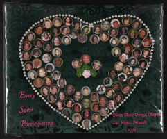
Alpha Kappa Alpha Sorority, Theta Theta Omega Chapter scrapbook: "Every soror participating"
Date
2008
Archival Collection
Description
From the Alpha Kappa Alpha Sorority, Incorporated, Theta Theta Omega Chapter Records (MS-01014).
Mixed Content
Bluebell Girls: scrapbook of newspaper clippings and photographs
Date
1939 to 1960
Archival Collection
Description
From the Margaret Kelly Collection on the Bluebell Girls, MS-00604. The scrapbook includes newspaper clippings about the Bluebell Girls, Folies-Bergère, and dancer Catherine Dunne's experiences in Milan, Italy at the start of World War II.
Mixed Content
Meeting minutes for Consolidated Student Senate, University of Nevada, Las Vegas, July 26, 2004
Date
2004-07-26
Archival Collection
Description
Includes meeting minutes and agenda, along with additional information about contracts.
Text

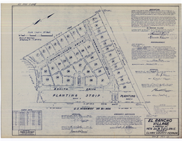
Plat map of El Rancho Village, Clark County, Nevada, July 28, 1942
Date
1942-07-28
Description
Map of housing subdivision outside the Las Vegas city limits. 'Approved this 28 day of July1942, by the City Planning Commission of the City of Las Vegas, County of Clark, Nevada. Approved this 28 day of July 1942, by the County Planning Commission of the County of Clark, State of Nevada.' Blueline print. Oriented with north to the upper right. Embossed with Engineering Certificate seal of Frank D. Rathburn, which states. 'Survey completed August 4, 1942.' 'Book II, page 53' hand printed in lower right corner. Signed by Clark County, Nevada Notary Public and other coumty officials and officials of El Rancho Village. Published by Office of F.D. Rathbun. Scale [ca. 1:600]. 1 inch to 50 feet
Text
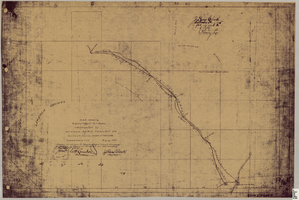
Map showing right of way of toll road constructed by Nevada Rapid Transit Co. in Lincoln County, State of Nevada
Date
1905-08-10
Description
Shows right of way of what now is Interstate 95 through what is now Clark County, Nevada. 'Aug. 10, 1905.' 'Adopted as toll road of Nevada Rapid Transit Company at meeting of Board of Directors of said company Aug. 25th, 1905. Attest W.H. Comstock, secretary, J. Ross Clark, president.' 'Book I, page 3'--Lower right corner. '... No. ... Recorded at ... [signed] J. Ross Clark ... September 1st A.D. 1905 at 40 ... past 8 A.M. to Book of Platts, Pages ... Lincoln Co. Nev. Record ... [signed] Henry Lee ...'--upper right portion of map. Seal of the Nevada Rapid Transit Company in lower left portion of map. Scale [ca. 126,720]. 1 in.=2 miles 1 map. Blueline print.
Image

Geologic map and sections of area along Colorado River between Lake Mead and Davis Dam, Arizona and Nevada, 1963
Date
1963
Description
At top of map: 'United States, Department of Interior, Geological Survey. Professional Paper 374-E, plate 1.' In lower right corner of map: 'Geology mapped by C.R. Longwell.' Relief shown by contours. Includes seven colored cross-sections. Scale 1:125,000 (W 114°50´--W 114°20´/N 36°10´--N 35°10´). Series: Shorter contributions to general geology. Professional paper (Geological Survey (U.S.))374-E. Originally published as plate 1 in: Reconnaissance geology between Lake Mead and Davis Dam, Arizona-Nevada / by Chester R. Longwell, published by the U.S. Government Printing Office in 1963 in the series Shorter contributions to general geology and as Geological Survey professional paper 374-E.
Image

Map of the Las Vegas ground-water basin, Clark, Nye, and Lincoln Counties, Nevada, 1965
Date
1965
Description
At top of map: 'United States Department of the Interior, Geological Survey. Water-supply paper 1780, plate 1.' At bottom of map: 'Base from Army Map Service sheets NJ 11-9, NJ 11-12, and NI 11-3 (1947).' 'Boundary between bedrock and alluvium in Clark County, Nev., compiled by Ben Boyer, E. H. Pampeyan and C. R. Longwell. In Lincoln and Nye Counties, contact determined from aerial photographs.' 'Interior--Geological Survey, Washington, D.C.--1965--W63358.' Includes township and range lines.Relief shown by contours. Thematic map. Scale 1:250,000 (W 116°--W 114°45´/N 37°00´--N 35°30´). Series: Water-supply paper (Washington, D.C.), 1780. Originally published as plate 1 of Available water supply of the Las Vegas ground-water basin, Nevada, by Glenn T. Malmberg, published by the Geological Survey in 1965 as its Water-supply paper 1780.
Image