Search Results
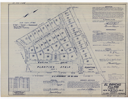
Plat map of El Rancho Village, Clark County, Nevada, July 28, 1942
Date
Description
Text

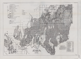
General geologic map of Las Vegas, Pahrump, and Indian Spring Valleys, Clark and Nye Counties, Nevada, 1948
Date
Description
At top of map: 'United States Department of the Interior, Geological Survey. State Engineer of Nevada. Water resources bulletin No. 5, Plate 1.' Relief shown by spot heights. Includes 3 inset maps of wells and springs in the vicinity of Pahrump, Manse Ranch and Indian Springs, Nevada. Scale [ca. 1:126,720. 1 inch to approx. 2 miles] (W 116°--W 115°/N 40°--N 36°). Originally published as plate 1 in Geology and water resources of Las Vegas, Pahrump, and Indian Spring Valleys, Clark and Nye Counties, Nevada by George B. Maxey and C.H. Jameson (1948), which is number 5 of the Water resources bulletin published by the Nevada Office of the State Engineer.
Image

Topographic map of the Las Vegas Valley area, 1959
Date
Description
Image

Original plat, townsite of Las Vegas, Lincoln Co., Nevada, January 13, 1905
Date
Description
Subtitle: 'Embracing the N. 1/2 of S.W. 1/4 Sec. 27 Township 20S. R.61E. Mt. Diablo Meridian.' 'Book 1, page 17A" handwritten in lower right corner. Signed by Henry Lee, County Recorder, Lincoln County Nevada. 'Filed at request of J.T. Williams, January 13th A.D. 1905.' Backwards handwriting on right side. Map has a Lincoln County seal on the bottom near the center. In the dedication J.T. McWilliams states that he has surveyed and platted the townsite of Las Vegas subject to the right of way of the San Pedro, Los Angeles and Salt Lake Railroad Company. He signed the dedication on Jan. 13, 1905, and it was signed by witnesses Scale [ca. 1:2,520? 1 inch to approx. 210 feet?]. Copy of a blueline print.
Image
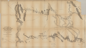
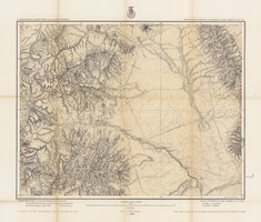
Map based on reconnaissance of the Zuñi, Little Colorado and Colorado Rivers in 1851 by U.S. Corps of Topographical Engineers
Date
Description
Image
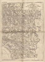
Map of part of south western Colorado, January 10, 1878
Date
Description
38 x 49 cm.
Relief shown by hachures and spot heights. "Atlas sheet no. 61(D)."
"Issued Jan. 10th 1878."
"Expeditions of 1873, 74, 75 & 76 under the command of 1st. Lieut. Geo. M. Wheeler, Corps of Engineers, U.S. Army."
Prime meridians: Washington, D.C. and Greenwich. Includes sectional diagram showing how atlas sheets fit together. "Weyss, Lang & Herman, del." "By order of the honorable the Secretary of War." "Under the direction of Brig. General A. A. Hunphreys, Chief of Engineers, U. S. Army." " J. C. Spiller, Louis Nell, topographical assistants." "Expeditions of 1873, 74, 75 & 76 under the command of 1st. Lieutenant William L. Marshall, Corps of Engineers, U. S. Army, 1st Lieutenant Eric Bergland, Corps of Engineers, U. S. Army, Executive Officers and field astronomers."
Original publisher: U.S. Geographical Surveys West of the 100th Meridian, Scale 1 inch to 4 miles or 1:253440.
Image
General geologic map of the Corners area, Arizona-Nevada-Utah, April 15, 1952
Date
Archival Collection
Description
Image
General map showing approximate location of better known springs and wells in the Mohave and adjacent deserts, southeastern California and southwestern Nevada, circa 1908-1909
Date
Description
224. Map is plate 1 from the U.S. Geological Survey Water-supply paper 224.
Image