Search Results


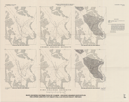
Maps showing distribution of coarse- and fine-grained deposits in the upper 1,000 feet of valley fill, Las Vegas Valley, Nevada, 1981 (Water-supply paper 2320-A, plate 3)
Date
1981
Description
'Department of Interior, U.S. Geological Survey. Water-supply paper 2320-A, plate 3.' 'Prepared in cooperation with the Clark County Department of Comprehensive Planning.' 'Base from U.S. Geological Survey, 1:250,000, Las Vegas and Kingman, 1969.' 'Geology from Malmberg (1965); Longwell and others (1965); and J. R. Harrill, 1976. Lithology by R.W. Plume, 1981.' Contents: Coarse-grained deposits: 0-200 feet below land surface; 200-700 feet below land surface; 700-1,000 feet below land surface -- Fine-grained deposits: 0-200 feet below land surface; 200-700 feet below land surface; 700-1,000 feet below land surface. Scale [ca. 1:316,800. 1 in.=approx. 5 miles]. Series: U.S. Geological Survey water-supply paper2320-A. Originally published as plate 3 of Ground-water conditions in Las Vegas Valley, Clark County, Nevada. Part I. Hydrogeologic framework / by Russell W. Plume, published by the U.S. Geological Survey in 1989 as Water-supply paper 2320-A.United States Dept. of the Interior, Geological Survey.
Image
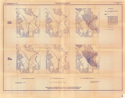
Maps showing distribution of coarse- and fine-grained deposits in the upper 1,000 feet of valley fill, Las Vegas Valley, Nevada, 1981 (Open-file report 84-130, plate 3)
Date
1981
Description
'United States Department of the Interior, Geological Survey. Open-file report 84-130, plate 3.' 'Prepared in cooperation with the Clark County Department of Comprehensive Planning.' 'Base from U.S. Geological Survey, 1:250,000, Las Vegas and Kingman, 1969.' 'Geology from Malmberg (1965); Longwell and others (1965); and J. R. Harrill, 1979. Lithology by R.W. Plume, 1981.' Contents: Coarse-grained deposits: 0-200 feet below land surface; 200-700 feet below land surface; 700-1,000 feet below land surface -- Fine-grained deposits: 0-200 feet below land surface; 200-700 feet below land surface; 700-1,000 feet below land surface. Scale [ca. 1:310,464. 1 in.=approx. 4.9 miles]. Series: Open-file report (Geological Survey (U.S.))84-130 Originally published as plate 3 of Ground-water conditions in Las Vegas Valley, Clark County, Nevada. Part I. Hydrogeologic framework / by Russell W. Plume, published by the U.S. Geological Survey in 1984 as Open-file report 84-130.
Image