Search Results
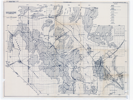
Map showing areas of bedrock and valley fill, drainage boundary, areas of artesian flow, and precipitation stations in the Las Vegas Valley area, 1946
Date
1946
Description
At top of map: 'United Sates Department of Interior, Geological Survey, Water Resources Bulletin no. 5, plate 2.' 'State Engiener of Nevada.' Relief shown by contours and spot heights. Scale [ca. 1:126,720. 1 inch to approx. 2 miles]
Image

Map of the city of Las Vegas, Nevada, June 1, 1946
Date
1946-06-01
Description
Scale [ca. 1:9,600. 1 in. to approx. 800 ft.]. Cadastral map. 'Compiled by Pioneer Title Insurance &Trust Company.' 'By Jack Asher, State Nev. Reg. Engr. No. 305.' 'Issue 5, 6/1/46.' Includes indexes. Pioneer Title Insurance &Trust Company
Image
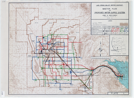
Topographic map of master plan for proposed water supply system for Las Vegas Valley Water District, August 1960
Date
1960-08
Description
Scale [ca. 1:63,360. 1 in. to approx. 1 mile]. Relief shown by contour lines. Includes inset location map of Water District. 'August 1960.' 'Plate 1.' Las Vegas Valley Water District
Image
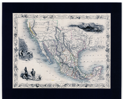
Map of Mexico, California and Texas, 1851
Date
1851
Description
'The map drawn and engraved by J. Rapkin.' Scale [ca. 1:14,256,000. 1 in. to approx. 225 miles] (W125°-- W80°/N 42°--N 15°). Relief shown by hachures. Prime meridian: Greenwich. Hand colored. Includes illustrations: Gold washing -- Mexican peasantry --Ruins at Uxmal, Yucatan. Includes decorative border. Library's copy is matted. Originally published as Map 70 of The Illustrated Atlas And Modern History Of The World, Geographical, Political, Commercial & Statistical, edited by R. Montgomery Martin, Esq., London & New York, J. & F. Tallis, 1851. Illustrated atlas and modern history of the world, geographical, political, commercial & statistical
Image
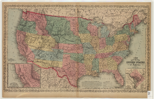
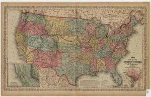
Map of the United States of America, 1859
Date
1859
Description
'Philadelphia. Published by Charles Desilver ... 1859.' Entered according to Act of Congress in the year 1856 by Charles Desilver in the Clerks office of the District Court of the Eastern District of Pennsylvania.' 'Engraved by J.L. Hazzard & E. Yeager.' Includes notes and insets titled 'Gold region of California' and 'District of Columbia.' Relief shown by hachures and spot heights. Also shows battle fields and proposed western railroad routes. Prime meridians: Washington and Greenwich. Atlas p. numbers in upper margin: 5-6. Scale 1:8,750,000 (W 126°--W 65°/N 48°--N 24°)
Image
Map of the United States of America, 1856
Date
1856
Description
'Philadelphia. Published by Charles Desilver.' 'Entered according to Act of Congress in the year 1856 by Charles Desilver in the Clerks office of the District Court of the Eastern District of Pennsylvania.' 'Engraved by J.L. Hazzard & E. Yeager.' Includes notes and insets titled 'Gold region of California' and 'District of Columbia.' Relief shown by hachures and spot heights. Also shows battle fields and proposed western railroad routes. Prime meridians: Washington and Greenwich. Atlas p. numbers in upper margin: 5-6. Scale 1:8,750,000 (W 126°--W 65°/N 48°--N 24°).
Image

Plat showing original townsite and subdivisions, Las Vegas, Lincoln County, Nevada, May 1905
Date
1905-05
Description
Land owned by the San Pedro, Los Angeles & Salt Lake Railroad is outlined. Scale: [ca. 1:12,000]. 1 inch = 1,000 feet. Cadastral map. Blueline print. Additional copy available in the J.T. McWilliams manuscript collection
Image

Map showing second stage plan of development for Southern Nevada Water Project, March 1981
Date
1981-03
Description
'United States Department of the Interior, Bureau of Reclamation.' 'June 1976. Revised March 1981.' 'Map No. 952-300-203.' 'Exhibit I.' Includes inset location map for project area. Scale [ca. 1:126,720. 1 in. to approx. 2 miles] . United States Department of the Interior, Bureau of Reclamation
Image
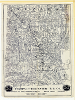
Map showing Tonopah & Tidewater Railroad Company line from Ludlow, California to Goldfield, Nevada, circa 1907
Date
1905 to 1909
Description
Scale not given. Relief shown by hachures and spot heights. Shows township and range grid. Shows mines, camps and ranches. Tonopah & Tidewater Railroad Company. Library's copy mounted on linen.
Image
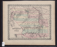
Map showing the territories of New Mexico and Utah, 1855
Date
1855
Description
'Entered according to Act of Congress in the year 1855 by J.H. Colton & Co. in the Clerk's Office of the Dist. Court of the U.S. for the South'n. Dist. of New York.' Scale [ca. 1:4,752,000. 1 in. to approx. 75 miles] (W 120°--W 102°/N 43°--N 32°). Shows natural features, and populated places, wagon route, proposed railroad routes and explorers' routes. Relief shown by hachures. Prime meridians: Greenwich and Washington.Hand colored. Atlas p. number in lower-right margin: 51. Decorative border. J.H. Colton & Co.
Image