Search the Special Collections and Archives Portal
Search Results
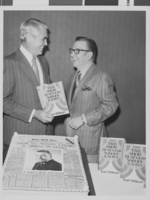
Photograph of Mayor Oran K. Gragson (left) with author Earl Wilson, circa 1971
Date
1969 to 1972
Archival Collection
Description
Las Vegas Mayor Oran K. Gragson (left) with author Earl Wilson. Mayor Gragson is holding a copy of Earl's book, The Show Business Nobody Knows. A large cake decorated as a newspaper announcing the publishing of the book sits on the table in front of them. The location where the photograph was taken is unknown. Oran Kenneth Gragson (February 14, 1911 – October 7, 2002) was an American businessman and politician. He was the longest-serving mayor of Las Vegas, Nevada, from 1959 to 1975. Gragson, a member of the Republican Party, was a small business owner who was elected Mayor on a reform platform against police corruption and for equal opportunity for people of all socio-economic and racial categories. Gragson died in a Las Vegas hospice on October 7, 2002, at the age of 91. The Oran K. Gragson Elementary School located at 555 N. Honolulu Street, Las Vegas, NV 89110 was named in his honor. Earl Wilson (May 3, 1907–January 16, 1987), born Harvey Earl Wilson, was an American journalist, gossip columnist and author, perhaps best known for his nationally syndicated newspaper column, It Happened Last Night. Wilson's column originated from the New York Post and ran from 1942 until 1983. His chronicling of the Broadway theatre scene during the "Golden Age" of show business formed the basis for a book published in 1971, The Show Business Nobody Knows. He signed his columns with the tag line, "That's Earl, brother." His nickname was "Midnight Earl". In later years, the name of his column was changed to Last Night With Earl Wilson. In his final years with the Post, he alternated with the paper's entertainment writer and restaurant critic, Martin Burden, in turning out the column. (Burden, who died in 1993, took over the Last Night column full-time upon Wilson's retirement.) Wilson is also the author of two controversial books, Show Business Laid Bare, and an unauthorized biography of Frank Sinatra, Sinatra – An Unauthorized Biography. The former book is notable for revealing the extramarital affairs of President John F. Kennedy.
Image

Film transparency of Mr. L. J. (Lewis J.) Murphy and the famous Tom Kelly Bottle House in Rhyolite, Nevada, November 25, 1948
Date
1948-11-25
Archival Collection
Description
Mr. L. J. (Lewis J.) Murphy and the famous Tom Kelly Bottle House in Rhyolite, Nevada, which he operated as a free museum in the old ghost town. L. J. Murphy took care of the Bottle House from 1929 until his death in 1953. Two wagon wheels are visible in the front yard. Rhyolite is a ghost town in Nye County, Nevada. It is in the Bullfrog Hills, about 120 miles (190 km) northwest of Las Vegas, near the eastern edge of Death Valley. The town began in early 1905 as one of several mining camps that sprang up after a prospecting discovery in the surrounding hills. During an ensuing gold rush, thousands of gold-seekers, developers, miners and service providers flocked to the Bullfrog Mining District. Many settled in Rhyolite, which lay in a sheltered desert basin near the region's biggest producer, the Montgomery Shoshone Mine. Rhyolite declined almost as rapidly as it rose. After the richest ore was exhausted, production fell. The 1906 San Francisco earthquake and the financial panic of 1907 made it more difficult to raise development capital. In 1908, investors in the Montgomery Shoshone Mine, concerned that it was overvalued, ordered an independent study. When the study's findings proved unfavorable, the company's stock value crashed, further restricting funding. By the end of 1910, the mine was operating at a loss, and it closed in 1911. By this time, many out-of-work miners had moved elsewhere, and Rhyolite's population dropped well below 1,000. By 1920, it was close to zero. After 1920, Rhyolite and its ruins became a tourist attraction and a setting for motion pictures. Most of its buildings crumbled, were salvaged for building materials, or were moved to nearby Beatty or other towns, although the railway depot and a house made chiefly of empty bottles were repaired and preserved. The town is named for rhyolite, an igneous rock composed of light-colored silicates, usually buff to pink and occasionally light gray. It belongs to the same rock class, felsic, as granite but is much less common.
Image
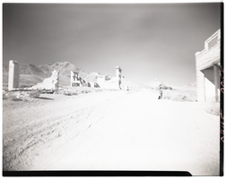
Film transparency of a boy looking at an abandonded building, Rhyolite, Nevada, November 25, 1948
Date
1948-11-25
Archival Collection
Description
A young boy looks at the ruins of the H. D. and L. D. Porter Brothers Store in Rhyolite, Nevada. Several other buildings are visible in the background. Rhyolite is a ghost town in Nye County, Nevada. It is in the Bullfrog Hills, about 120 miles (190 km) northwest of Las Vegas, near the eastern edge of Death Valley. The town began in early 1905 as one of several mining camps that sprang up after a prospecting discovery in the surrounding hills. During an ensuing gold rush, thousands of gold-seekers, developers, miners and service providers flocked to the Bullfrog Mining District. Many settled in Rhyolite, which lay in a sheltered desert basin near the region's biggest producer, the Montgomery Shoshone Mine. Rhyolite declined almost as rapidly as it rose. After the richest ore was exhausted, production fell. The 1906 San Francisco earthquake and the financial panic of 1907 made it more difficult to raise development capital. In 1908, investors in the Montgomery Shoshone Mine, concerned that it was overvalued, ordered an independent study. When the study's findings proved unfavorable, the company's stock value crashed, further restricting funding. By the end of 1910, the mine was operating at a loss, and it closed in 1911. By this time, many out-of-work miners had moved elsewhere, and Rhyolite's population dropped well below 1,000. By 1920, it was close to zero. After 1920, Rhyolite and its ruins became a tourist attraction and a setting for motion pictures. Most of its buildings crumbled, were salvaged for building materials, or were moved to nearby Beatty or other towns, although the railway depot and a house made chiefly of empty bottles were repaired and preserved. The town is named for rhyolite, an igneous rock composed of light-colored silicates, usually buff to pink and occasionally light gray. It belongs to the same rock class, felsic, as granite but is much less common.
Image
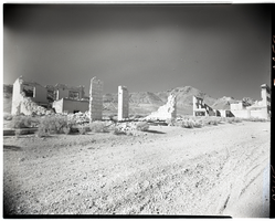
Film transparency of buildings located on Golden Street, Rhyolite, Nevada, November 25, 1948
Date
1948-11-25
Archival Collection
Description
Two buildings that were located on Golden Street in Rhyolite, Nevada. The building on the left was possibly the John T. Overbury building. The building on the right was the John S. Cook & Co. Bank building. Rhyolite is a ghost town in Nye County, Nevada. It is in the Bullfrog Hills, about 120 miles (190 km) northwest of Las Vegas, near the eastern edge of Death Valley. The town began in early 1905 as one of several mining camps that sprang up after a prospecting discovery in the surrounding hills. During an ensuing gold rush, thousands of gold-seekers, developers, miners and service providers flocked to the Bullfrog Mining District. Many settled in Rhyolite, which lay in a sheltered desert basin near the region's biggest producer, the Montgomery Shoshone Mine. Rhyolite declined almost as rapidly as it rose. After the richest ore was exhausted, production fell. The 1906 San Francisco earthquake and the financial panic of 1907 made it more difficult to raise development capital. In 1908, investors in the Montgomery Shoshone Mine, concerned that it was overvalued, ordered an independent study. When the study's findings proved unfavorable, the company's stock value crashed, further restricting funding. By the end of 1910, the mine was operating at a loss, and it closed in 1911. By this time, many out-of-work miners had moved elsewhere, and Rhyolite's population dropped well below 1,000. By 1920, it was close to zero. After 1920, Rhyolite and its ruins became a tourist attraction and a setting for motion pictures. Most of its buildings crumbled, were salvaged for building materials, or were moved to nearby Beatty or other towns, although the railway depot and a house made chiefly of empty bottles were repaired and preserved. The town is named for rhyolite, an igneous rock composed of light-colored silicates, usually buff to pink and occasionally light gray. It belongs to the same rock class, felsic, as granite but is much less common.
Image
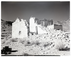
Film transparency of the ruins of possibly the John T. Overbury building, Rhyolite, Nevada, November 25, 1948
Date
1948-11-25
Archival Collection
Description
Film transparency of the ruins of possibly the John T. Overbury building, Rhyolite, Nevada. Rhyolite is a ghost town in Nye County, Nevada. It is in the Bullfrog Hills, about 120 miles (190 km) northwest of Las Vegas, near the eastern edge of Death Valley. The town began in early 1905 as one of several mining camps that sprang up after a prospecting discovery in the surrounding hills. During an ensuing gold rush, thousands of gold-seekers, developers, miners and service providers flocked to the Bullfrog Mining District. Many settled in Rhyolite, which lay in a sheltered desert basin near the region's biggest producer, the Montgomery Shoshone Mine. Rhyolite declined almost as rapidly as it rose. After the richest ore was exhausted, production fell. The 1906 San Francisco earthquake and the financial panic of 1907 made it more difficult to raise development capital. In 1908, investors in the Montgomery Shoshone Mine, concerned that it was overvalued, ordered an independent study. When the study's findings proved unfavorable, the company's stock value crashed, further restricting funding. By the end of 1910, the mine was operating at a loss, and it closed in 1911. By this time, many out-of-work miners had moved elsewhere, and Rhyolite's population dropped well below 1,000. By 1920, it was close to zero. After 1920, Rhyolite and its ruins became a tourist attraction and a setting for motion pictures. Most of its buildings crumbled, were salvaged for building materials, or were moved to nearby Beatty or other towns, although the railway depot and a house made chiefly of empty bottles were repaired and preserved. The town is named for rhyolite, an igneous rock composed of light-colored silicates, usually buff to pink and occasionally light gray. It belongs to the same rock class, felsic, as granite but is much less common.
Image
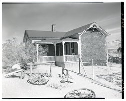
Film transparency of the famous Tom Kelly Bottle House in Rhyolite, Nevada, November 25, 1948
Date
1948-11-25
Archival Collection
Description
The famous Tom Kelly Bottle House in Rhyolite, Nevada, which L. J. (Lewis J. Murphy operated as a free museum in the old ghost town from 1929 until his death in 1953. Two wagon wheels are visible in the front yard. Rhyolite is a ghost town in Nye County, Nevada. It is in the Bullfrog Hills, about 120 miles (190 km) northwest of Las Vegas, near the eastern edge of Death Valley. The town began in early 1905 as one of several mining camps that sprang up after a prospecting discovery in the surrounding hills. During an ensuing gold rush, thousands of gold-seekers, developers, miners and service providers flocked to the Bullfrog Mining District. Many settled in Rhyolite, which lay in a sheltered desert basin near the region's biggest producer, the Montgomery Shoshone Mine. Rhyolite declined almost as rapidly as it rose. After the richest ore was exhausted, production fell. The 1906 San Francisco earthquake and the financial panic of 1907 made it more difficult to raise development capital. In 1908, investors in the Montgomery Shoshone Mine, concerned that it was overvalued, ordered an independent study. When the study's findings proved unfavorable, the company's stock value crashed, further restricting funding. By the end of 1910, the mine was operating at a loss, and it closed in 1911. By this time, many out-of-work miners had moved elsewhere, and Rhyolite's population dropped well below 1,000. By 1920, it was close to zero. After 1920, Rhyolite and its ruins became a tourist attraction and a setting for motion pictures. Most of its buildings crumbled, were salvaged for building materials, or were moved to nearby Beatty or other towns, although the railway depot and a house made chiefly of empty bottles were repaired and preserved. The town is named for rhyolite, an igneous rock composed of light-colored silicates, usually buff to pink and occasionally light gray. It belongs to the same rock class, felsic, as granite but is much less common.
Image
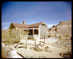
Film transparency of the famous Tom Kelly Bottle House in Rhyolite, Nevada, November 25, 1948
Date
1948-11-25
Archival Collection
Description
The famous Tom Kelly Bottle House in Rhyolite, Nevada, which L. J. (Lewis J. Murphy operated as a free museum in the old ghost town from 1929 until his death in 1953. Two wagon wheels are visible in the front yard. Rhyolite is a ghost town in Nye County, Nevada. It is in the Bullfrog Hills, about 120 miles (190 km) northwest of Las Vegas, near the eastern edge of Death Valley. The town began in early 1905 as one of several mining camps that sprang up after a prospecting discovery in the surrounding hills. During an ensuing gold rush, thousands of gold-seekers, developers, miners and service providers flocked to the Bullfrog Mining District. Many settled in Rhyolite, which lay in a sheltered desert basin near the region's biggest producer, the Montgomery Shoshone Mine. Rhyolite declined almost as rapidly as it rose. After the richest ore was exhausted, production fell. The 1906 San Francisco earthquake and the financial panic of 1907 made it more difficult to raise development capital. In 1908, investors in the Montgomery Shoshone Mine, concerned that it was overvalued, ordered an independent study. When the study's findings proved unfavorable, the company's stock value crashed, further restricting funding. By the end of 1910, the mine was operating at a loss, and it closed in 1911. By this time, many out-of-work miners had moved elsewhere, and Rhyolite's population dropped well below 1,000. By 1920, it was close to zero. After 1920, Rhyolite and its ruins became a tourist attraction and a setting for motion pictures. Most of its buildings crumbled, were salvaged for building materials, or were moved to nearby Beatty or other towns, although the railway depot and a house made chiefly of empty bottles were repaired and preserved. The town is named for rhyolite, an igneous rock composed of light-colored silicates, usually buff to pink and occasionally light gray. It belongs to the same rock class, felsic, as granite but is much less common.
Image
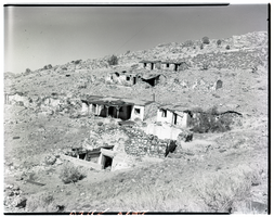
Film transparency of a ghost town, Delamar, Nevada, 1956
Date
1956
Archival Collection
Description
A view of some of the abandonded buildings on a hillside in Delamar, Nevada. One of the structures has a covered porch Delamar, Nevada, nicknamed The Widowmaker, is a ghost town in central eastern Nevada, USA along the east side of the Delamar Valley. During its heyday, primarily between 1895 and 1900, it produced $13.5 million in gold. In 1889, prospectors John Ferguson and Joseph Sharp discovered gold around Monkeywrench Wash. A mining camp was then born west of the Monkeywrench Mine. It was called Ferguson. In April 1894, Captain Joseph Raphael De Lamar bought most of the important mines in the area and renamed the Ferguson camp as Delamar. In the same year, a newspaper called the Delamar Lode began publication and a post office was opened. Soon, the new settlement boasted more than 1,500 residents, a hospital, an opera house, churches, a school, several businesses and saloons. Most buildings were made of native rock. By 1896, the Delamar mill was handling up to 260 tons of ore daily. Water for the camp was pumped from a well in Meadow Valley Wash, some twelve miles away. Supplies and materials traveled even further, by mule team over mountainous terrain from the railroad head at Milford, Utah, which was 150 miles from Delamar. Silicosis The gold in the Delamar mines was embedded in quartzite which when crushed created a fine dust. Miners breathing the dust often developed silicosis and the town became known as a "widow-maker." Many ruins now stand semi-intact in the Delamar ghost town region. Foundations can easily be seen from adjacent hills. There are two graveyards, which have been vandalized. The area is honeycombed with mines and mineshafts, but in recent years the main shaft has been blasted closed. Wild horses roam the area. The nearby dry lake is known to pilots as Texas Lake because its outline resembles the state of Texas.
Image
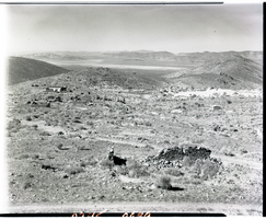
Film transparency of a ghost town, Delamar, Nevada, 1956
Date
1956
Archival Collection
Description
A view of some of the abandonded buildings in Delamar, Nevada, taken from a nearby hill. Delamar, Nevada, nicknamed The Widowmaker, is a ghost town in central eastern Nevada, USA along the east side of the Delamar Valley. During its heyday, primarily between 1895 and 1900, it produced $13.5 million in gold. In 1889, prospectors John Ferguson and Joseph Sharp discovered gold around Monkeywrench Wash. A mining camp was then born west of the Monkeywrench Mine. It was called Ferguson. In April 1894, Captain Joseph Raphael De Lamar bought most of the important mines in the area and renamed the Ferguson camp as Delamar. In the same year, a newspaper called the Delamar Lode began publication and a post office was opened. Soon, the new settlement boasted more than 1,500 residents, a hospital, an opera house, churches, a school, several businesses and saloons. Most buildings were made of native rock. By 1896, the Delamar mill was handling up to 260 tons of ore daily. Water for the camp was pumped from a well in Meadow Valley Wash, some twelve miles away. Supplies and materials traveled even further, by mule team over mountainous terrain from the railroad head at Milford, Utah, which was 150 miles from Delamar. Silicosis The gold in the Delamar mines was embedded in quartzite which when crushed created a fine dust. Miners breathing the dust often developed silicosis and the town became known as a "widow-maker." Many ruins now stand semi-intact in the Delamar ghost town region. Foundations can easily be seen from adjacent hills. There are two graveyards, which have been vandalized. The area is honeycombed with mines and mineshafts, but in recent years the main shaft has been blasted closed. Wild horses roam the area. The nearby dry lake is known to pilots as Texas Lake because its outline resembles the state of Texas.
Image
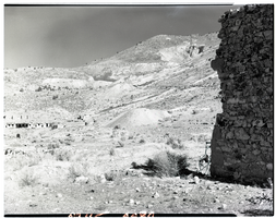
Film transparency of a ghost town, Delamar, Nevada, 1956
Date
1956
Archival Collection
Description
Some of the abandonded buildings in Delamar, Nevada. A tailing pile from one of the mines is visible in the center of the photograph. A stone structure is visible on the right side of the photograph. Delamar, Nevada, nicknamed The Widowmaker, is a ghost town in central eastern Nevada, USA along the east side of the Delamar Valley. During its heyday, primarily between 1895 and 1900, it produced $13.5 million in gold. In 1889, prospectors John Ferguson and Joseph Sharp discovered gold around Monkeywrench Wash. A mining camp was then born west of the Monkeywrench Mine. It was called Ferguson. In April 1894, Captain Joseph Raphael De Lamar bought most of the important mines in the area and renamed the Ferguson camp as Delamar. In the same year, a newspaper called the Delamar Lode began publication and a post office was opened. Soon, the new settlement boasted more than 1,500 residents, a hospital, an opera house, churches, a school, several businesses and saloons. Most buildings were made of native rock. By 1896, the Delamar mill was handling up to 260 tons of ore daily. Water for the camp was pumped from a well in Meadow Valley Wash, some twelve miles away. Supplies and materials traveled even further, by mule team over mountainous terrain from the railroad head at Milford, Utah, which was 150 miles from Delamar. Silicosis The gold in the Delamar mines was embedded in quartzite which when crushed created a fine dust. Miners breathing the dust often developed silicosis and the town became known as a "widow-maker." Many ruins now stand semi-intact in the Delamar ghost town region. Foundations can easily be seen from adjacent hills. There are two graveyards, which have been vandalized. The area is honeycombed with mines and mineshafts, but in recent years the main shaft has been blasted closed. Wild horses roam the area. The nearby dry lake is known to pilots as Texas Lake because its outline resembles the state of Texas.
Image
Pagination
Refine my results
Content Type
Creator or Contributor
Subject
Archival Collection
Digital Project
Resource Type
Year
Material Type
Place
Language
Records Classification
