Search Results
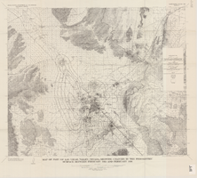
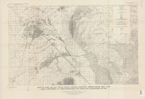
Map of part of Las Vegas Valley, Nevada, showing changes in the piezometric surface between February 1955 and February 1956
Date
1965
Description
Relief shown by contours. Includes township and range lines. Scale 1:96,000 (W 115°30´--W 114°45´/N 36°30´--N 36°00´). Series: Water-supply paper (Washington, D.C.)1780. Originally published as plate 5 of Available water supply of the Las Vegas ground-water basin, Nevada, by Glenn T. Malmberg, published by the Geological Survey in 1965 as its Water-supply paper 1780.
Image
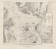
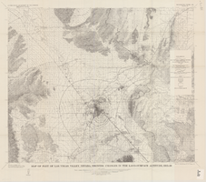
Map of part of Las Vegas Valley, Nevada, showing changes in the piezometric surface between February 1944 and February 1956
Date
1965
Description
Scale 1:62,500 (W 115°15´--W 114°45´/N 36°30´--N 36°00´). 1 map : col. ; 58 x 70 cm. Series: Water-supply paper (Washington, D.C.) ; 1780. Relief shown by contours. Originally published as plate 6 of Available water supply of the Las Vegas ground-water basin, Nevada, by Glenn T. Malmberg, published by the Geological Survey in 1965 as its Water-supply paper 1780. Includes township and range lines. Interior, Geological Survey
Image
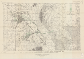
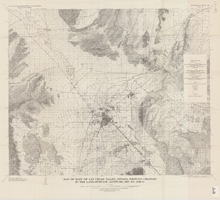
Map of part of Las Vegas Valley, Nevada, showing types, distribution, and approximate areal densities of phreatophytes in 1955
Date
1965
Description
Genre/Form: Thematic maps. Scale 1:62,500 (W 115°15´--W 114°45´/N 36°15´--N 36°00´). 1 map : col. ; 45 x 72 cm. Series: Water-supply paper (Washington, D.C.) ; 1780. Relief shown by contours. Originally published as plate 9 of Available water supply of the Las Vegas ground-water basin, Nevada, by Glenn T. Malmberg, published by the Geological Survey in 1965 as its Water-supply paper 1780. Includes township and range lines. Interior, Geological Survey
Image
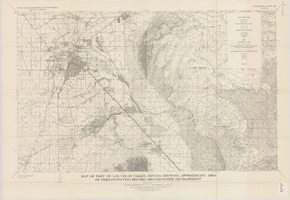
Map of part of Las Vegas Valley, Nevada, showing approximate area of phreatophytes before ground-water development
Date
1965
Description
Genre/Form: Thematic maps. Scale 1:62,500 (W 115°15´--W 114°45´/N 36°15´--N 36°00´). 1 map : col. ; 44 x 72 cm. Series: Water-supply paper (Washington, D.C.) ; 1780. Relief shown by contours. Originally published as plate 10 of Available water supply of the Las Vegas ground-water basin, Nevada, by Glenn T. Malmberg, published by the Geological Survey in 1965 as its Water-supply paper 1780. Includes township and range lines. Interior, Geological Survey
Image
Map of part of Las Vegas Valley, Nevada, showing approximate area and areal densities of phreatophytes and areas in cultivation in 1912
Date
1965
Description
Genre/Form: Thematic maps. Scale 1:62,500 (W 115°15´--W 114°45´/N 36°15´--N 36°00´). 1 map : col. ; 45 x 72 cm. Series: Water-supply paper (Washington, D.C.) ; 1780. Relief shown by contours. Originally published as plate 11 of Available water supply of the Las Vegas ground-water basin, Nevada, by Glenn T. Malmberg, published by the Geological Survey in 1965 as its Water-supply paper 1780. Includes township and range lines. Interior, Geological Survey
Image
Map of part of Las Vegas Valley, Nevada, showing changes in the land-surface altitude, 1935-50
Date
1965
Description
Genre/Form: Topographic maps. Scale 1:96,000 (W 115°30´--W 114°45´/N 36°30´--N 36°00´). 1 map ; 58 x 70 cm. Series: Water-supply paper (Washington, D.C.) ; 1780. Relief shown by contours. "After Smith, Vetter, Cummings, and others (1960, p. 34)." Originally published as plate 13 of Available water supply of the Las Vegas ground-water basin, Nevada, by Glenn T. Malmberg, published by the Geological Survey in 1965 as its Water-supply paper 1780. Includes township and range lines. Interior, Geological Survey
Image
Map of part of Las Vegas Valley, Nevada, showing changes in the land-surface altitude, 1935 to 1940-41
Date
1965
Description
Genre/Form: Topographic map. Scale 1:96,000 (W 115°30´--W 114°45´/N 36°30´--N 36°00´). 1 map ; 58 x 70 cm. Series: Water-supply paper (Washington, D.C.) ; 1780. Relief shown by contours. "After C.R. Longwell (written communication, 1954, fig. 30)." Originally published as plate 12 of Available water supply of the Las Vegas ground-water basin, Nevada, by Glenn T. Malmberg, published by the Geological Survey in 1965 as its Water-supply paper 1780. Includes township and range lines. Interior, Geological Survey
Image

Map of the city of Las Vegas, North Las Vegas, "the Strip," 1960
Date
1960
Description
1960 edition. 41 x 43 cm. Copyright held by Robert E. Barringer. Title in upper-right corner of map: Las Vegas area map. Irregularly-shaped map. Includes index, notes, list of Las Vegas schools and inset maps of East Las Vegas (Whitney) and Wherry housing area on Nellis Air Force Base. Original publisher: Redwood Publishing Co..
Image

Geologic map of the Plutonium Valley quadrangle, Nye and Lincoln counties, Nevada, 1965
Date
1965
Description
58 x 46 cm., on sheet 77 x 83 cm., folded in envelope 30 x 24 cm. Relief shown by contours and spot heights. "Geology mapped in 1961." Includes description of map units, col. cross section, and quadrangle location map. "Prepared in cooperation with the U. S. Atomic Commission." Original publisher: Interior, Geological Survey, Series: Geologic quadrangle map GQ, Scale: 1:24 000.
Image

Geology of the Jackass Flats quadrangle, Nye County, Nevada, 1964
Date
1964
Description
58 x 47 cm., on sheet 86 x 81 cm., folded in envelope 30 x 24 cm. Relief shown by contours and spot heights. "Geology mapped in 1961." Includes description of map units, 2 col. cross sections, and quadrangle location map. "Prepared in cooperation with the U. S. Atomic Commission." Original publisher: Interior, Geological Survey, Series: Geologic quadrangle map GQ, Scale: 1:24 000.
Image