Search the Special Collections and Archives Portal
Search Results
Las Vegas International Hotel, Restaurant & Gaming Show: registration and program, approximately 1990 to 2000
Level of Description
File
Archival Collection
UNLV Libraries Collection of Gaming Research Files
To request this item in person:
Collection Number: MS-00916
Collection Name: UNLV Libraries Collection of Gaming Research Files
Box/Folder: Box 04
Collection Name: UNLV Libraries Collection of Gaming Research Files
Box/Folder: Box 04
Archival Component

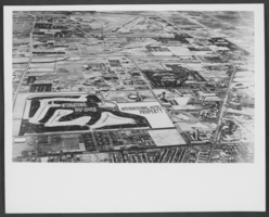
Aerial photograph of central Las Vegas, Nevada, highlighting the property planned for the International Hotel, circa 1966-1970
Date
1966 to 1970
Archival Collection
Description
Aerial photograph of central Las Vegas, with a blank property area planned for the International Hotel. The photograph, looking north to south, covers the area from Sahara Avenue south to McCarran Airport, Maryland Parkway west to the Strip. The following locations are labeled: Nevada Southern University, McCarran Airport, The Tropicana Hotel and Golf Course, the Dunes Hotel and Golf Course, the Flamingo Hotel, Caesars Palace, Castaways, the Sands Hotel, the Frontier Hotel, the Silver Slipper, the Stardust, the Hotel and Golf Course, the Landmark Tower Plaza, the Riviera,the Thunderbird, the Sahara Hotel, El Rancho Las Vegas, the Las Vegas Convention Center, International Golf Course and Hotel property, The Broadway and J.C. Penney's department stores (on the left) and Von Tobels Lumber.
Image
International Hotel accounts receivable, Alex Shoofey personal correspondence, high bills list, 1970 to 1972
Level of Description
File
Archival Collection
Alex Shoofey Papers
To request this item in person:
Collection Number: MS-00858
Collection Name: Alex Shoofey Papers
Box/Folder: Box 20 (Restrictions apply)
Collection Name: Alex Shoofey Papers
Box/Folder: Box 20 (Restrictions apply)
Archival Component
Trump International Hotel & Tower: renderings of exterior and interior building perspectives; floor plans, 2008
Level of Description
File
Archival Collection
Bergman Walls & Associates Architectural Drawings
To request this item in person:
Collection Number: MS-00910
Collection Name: Bergman Walls & Associates Architectural Drawings
Box/Folder: Flat File 22, Digital File 00
Collection Name: Bergman Walls & Associates Architectural Drawings
Box/Folder: Flat File 22, Digital File 00
Archival Component

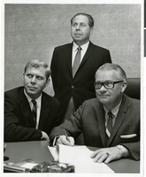
Photograph of Stuart Mason, Morry Mason, and Fred Bennioger meeting to sign a contract for the International Hotel, location unknown, circa 1969
Date
1967 to 1971
Archival Collection
Description
Pictured from left to right: Stuart Mason, Morry Mason, and Fred Bennioger meeting to sign a contract for the International Hotel, location unknown.
Image
Aerial view of central Las Vegas, Nevada, highlighting the property planned for the International Hotel, approximately 1966-1970
Level of Description
File
Archival Collection
Bill Willard Photograph Collection
To request this item in person:
Collection Number: PH-00333
Collection Name: Bill Willard Photograph Collection
Box/Folder: Folder 05
Collection Name: Bill Willard Photograph Collection
Box/Folder: Folder 05
Archival Component
16th Annual Las Vegas International Hotel and Restaurant & Gaming Show: booklet, 1995 June 29
Level of Description
File
Archival Collection
UNLV Libraries Collection of Gaming Research Files
To request this item in person:
Collection Number: MS-00916
Collection Name: UNLV Libraries Collection of Gaming Research Files
Box/Folder: Box 03
Collection Name: UNLV Libraries Collection of Gaming Research Files
Box/Folder: Box 03
Archival Component
Lotus Hill International Hotel and Conference Center: lighting design correspondence, specifications, and notes, 2003 April to 2003 December
Level of Description
File
Archival Collection
John Levy Lighting Productions, Inc. Records
To request this item in person:
Collection Number: MS-00832
Collection Name: John Levy Lighting Productions, Inc. Records
Box/Folder: Box 28
Collection Name: John Levy Lighting Productions, Inc. Records
Box/Folder: Box 28
Archival Component
Various views of the International Hotel and El Casino in Freeport, Grand Bahama Island, Bahamas: postcards, approximately 1940 to 1999
Level of Description
File
Archival Collection
Harvey's Hotel and Casino Postcard Collection
To request this item in person:
Collection Number: PH-00367
Collection Name: Harvey's Hotel and Casino Postcard Collection
Box/Folder: Box 01
Collection Name: Harvey's Hotel and Casino Postcard Collection
Box/Folder: Box 01
Archival Component
Kurup, Ramesh Kanjuli, "An exploratory study of marketing standardization by international hotel companies: Some research propositions", 1993 Spring
Level of Description
Item
Archival Collection
University of Nevada, Las Vegas Theses, Dissertations, and Honors Papers
To request this item in person:
Collection Number: UA-00082
Collection Name: University of Nevada, Las Vegas Theses, Dissertations, and Honors Papers
Box/Folder: Box 085
Collection Name: University of Nevada, Las Vegas Theses, Dissertations, and Honors Papers
Box/Folder: Box 085
Archival Component
Pagination
Refine my results
Content Type
Creator or Contributor
Subject
Archival Collection
Digital Project
Resource Type
Material Type
Place
Language
Records Classification
