Search Results
Aerial image of West Sunset Road and surrounding neighborhoods and commerical properties near Whitney Mesa in Henderson, Nevada: photographic print, approximately 1997 to 2002
Level of Description
Archival Collection
Collection Name: Brian Jones Collection of Henderson, Nevada Aerial Photographs
Box/Folder: Box SH-049
Archival Component
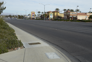
Landscaping and commercial development along Eastern Avenue south of St. Rose Parkway, looking north-northwest in Henderson, Nevada: digital photograph
Date
Archival Collection
Description
From the UNLV University Libraries Photographs of the Development of the Las Vegas Valley, Nevada (PH-00394). Part of the collection documents the entire 19 mile length of the north/south Eastern Avenue / Civic Center Drive alignment. This photograph was captured in the section of Eastern Avenue between Silverado Ranch Boulevard and Coronado Center Drive.
Image
A Five Guys fast food restaurant on Eastern Avenue near Siena Heights Drive, looking south in Henderson, Nevada: digital photograph
Date
Archival Collection
Description
From the UNLV University Libraries Photographs of the Development of the Las Vegas Valley, Nevada (PH-00394). Part of the collection documents the entire 19 mile length of the north/south Eastern Avenue / Civic Center Drive alignment. This photograph was captured in the section of Eastern Avenue between Silverado Ranch Boulevard and Coronado Center Drive.
Image
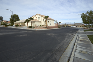
Single family homes in a neighborhood on Riverband Place and Summerchase Lane east of Eastern Avenue, looking west in Henderson, Nevada: digital photograph
Date
Archival Collection
Description
From the UNLV University Libraries Photographs of the Development of the Las Vegas Valley, Nevada (PH-00394). Part of the collection documents the entire 19 mile length of the north/south Eastern Avenue / Civic Center Drive alignment. This photograph was captured in the section of Eastern Avenue between Silverado Ranch Boulevard and Coronado Center Drive.
Image
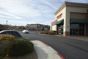
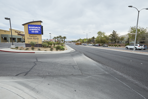
A Shell gas station and commercial center on Sunridge Heights Parkway at Eastern Avenue, looking south-southeast in Henderson, Nevada: digital photograph
Date
Archival Collection
Description
From the UNLV University Libraries Photographs of the Development of the Las Vegas Valley, Nevada (PH-00394). Part of the collection documents the entire 19 mile length of the north/south Eastern Avenue / Civic Center Drive alignment. This photograph was captured in the section of Eastern Avenue between Coronado Center Drive and Sunridge Heights Parkway.
Image
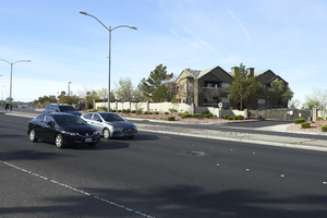
Cars travel on Eastern Avenue north of Sunridge Heights Parkway with an apartment complex, looking south-southwest in Henderson, Nevada: digital photograph
Date
Archival Collection
Description
From the UNLV University Libraries Photographs of the Development of the Las Vegas Valley, Nevada (PH-00394). Part of the collection documents the entire 19 mile length of the north/south Eastern Avenue / Civic Center Drive alignment. This photograph was captured in the section of Eastern Avenue between Coronado Center Drive and Sunridge Heights Parkway.
Image
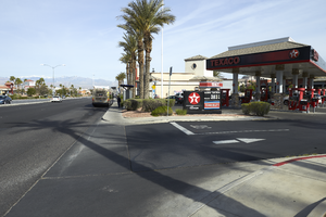
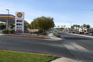
A Texaco gas station near the intersection of Horizon Ridge Parkway and Eastern Avenue, looking north-west in Henderson, Nevada: digital photograph
Date
Archival Collection
Description
From the UNLV University Libraries Photographs of the Development of the Las Vegas Valley, Nevada (PH-00394). Part of the collection documents the entire 19 mile length of the north/south Eastern Avenue / Civic Center Drive alignment. This photograph was captured in the section of Eastern Avenue between Coronado Center Drive and Sunridge Heights Parkway.
Image
Landscaping and commercial development along Eastern Avenue south of Sunridge Heights Parkway, looking north-northwest in Henderson, Nevada: digital photograph
Date
Archival Collection
Description
From the UNLV University Libraries Photographs of the Development of the Las Vegas Valley, Nevada (PH-00394). Part of the collection documents the entire 19 mile length of the north/south Eastern Avenue / Civic Center Drive alignment. This photograph was captured in the section of Eastern Avenue between Sunridge Heights Parkway and Grand Hills Drive.
Image
City of Henderson, Nevada, local improvement district bonds, Green Valley, underwriting proposal from Paine-Webber, Incorporated, 1992 April 06
Level of Description
Archival Collection
Collection Name: Thomas L. Morgan Real Estate Development Records
Box/Folder: Box 26
Archival Component
Final preliminary official statement, City of Henderson, Nevada, 1991 local improvement district, number T-1, Lake Las Vegas, 1992 January 02
Level of Description
Archival Collection
Collection Name: Thomas L. Morgan Real Estate Development Records
Box/Folder: Box 10
Archival Component