Search Results
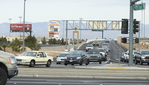
Traffic flows down the Eastern Avenue off-ramp from I-215 The Beltway, looking west in Henderson, Nevada: digital photograph
Date
Archival Collection
Description
From the UNLV University Libraries Photographs of the Development of the Las Vegas Valley, Nevada (PH-00394). Part of the collection documents the entire 19 mile length of the north/south Eastern Avenue / Civic Center Drive alignment. This photograph was captured in the section of Eastern Avenue between Pebble Road and Silverado Ranch Boulevard.
Image
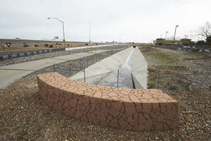
The flood channel and the I-215 East Beltway Trail as seen from Eastern Avenue, looking northeast in Henderson, Nevada: digital photograph
Date
Archival Collection
Description
From the UNLV University Libraries Photographs of the Development of the Las Vegas Valley, Nevada (PH-00394). Part of the collection documents the entire 19 mile length of the north/south Eastern Avenue / Civic Center Drive alignment. This photograph was captured in the section of Eastern Avenue between Pebble Road and Silverado Ranch Boulevard.
Image
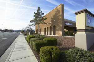
The US Bank building on Eastern Avenue near Coronado Center Drive, looking south-southeast in Henderson, Nevada: digital photograph
Date
Archival Collection
Description
From the UNLV University Libraries Photographs of the Development of the Las Vegas Valley, Nevada (PH-00394). Part of the collection documents the entire 19 mile length of the north/south Eastern Avenue / Civic Center Drive alignment. This photograph was captured in the section of Eastern Avenue between Coronado Center Drive and Sunridge Heights Parkway.
Image
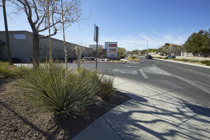
A sign for the Anthem Village Center on Eastern Avenue near Reunion Drive, looking south-southeast in Henderson, Nevada: digital photograph
Date
Archival Collection
Description
From the UNLV University Libraries Photographs of the Development of the Las Vegas Valley, Nevada (PH-00394). Part of the collection documents the entire 19 mile length of the north/south Eastern Avenue / Civic Center Drive alignment. This photograph was captured in the section of Eastern Avenue between Grand Hills and Sun City Anthem Drives.
Image
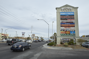
A sign for the Beltway Plaza along Eastern Avenue near Serene Avenue, looking north-northwest in Henderson, Nevada: digital photograph
Date
Archival Collection
Description
From the UNLV University Libraries Photographs of the Development of the Las Vegas Valley, Nevada (PH-00394). Part of the collection documents the entire 19 mile length of the north/south Eastern Avenue / Civic Center Drive alignment. This photograph was captured in the section of Eastern Avenue between Pebble Road and Silverado Ranch Boulevard.
Image
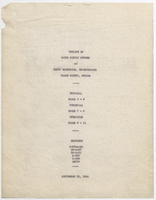
Report, Outline of water supply system at Basic Magnesium, Incorporated, Henderson, Nevada, September 22, 1944
Date
Archival Collection
Description
Detailed report with drawings and maps of the water system at Basic Magnesium, Incorporated.
Text
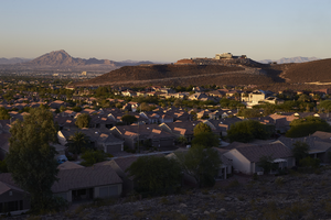
The southwestern edge of the Las Vegas valley as seen from a lot on Soaring Rock Court, looking west, Henderson, Nevada: digital photograph
Date
Archival Collection
Description
Image
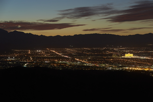
Las Vegas Vally as seen from the City View Trail above Sun City MacDonald Ranch, Henderson, Nevada: digital photograph
Date
Archival Collection
Description
Image
Aerial image of West Sunset Road, surrounding neighborhoods and intersection with East Sunset Road in Henderson, Nevada: photographic print, approximately 1997 to 2002
Level of Description
Archival Collection
Collection Name: Brian Jones Collection of Henderson, Nevada Aerial Photographs
Box/Folder: Box SH-049
Archival Component
Aerial image of commercial building at the intersection of Green Valley Parkway and East Sunset Road in Henderson, Nevada: photographic print, approximately 1997 to 2002
Level of Description
Archival Collection
Collection Name: Brian Jones Collection of Henderson, Nevada Aerial Photographs
Box/Folder: Box SH-049
Archival Component