Search Results
Aerial image of neighborhoods east of Boulder Highway in Henderson, Nevada: photographic print, approximately 1997 to 2002
Level of Description
Archival Collection
Collection Name: Brian Jones Collection of Henderson, Nevada Aerial Photographs
Box/Folder: Box SH-049
Archival Component
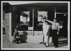
Unidentified persons in front of the Kennedy for President Campaign Headquarters located in Henderson, Nevada: photographic print
Date
Archival Collection
Description
Image
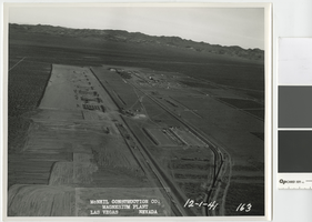
Aerial photograph showing construction activities, Basic Magnesium Inc., Henderson, Nevada, December 1, 1941
Date
Archival Collection
Description
View of construction of the Basic Magnesium Inc. plant from the air looking east.
Transcribed Notes: Transcribed from front of photo: "McNeil construction Co. Magnesium plant, Las Vegas, Nevada, 12-1-41"
Image
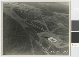
Aerial photograph showing Henderson, Nevada and the Basic Magnesium Inc. plant, March 31, 1942
Date
Archival Collection
Description
Aerial view of Henderson and the Basic Magnesium plant showing the terminal reservoir, demountable housing, and temporary boarding camp.
Image
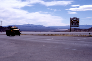
Railroad Pass Casino monument and flag mounted pylon signs, Henderson, Nevada: photographic print
Date
Archival Collection
Description
Exterior views of the Railroad Pass Casino in Henderson, NV during the day.
1500 Railroad Pass Casino Rd, Henderson, NV 89002
Image
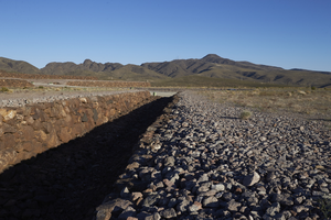
Flood control ditch along Cloudrock Court in Ascaya development prior to home construction, Henderson, Nevada: digital photograph
Date
Archival Collection
Description
Image
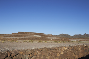
Flood control ditch along Cloudrock Court in Ascaya development prior to home construction, Henderson, Nevada: digital photograph
Date
Archival Collection
Description
Image
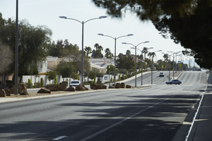
Looking east up Windmill Lane east of Eastern Avenue, in Henderson, Nevada: digital photograph
Date
Archival Collection
Description
From the UNLV University Libraries Photographs of the Development of the Las Vegas Valley, Nevada (PH-00394). Part of the collection documents the entire 19 mile length of the north/south Eastern Avenue / Civic Center Drive alignment. This photograph was captured in the section of Eastern Avenue between Windmill Parkway and Pebble Road.
Image
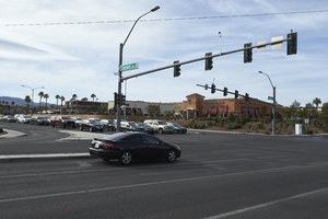
The intersection of Eastern Avenue and Coronado Center Drive, looking south in Henderson, Nevada: digital photograph
Date
Archival Collection
Description
From the UNLV University Libraries Photographs of the Development of the Las Vegas Valley, Nevada (PH-00394). Part of the collection documents the entire 19 mile length of the north/south Eastern Avenue / Civic Center Drive alignment. This photograph was captured in the section of Eastern Avenue between Silverado Ranch Boulevard and Coronado Center Drive.
Image
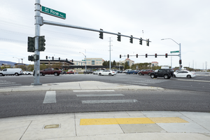
The intersection of Eastern Avenue and St. Rose Parkway, looking south in Henderson, Nevada: digital photograph
Date
Archival Collection
Description
From the UNLV University Libraries Photographs of the Development of the Las Vegas Valley, Nevada (PH-00394). Part of the collection documents the entire 19 mile length of the north/south Eastern Avenue / Civic Center Drive alignment. This photograph was captured in the section of Eastern Avenue between Silverado Ranch Boulevard and Coronado Center Drive.
Image