Search Results
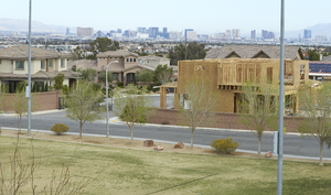
A single family home under construction next to Cactus Wren Park as seen from the Amargosa Pedestrian Bridge on St. Rose Parkway, east of Eastern Avenue, looking southwest in Henderson, Nevada: digital photograph
Date
Archival Collection
Description
From the UNLV University Libraries Photographs of the Development of the Las Vegas Valley, Nevada (PH-00394). Part of the collection documents the entire 19 mile length of the north/south Eastern Avenue / Civic Center Drive alignment. This photograph was captured in the section of Eastern Avenue between Silverado Ranch Boulevard and Coronado Center Drive.
Image
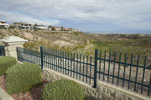
Custom homes along a ridge above the Rio Secco Golf Course with Las Vegas in distance as seen from Grand Hills Drive and Eastern Avenue, looking north-west in Henderson, Nevada: digital photograph
Date
Archival Collection
Description
From the UNLV University Libraries Photographs of the Development of the Las Vegas Valley, Nevada (PH-00394). Part of the collection documents the entire 19 mile length of the north/south Eastern Avenue / Civic Center Drive alignment. This photograph was captured in the section of Eastern Avenue between Sunridge Heights Parkway and Grand Hills Drive.
Image
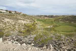
Custom homes along a ridge above the Rio Secco Golf Course with Las Vegas in distance as seen from Grand Hills Drive and Eastern Avenue, looking north-west in Henderson, Nevada: digital photograph
Date
Archival Collection
Description
From the UNLV University Libraries Photographs of the Development of the Las Vegas Valley, Nevada (PH-00394). Part of the collection documents the entire 19 mile length of the north/south Eastern Avenue / Civic Center Drive alignment. This photograph was captured in the section of Eastern Avenue between Sunridge Heights Parkway and Grand Hills Drive.
Image
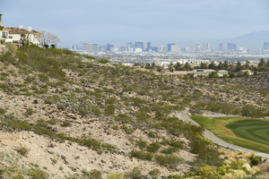
Custom homes along a ridge above the Rio Secco Golf Course with Las Vegas in distance as seen from Grand Hills Drive and Eastern Avenue, looking north-west in Henderson, Nevada: digital photograph
Date
Archival Collection
Description
From the UNLV University Libraries Photographs of the Development of the Las Vegas Valley, Nevada (PH-00394). Part of the collection documents the entire 19 mile length of the north/south Eastern Avenue / Civic Center Drive alignment. This photograph was captured in the section of Eastern Avenue between Sunridge Heights Parkway and Grand Hills Drive.
Image
The Pittman Pecos Conveyance and the Cactus-Wren Trail wind around a commercial development and an undeveloped parcel on Candelaria Street off Eastern Avenue, looking south-southwest in Henderson, Nevada: digital photograph, 2019 March 27
Level of Description
Archival Collection
Collection Name: UNLV University Libraries Photographs of the Development of the Las Vegas Valley, Nevada
Box/Folder: N/A
Archival Component
Runners jog on the I-215 East Beltway Trail along a flood control channel as seen from Eastern Avenue at the I-215 The Beltway intersection, looking east-northeast in Henderson, Nevada: digital photograph, 2019 March 27
Level of Description
Archival Collection
Collection Name: UNLV University Libraries Photographs of the Development of the Las Vegas Valley, Nevada
Box/Folder: N/A
Archival Component
Custom homes surround an undeveloped lot as seen from Sun City Anthem Drive west of Eastern Avenue with Las Vegas skyline in background, looking west in Henderson, Nevada: digital photograph, 2019 April 03
Level of Description
Archival Collection
Collection Name: UNLV University Libraries Photographs of the Development of the Las Vegas Valley, Nevada
Box/Folder: N/A
Archival Component
A block wall and emergency access road separates single family housing from a commercial development on Eastern Avenue north of Sunridge Heights Parkway, looking east in Henderson, Nevada: digital photograph, 2019 April 01
Level of Description
Archival Collection
Collection Name: UNLV University Libraries Photographs of the Development of the Las Vegas Valley, Nevada
Box/Folder: N/A
Archival Component
Undeveloped land below custom homes and the Rio Secco Golf Club as seen from Pecos Ridge Parkway west of Eastern Avenue, looking south-southwest in Henderson, Nevada: digital photograph, 2019 April 02
Level of Description
Archival Collection
Collection Name: UNLV University Libraries Photographs of the Development of the Las Vegas Valley, Nevada
Box/Folder: N/A
Archival Component
Large power transmission lines cut through a heavy commercial and multi-family housing area near Eastern Avenue and Coronado Center Drive, looking southwest in Henderson, Nevada: digital photograph, 2019 March 28
Level of Description
Archival Collection
Collection Name: UNLV University Libraries Photographs of the Development of the Las Vegas Valley, Nevada
Box/Folder: N/A
Archival Component