Search Results
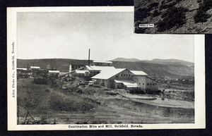
Postcard of the Combination Mine and Mill, Goldfield (Nev.), 1900-1920
Date
1900 to 1920
Archival Collection
Description
Caption: Combination Mine & Mill, Goldfield, Nevada
Image

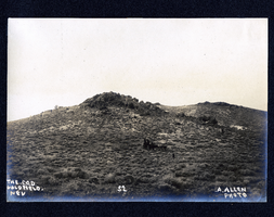
Photograph of men working at the Red Top Mine, Goldfield (Nev.), early 1900s
Archival Collection
Description
Caption: The new strike on the red top. Goldfield
Image
Photograph of horses and carriage on hillside in Goldfield (Nev.), early 1900s
Archival Collection
Description
Caption: The C.O.D. Goldfield. Nev 52
Image
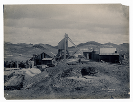
Photograph of Combination Mine, Goldfield (Nev.), early 1900s
Archival Collection
Description
Caption: Combination
Image
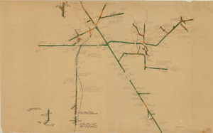
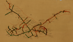
Map of the 380 foot level of the Combination Mine, Goldfield, Nevada, circa 1902-1908
Date
1902 to 1908
Description
'380 ft. level.' Hand-drawn, hand-colored and annotated map showing the 380 foot level of the Combination Mine.
Image

Map of the 328 foot level of the Combination Mine, Goldfield, Nevada, circa 1902-1908
Date
1902 to 1908
Description
Hand-drawn, hand-colored and annotated map showing the 328 foot level of the Combination Mine.
Image
Map of the 130 foot level of the Combination Mine, Goldfield, Nevada, circa 1902-1908
Date
1902 to 1908
Description
'130 ft. level. Combination Mine.' 'Scale 1 in.=40 ft.' Hand-drawn, hand-colored and annotated map showing the 130 foot level of the Combination Mine.
Image
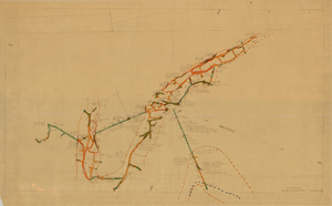
Map of the 330 foot level of the Combination Mine, Goldfield, Nevada, circa 1902-1908
Date
1902 to 1908
Description
Hand-drawn, hand-colored and annotated map showing the 330 foot level of the Combination Mine.
Image
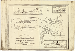
Map of the properties of the Tonopah Extension, Pittsburg Tonopah, Golden Anchor, and Red Rock Consolidated Mining Companies : Tonopah Mining District, Nye County (Nev.), 1901
Date
1901
Description
Scale [ca. 1:2,400] 1 in. to 200 feet ; 1 map ; 75 x 102 cm; Includes locations of mines and their main shafts and drawings of the hoists of the Tonopah Extension, Golden Anchor and the Red Rock Consolidated ; Photocopy. [United States : s.n., 198-?]
Image
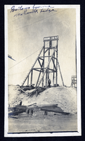
Photograph of Mohawk Ledge Mine gallows frame, Goldfield (Nev.), early 1900s
Date
1900 to 1925
Archival Collection
Description
Caption: Gallows frame Mohawk Ledge
Image