Search Results

Aerial photograph of Sunrise Mountain and Nellis AFB area, circa 1949
Date
Archival Collection
Description
Sunrise Mountain and Nellis AFB area looking east.
Transcribed Notes: Transcribed from handwritten notes on back: "View SE. In foreground, large fan S.E. of Nellis Air Force"
Image
Las Vegas Ranch well log, circa October 2, 1939
Date
Archival Collection
Description
Well drilling log for a well drilled on the Las Vegas Ranch
Text
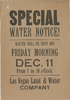
Handbill announcing water outage, Las Vegas, December 11, 1925
Date
Archival Collection
Description
Notice that the water would be shut off on 11 December 1925 from 7 to 10 a.m.
Text

Letter from Walter R. Bracken (Las Vegas) to J. Ross Clark, February 15, 1912
Date
Archival Collection
Description
Well No. 1 had just been completed and Bracken advised Clark that they would need to keep an eye on the flow from the Big Spring to see if the new well had an effect on the water flow.
Text

Photograph of I. ''Pat'' Head, Oran Gragson, and Leonard Fayle at reservoir construction site, May 1, 1969
Date
Archival Collection
Description
Oran Gragson, Leonard Fayle, and I. ''Pat'' Head at the Leonard R. Fayle reservoir construction site. Left to Right: I. 'Pat' Head, Mayor Oran Gragson, and Leonard R. Fayle.
Image

Aerial photograph of Las Vegas looking northwest, late 1950s
Date
Archival Collection
Description
Aerial view of Las Vegas looking northwest. Fremont Street in center, running west.
Transcribed Notes: Notes on photo sleeve: Aerial view of Las Vegas looking west. Fremont Street in center, running west.
Image
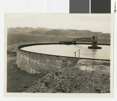
Photograph of water clarifier tank at gravel plant in Hoover Dam construction, March 19, 1932
Date
Archival Collection
Description
Water clarifier tank at the gravel plant by the Colorado River for Hoover Dam construction.
Transcribed Notes: Handwritten on back: [1038], 3-19-32; Notes on photo sleeve: Water clarifier tank at the gravel plant. The water is pumped from the river two miles away and is distilled in this tank. March 19, 1932.
Image
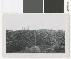
Photograph of pondwater overflow at Whitney Ranch, circa 1950
Date
Archival Collection
Description
Overflow from a pond that was constructed to catch rain water on the Whitney Ranch.
Transcribed Notes: Handwritten collection note on back: overflow from pond handmade; Notes on photo sleeve: 'Overflow from pond (handmade) at Whitney Ranch. Pond was constructed to catch rainwater.'
Image

Aerial photograph of Las Vegas looking south, 1930
Date
Archival Collection
Description
Aerial view of Las Vegas in 1930.
Transcribed Notes: Notes on photo sleeve: 'Shows stockyards and car shops. Creek is overflow from UP artesian well. Site of earliest ranch in area. Creek had mosquito minnows in it - a native species. Only source of water for Las Vegas. Water carried in a 20-24'' wooden pipe.' (James J. Hester, from W.A. Davis, photographer. April 1992)
Image
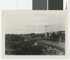
Photograph of road washout five miles southeast of Las Vegas, circa 1931
Date
Archival Collection
Description
Washout at 4-mile on the Boulder Highway, about 5 miles southeast of Las Vegas.
Transcribed Notes: Notes on photo sleeve: 'New pavement finished in May. Cloudburst in October took out culvert. Took out a Chevrolet and a Packard. About 5 mi. southeast of Las Vegas.' (James J. Hester, quote from W.A. Davis)
Image