Search Results

Letter from Walter R. Bracken (Las Vegas) to F. H. Knickerbocker (Los Angeles) July 25, 1928
Date
Archival Collection
Description
Walter R. Bracken of the Las Vegas Land and Water Co. approved of Knickerbocker's decision for the Union Pacific Railroad to provide Bishop Earl with water from Overton.
Text
Letter from Walter R. Bracken (Las Vegas) to C. J. Balch (Los Angeles), October 20, 1913
Date
Archival Collection
Description
Bracken notifying the Union Pacific Railroad that the water situation on the Stewart burial plot was satisfactory.
Text
Purchase offer from Las Vegas Valley Water District to purchase all water production lands and facilities owned by the Union Pacific Railroad and subsidiaries, January 31, 1953
Date
Archival Collection
Description
Offer from the Las Vegas Valley Water District to Union Pacific Railroad Company, Los Angeles and Salt Lake Railroad Company, and Las Vegas Land and Water Company, to purchase all water production lands and facilities owned by the Union Pacific Railroad and subsidiaries. The offer was sent to the attention of Mr. William Reinhardt, Vice President.
Text

Aerial photograph of Las Vegas, partial view of high school, southwest direction, 1930
Date
Archival Collection
Description
Aerial view of Las Vegas in 1930
Transcribed Notes: Handwritten collection note on back of photo: Aerial view of Las Vegas showing Fifth St. and Main St., c. 1933; Notes on photo sleeve: Aerial view of Las Vegas 'taken in a clip wing Jenny. Date is winter of 1930. Plane had a wooden propeller open cockpit. Pilot had a contract with Bureau of Reclamation to fly aerial photos in a grid. Took Wint (up in) the plane this day because it was too windy (for the pilot) to take his regular aerials.' (James J. Hester, son-in-law of W.A. Davis ('Wint'), the photographer who took this. Note added 4-92.
Image
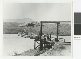
Photograph of Cottonwood Aerial Ferry, 1930-1935
Date
Archival Collection
Description
Cottonwood Aerial Ferry carried customers between Searchlight, Nevada and Chloride, Arizona. It is now under Lake Mohave. Sign with ferry rates: Car $2.00, Truck $2.50, Motorcycle $1.00, Horseman .50, Stock .50, Pedestrian .25
Transcribed Notes: Transcribed from photo sleeve: "Cottonwood Aerial Ferry, from about 1930-1935. This was the last and the most unusual of several ferries that crossed at Cottonwood between Searchlight, Nev. and Chloride, Ariz., these being the two major towns in the area before 1920. Most were conventional barge types similar to the Arivada Ferry shown in another picture. The aerial ferry was powered by an automobile engine mounted on the upper framework, with the operator up with the engine. It was located at the mouth of Painted Canyon, a short distance upriver from the Cottonwood Cove Resort. Courtesy Ella Kay."
Image
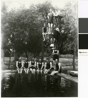
Group photograph of men in swim wear at the Las Vegas Ranch, 1916
Date
Archival Collection
Description
Group of swimmers at the Lake Vegas Ranch with the ruins of the Mormon Fort in the background. Information provided by Special Collections included a photocopy of the photograph identifying three of the individual in the photograph. The second person from the top, on the left, is Robert Griffith. The fourth person down (standing) is Otto "Kelly" Westlake. The man sitting directly in front of Westlake is Jay Warren Woodard.
Transcribed Notes: Transcribed from photo sleeve: "Group at the old ranch - just north of the present Elks club. Group was mainly railroad employees, the picture was taken in 1916. [Identified are] Robert Griffith - (his dad, T. W. Griffith, developed the Mt. Charleston resort area.) Robert was chairman of the Colorado River Commission.; Otto "Kelly" Westlake (Kelly is a nickname); Jay Warren Woodward had the first Chevrolet agency."
Image
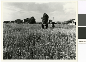
Photograph of Gordon Bettles and unknown men in a rye field on the T & T Ranch, Nevada, 1949
Date
Archival Collection
Description
Gordon Bettles and two others inspecting the rye in preparation for cutting it on the T & T Ranch in the Amargosa Valley.
Transcribed Notes: Transcribed from photo sleeve: "Inscription on the back of the original photo, written by Billie Bettles in the 1980s reads: this [picture] was made the day they were cutting rye, 1949. House and outbuildings were constructed by Gordon Bettles on the T & T Ranchk, Amargosa Valley, NV, about 1949. The house pictured on the right was moved to this location from Death Valley Junction, California, by the Bettles. A field of rye is pictured in the foreground. The man on the right is Gordon Bettles and the 2 men on the left are unidentified, though the man on the far left may be M. P. 'Gless' Glessner."
Image

Photograph of John Quincy Lisle at the edge of his reservoir, Las Vegas, circa 1930
Date
Archival Collection
Description
Lisle stands at the edge of the reservoir fed by an artesian well on his homestead.
Transcribed Notes: Transcribed from photo sleeve: "John Quincy "Jack" Lisle at the edge of the reservoir on his homestead in the Las Vegas Valley, about 1930. The reservoir is located not far from the present intersection of Twain and Eastern streets and was one of the best artesian wells in the Las Vegas Valley. At the time it was necessary to make a winding road off the Boulder Highway to reach the homestead. Most people thought that Lisle was absolutely insane to locate a homestead in such a desolate place, but Lisle, and amateur geologist, staked his claim there because he figured that water would be abundant because the land was near the Flamingo Wash. At one time Lisle raised 40 acres of alfalfa on the property."
Image
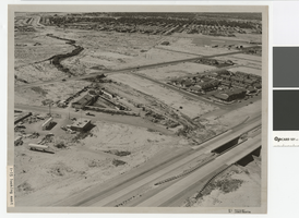
Aerial photograph of North Las Vegas flood control channel under I-15 and Civic Center Drive, June 5, 1973
Date
Archival Collection
Description
Flood control channel crossing I-15 and Civic Center Drive, Bullock's Feed and Tack store nearby.
Transcribed Notes: Notes from photo sleeve: "Aerial photo: Looking southeast. North Las Vegas flood control channel crosses I-15 and Civic Center Drive with Bulloch's Feed and Tack store next to channel. June 5, 1973." Stamped on back: "CNLV Engineering Dept." Notes on back: "Looking SE NLV Flood Control channel crosses I-15 and Civic Center Drive with Bullocks Feed and Tack store next to channel"
Image

Mounted photographs of William McGruff and Old Man Mason near an artesian well, and William McGruff and his peach trees, Las Vegas, circa 1915
Date
Archival Collection
Description
William McGuff (right) and Old Man Mason (left) near an artesian well at the McGruff Ranch. Old Man Mason who brought the first automobile to town. Two photographic prints mounted on one piece of cardboard. It was verified that Paradise Road and Sur Este Avenue are in Las Vegas.
Transcribed Notes: Transcribed from cardboard mount (below first photo): "William McGruff Ranch. Man in dark clothes is 'Old Man Mason' who brought first auto to town."; Transcribed from second photo: "Mr. McGruff & his peach trees." and "Paradise Rd. on Sur Este Ave."
Image