Search Results
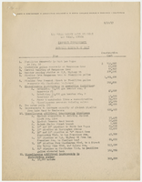
Proposed improvements and costs of Las Vegas Valley Water District listed by James M. Montgomery (Pasadena, California), August 19, 1953
Date
Archival Collection
Description
Detailed list by a consulting engineer itemizing costs of proposed improvements by the Las Vegas Valley Water District after the change in ownership of the Las Vegas water facilities.
Text
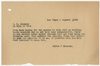
Letter from Walter R. Bracken (Las Vegas) to R. L. Adamson, August 5, 1936
Date
Archival Collection
Description
Bracken had been trying for months to get the roof over a reservoir at the springs repaired, and now a dead rabbit had been found in the pool.
Text

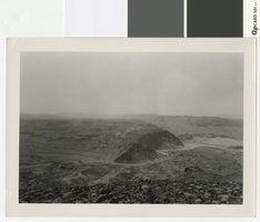
Aerial photograph of the Las Vegas Valley looking northwest towards Mount Charleston, 1945
Date
Archival Collection
Description
Aerial view of the Las Vegas Valley looking northwest towards Mount Charleston.
Transcribed Notes: Handwritten inscription on back: Las Vegas about 1945 looking toward Charleston Mountains (North West). Road intersection in immediate foreground is that of Fremont Street from the right, Charleston Blvd from the left (Charleston Blvd runs due West); Stamped on back: Las Vegas News Bureau, Las Vegas - Nevada, Photographers Don English - Joe Buck - Jerry Abbott
Image
Photograph looking west over the Colorado River and Hemenway Wash from Fortification Hill, before 1931
Date
Archival Collection
Description
Looking west over the Colorado River and Hemenway Wash from Fortification Hill.
Transcribed Notes: Handwritten collection note on back of photo: [Las Vegas Wash and area under water now(?)]; Notes on photo sleeve: [Las Vegas Wash area] from top of Fortification Mountain. (Credit: W.A. Davis); 'Wint made a fire at night on top then kicked it off into space. Lacey hired Wint to do it for some tourists.' - James J. Hester, son-in-law of W.A. ('Wint') Davis, 1992
Image
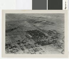
Aerial photograph of Las Vegas, full view of high school, southwest direction, 1930
Date
Archival Collection
Description
Aerial view of Las Vegas in 1930
Transcribed Notes: Notes on back of duplicate photo: Aerial view of Las Vegas w/ new high school on bottom left, c. 1933; Notes on photo sleeve: Aerial view of Las Vegas taken in the winter of 1930 (same day as #0123 002) in clip wing Jenny. Shows railroad and main street - essentially shows the whole city. (Credit: W.A. Davis)
Image
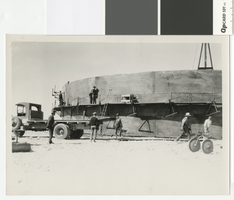
Photograph of water storage tank construction in Boulder City, circa 1931
Date
Archival Collection
Description
Construction of a water tank in Boulder City by the Clearfire Water Company.
Transcribed Notes: Notes on photo sleeve: 'Hill leveled with dynamite before building tank - Clearfire Water Co. Water came into booster plant from river. Dumps at river were on inclined steel rails and went up and down with water level. Then went from booster plant to clarification station, then on to this storage tank.' (W.A. Davis)
Image
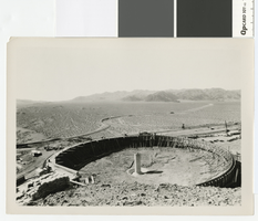
Photograph of settling basin at the head of Hemenway Wash for water purification works in Boulder City, circa 1931
Date
Archival Collection
Description
Settling basin at the head of Hemenway Wash for water purification works in Boulder City.
Transcribed Notes: Stamped on back of photo: Photograph by W. A. Davis Box 1169, Las Vegas, Nevada; Notes on photo sleeve: [Setting basin for making concrete. Upstream from the Dam about 5-10 miles. R.R. track may have crossed over to Arizona.] Photographer W.A. Davis disagrees: says this is part of a water purification plant; the settling basin shown purifies water. (documentation, 4/92)
Image
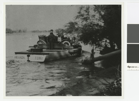
Photograph of the Arivada Ferry, 1916-1920
Date
Archival Collection
Description
Arivada Ferry, owned by Jim Cashman and operated by Pop Emery. Its primary purpose was to provide a way for Arizonans to get to Nevada where prohibition was not as strictly enforced.
Transcribed Notes: Transcribed from photo sleeve: "Arivada Ferry, 1916-1920. This ferry was owned by Jim Cashman and operated by Pop Emery (standing, in picture). Originally located at the upper end of Cottonwood Island, a few miles below where the Cottonwood Cove Resort is located, it was later moved due to lack of business to TriState, Nevada, where it served for a short time between the Katherine Mine in Arizona and the TriState Mine in Nevada. Its main purpose here was to provide a way for Arizonans to get to Nevada where prohibition laws were not strictly enforced."
Image

Photograph of a drill rig putting down the hole for the first well in the Las Vegas Heights District, circa 1907
Date
Archival Collection
Description
Drilling in the Las Vegas Heights District with Mr. Booth and Mr. Madison performing the work.
Transcribed Notes: Transcribed from front of photo: "1st well. Vegas Hts. About 1907. Booth & Madison, Drillers."; Transcribed from photo sleeve: "A drill rig which put down the hole for the first well in the Las Vegas Heights District in Las Vegas in 1907. The crew were Booth and Madison."
Image
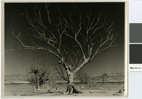
Photograph of two women posing on a giant dead Cottonwood tree in the remains of St. Thomas, 1945
Date
Archival Collection
Description
Two women on the trunk of a very large dead Cottonwood tree in the remains of St. Thomas
Transcribed Notes: Transcribed from photo sleeve: "This is one of the oldest trees in this section and was covered by nearly 70 feet of water (Lake Mead) for about seven years. The height may be compared by the two girls on the trunk of the tree."
Image