Search Results
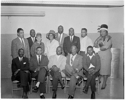
Set of photographs including NAACP installation (1965), and Human Relation Commission: image 006
Date
Archival Collection
Image

Set of photographs of Golden Western Shopping Center shops: image 001
Date
Archival Collection
Image
topographic maps
Refers to maps representing a region at a level of detail or scale between a plan, which is a small area, and a chorographic map, which is a large regional map. Topographic maps include accurate representations of the location and shape of both natural and manmade features. The term refers to maps of various scales in different nations; it is generally limited to maps at scales of 1:500,000 or larger in the United States, but it often refers to scales of 1:1,000,000 or larger in Russia. The term is often mistakenly interpreted to mean maps that only represent natural relief features.
Material Type


Set of photographs of the St. Paul Church dedication
Date
Archival Collection
Description
Photographer's notations: St. Paul Church Dedication 3-19-67. Some photos from this set were previously online with the digital ID pho023795.
Image
Joint Use Agreement with Rocky Mountain Produce Company to provide access to the Las Vegas Paiute Colony
Date
Archival Collection
Description
Joint Use Agreement signed by Rocky Mountain Produce Company providing for recognized road access to the Las Vegas Indian (Paiute) Colony. Includes a map and related Bureau of Indian Affairs correspondence.
Text