Search Results

Topographic map of Cane Spring, Nevada quadrangle, 1961
Date
1961
Description
'Mapped, edited and published by the Geological Survey in cooperation with the Atomic Enegry Commission. Control by USGS, USC&GS, USCE, and Atomic Energy Commission. Topography from aerial photographs by photogrammetric methods. Aerial photographs taken 1959. Field check 1961.' Scale 1:24,000 polyconic projection (W 116°07'30"--W 116°00'00"/N 36°52'30"--N 36°45'00"). Series: 7.5 minute series (topographic). Relief shown by contours and spot heights. Contour interval 20 feet. Includes quadrangle location map. Interior--Geological SurveyFor sale by the U.S. Geological Survey
Image
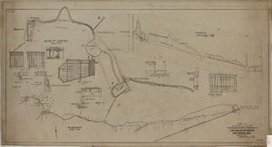
Map showing proposed improvement of Las Vegas Springs, Las Vegas, Nevada, September 21, 1916
Date
1916-09-21
Description
'Exhibit A'. 'Approved Sept. 21, 1916.' 'W.E.J.'"--Lower left corner. 'L-44-50 to 61. T-75 - 17 & 46'--Upper left corner. Includes discharge figures and plans for improvements to springs Scale [ca. 1:240]. 1 in. to 20 feet. -- Scale [ca. 1:2,400]. 1 in. to 200 ft. Vertical scale [ca. 1:48]. 1 in. to 4 feet. -- Scale [ca. 1:4,800]. 1 in. to 100 feet. Library's copy has "Proposed layout" written on it in pencil near lower center and other markings in red. Contents: Detail at springs -- Profile -- Alignment.
Image
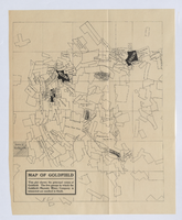
Map of Goldfield, circa 1904-1908
Date
1900 to 1912
Description
'This plat shows the principal mines of Goldfield. The five groups in which the Goldfield-Majestic Mines Company is interested are marked in black.'
Image
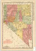
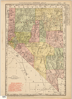
Map showing railroads in Nevada, 1904
Date
1904
Description
Relief shown by hachures. Added title: Rand McNally's new business map of Nevada. Shows range and township grid. Shows railroads. Color used to show boundaries of counties. Includes index to cities. On verso: Indexes to counties, lakes, mountains, rivers, towns, etc. Published by Rand McNally & Co. Scale [ca. 1:1,710,720]. 1 in. equals 27 miles (W 120°--W 114°/N 42°--N 35°). Originally published as pages 263 and 264 of Rand-McNally indexed atlas.
Text


Map showing railroads in Nevada, 1911
Date
1911
Description
Relief shown by hachures. Title below scale: Rand McNally & Co.'s New business atlas map of Nevada. Shows railroads. Includes township and range grid. Includes index to principal cities with population statistics. Includes township and range grid. Index to Nevada counties, lakes, mountains, rivers, towns, etc. on verso. Published by Rand McNally & Co. Scale [ca. 1,710,720]. 1 in. = 27 miles (W 120°--W 114°/N 42°--N 35°). Published as page 321 of Rand-McNally indexed atlas.
Text
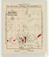
Map of the Bullfrog Mining District, Nye County, Nevada, circa 1905
Date
1901 to 1909
Description
At top of map: 'Compliments of the Forward Mining Development Co.' On left and right margins: 'The Patrick Investment Company, Fiscal Agents.' At bottom of map: '19 Toltec Block, Denver, Colorado.' 'The Williamson-Haffner Co., Denver.' Relief shown by hachures. Properties owned by Patrick Investment Company are marked in red. Shows railroads, roads, and pipelines. Scale [ca. 1:39,000. 1 in. to approx. 3,250 feet].
Image