Search Results
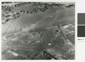
Aerial photograph of Downtown Henderson looking south towards Railroad Pass, circa 1963
Date
Archival Collection
Description
Aerial view of Henderson looking south towards Railroad Pass
Transcribed Notes: Transcribed from photo sleeve: "Aerial view of Downtown Henderson, NV"
Image
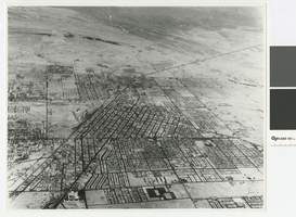
Aerial photograph of Las Vegas looking north, circa 1963
Date
Archival Collection
Description
Aerial view of Las Vegas looking north
Transcribed Notes: Transcribed from photo sleeve: "Aerial view of Las Vegas"
Image
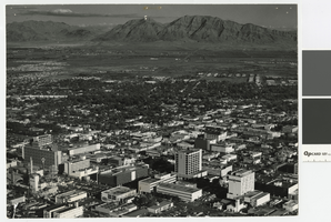
Aerial photograph of downtown Las Vegas looking east toward Frenchman Mountain, post-1953
Date
Archival Collection
Description
Aerial view of downtown Las Vegas looking east toward Frenchman Mountains. The following buildings are visible in the photograph: Lucky Casino, Horseshoe Casino, Fremont Hotel and Casino, Four Queens Casino, Golden Nugget, El Cortez Hotel, First National Bank, Bank of Nevada.
Transcribed Notes: Transcribed from photo sleeve: "Aerial view of Downtown Las Vegas"
Image
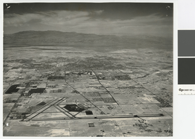
Aerial photograph of Las Vegas looking north, circa 1974
Date
Archival Collection
Description
Aerial view of Las Vegas looking north. The Strip, Paradise Road, and UNLV are visible in the photograph.
Transcribed Notes: Transcribed from photo sleeve: "Aerial view landing strip, Las Vegas Airport, 3-16-70"
Image
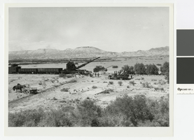
Photograph of Union Pacific Railroad crews removing tracks at the St. Thomas line, 1938
Date
Archival Collection
Description
Union Pacific Railroad crews taking up the St. Thomas line in advance of Lake Mead.
Transcribed Notes: Transcribed from photo sleeve: "Taking up track, advancing waters of Lake Mead in background"
Image
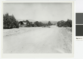
Photograph of crew dismantling a house in St. Thomas, 1938
Date
Archival Collection
Description
Crew dismantling a house in St. Thomas
Transcribed Notes: Transcribed from photo sleeve: "Tearing down a house in St. Thomas, NV"
Image
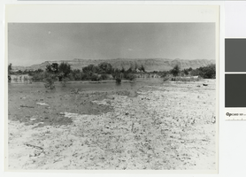
Photograph of advancing waters of Lake Mead through St. Thomas, 1938
Date
Archival Collection
Description
A view of the advancing waters of Lake Mead through St. Thomas.
Image

Photograph of flooded street in Saint Thomas, Nevada, June 1938
Date
Archival Collection
Description
A shack on fire, probably Hugh Lords', in Saint Thomas flooding.
Image

Photograph of advancing waters of Lake Mead, Nevada, 1938
Date
Archival Collection
Description
Looking east at Hugh Lords' garage and the Valley of Fire from the advancing waters of Lake Mead.
Image

Photograph of Main Street after Lake Mead receded, Saint Thomas, Nevada, April 18, 1951
Date
Archival Collection
Description
Saint Thomas on the Muddy River, upper arm of Lake Mead, shows appearance of old Main Street after the lake had gone down, April 18, 1951. Lake Mead is in the background.
Image