Search Results
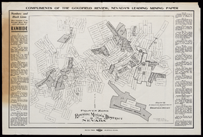
Map of Rawhide Mining District, Nevada, circa 1908
Date
1905 to 1911
Description
'Numbers and black lines show locations of the principal mines, prospects and leases of Rawhide.' 'Compiled by Engraving Department of the Goldfield Review. Olmstead and Rich, Mining Engineers, Goldfield, Nevada.' At top of map: 'Compliments of the Goldfield Review, Nevada's leading mining paper.' Includes index. Published by Goldfield Review Press.
Text

Map of Las Vegas Valley, Clark County, Nevada, 1954
Date
1954
Description
Scale [ca. 1:63,360. 1 in. to approx. 5,280 ft.].Cadastral map. 'Compiled for C.D. Baker, Reg. Civil Engineer Nevada No. 6 and Licensed Real Estate Broker by Tyson Engineering Co., Las Vegas, Nevada.' 'Copyright 1954 Tyson Engineering Co., Las Vegas, Nevada. Drawn by E.M. Ballinger' Tyson Engineering Company
Image
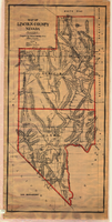
Map of Lincoln and Clark Counties, Nevada, 1908
Date
1908
Description
'Map of Lincoln County, Nevada. Compiled by H.E. Freudenthal from official surveys. Copyright, 1908, by H.E. Freudenthal.' Relief shown by hachures and spot heights. Shows range and township grid. Shows towns, railroads, proposed railroads, wagon roads and springs. Scale [ca. 1:380,160]. 1 in. to approx. 6 miles (W 116°--W 114°/N 39°--N 35°).
Image

Map of city of Las Vegas, Nevada, October 1, 1940
Date
1940-10-01
Description
'Compiled by C.D. Baker, Oct. 1, 1940.' Scale [ca. 1:11,400]. 1 in. to 950 ft. Cadastral map.
Image
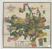
Map of Tonopah Mining District, Nevada, 1905
Date
1905
Description
In lower right corner: 'Copyrighed by Bradford & Bradford 1905.' Includes table of distances from Tonopah. Relief shown by hachures. Scale [ca. 1:15,600. 1 in. to approx. 1300 feet]. Library's copy has one section outlined in red pencil and 'Tonopah Victor' hand-printed on it in red pencil. Red pencil dots are on two other sections. '1905' and some illegible words written in pencil near title of map.
Image
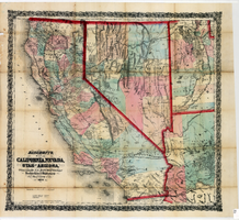
Bancroft's map of California, Nevada, Utah and Arizona, 1873
Date
1873
Description
Hand colored ; Relief shown by hachures and spot heights ; Prime meridian: Washington, D.C ; Shows railroads, proposed railroads and wagon roads, etc. Published by A.L. Bancroft & Company. Scale [ca. 1:1,520,640]. 1 in. to 24 miles (W 124°--W 111°/N 42°--N 32°).
Image
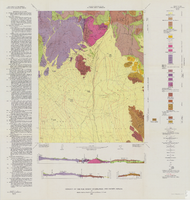
Soil map, Nevada, Moapa Valley sheet, 1923
Date
1923
Archival Collection
Description
'U.S. Department of Agriculture, Bureau of Chemistry and Soils; C.A. Browne, Acting Chief; Curtis F. Marbut, in charge, Soil Survey.' 'Macy H. Lapham, Inspector, District 5. Soils surveyed by F.O. Youngs, in charge, and E.J. Carpenter.' 'Field Operations, Bureau of Soils, 1923.' 'A, Hoen & Co. Lith. Baltimore, Md.' Shows township and range lines. Scale [1:63,360]. 1 in. = 1 mile (W 114°45´--W 114°18´/N 36°51´--N 36°24´). Library's copy has hand-written notes and has hand-drawn maps and notes on verso.
Image

Map of well locations, Las Vegas Valley, Nevada, 1975
Date
1976
Description
'Cartography by Marj Thielke.' 'Prepared in cooperation with the State of Nevada, Department of Conservation and Natural Resources, Division of Water Resources.' Relief shown by contours. Shows township and range lines. Originally published as Plate 1 in Water-level changes associated with ground-water development in Las Vegas Valley, Nevada, 1971-75 : fourth progress report--summary of data / by James R. Harrill, published in 1976 by the Department of Conservation and Natural Resources, Division of Water Resources, as volume 22 of Water resources-information series report. Scale [ca. 1:69,696. 1 in.=approx. 1.1 miles] (W 115°20´--W 115°00´/N 36°20´--N 36°00´).
Image
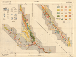
Geology of the Oak Spring Quadrangle, Nye County, Nevada, 1963
Date
1963
Description
58 x 46, on sheet 88 x 84 cm., fold. in envelope 30 x 24 cm. Relief shown by contours and spot heights. "Contour interval 20 feet." "Prepared in cooperation with the U.S. Atomic Energy Commission." Title on envelope: Geologic map of the Oak Spring Quadrangle, Nye County, Nevada. Includes 3 col. cross sections, text, and quadrangle location map. Original publisher: Interior, Geological Survey, Series: Geologic quadrangle map GQ, Scale: 1:24 000.
Image
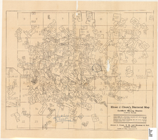
Map of the Goldfield Mining District, Goldfield, Nevada, 1907
Date
1907
Description
'Elmer J. Chute, E.M. and Olmstead and Rich, Goldfield, Nevada. Copyright 1907, by Elmer J. Chute, Goldfield, Nev.' Includes information on and prices for wall and pocket map with this title. Includes inset map. Includes township and range grid. Library's copy has Rochester GF. claim circled in blue ink , has a piece missing to the right of that claim, and has "Mohawk ledge, a lease by Davis & Shoemaker" written in blue ink at the center bottom of the map with a line in blue ink drawn to the Frances Mohawk claim.
Image