Search Results
New Mexico
Level of Description
File
Archival Collection
UNLV University Libraries Menu Collection
To request this item in person:
Collection Number: MS-00436
Collection Name: UNLV University Libraries Menu Collection
Box/Folder: N/A
Collection Name: UNLV University Libraries Menu Collection
Box/Folder: N/A
Archival Component
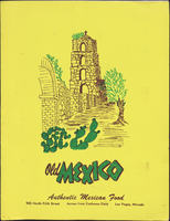

Old Mexico menu
Date
1950 (year approximate) to 1980 (year approximate)
Archival Collection
Description
Note: Front cover illustration has the initials "MF." in very small print. Menu is in Spanish and English with a "Spanish food dictionary" printed at the bottom Menu insert: Wine lists Restaurant: Old Mexico Location: 905 North 5th Street, Las Vegas, Nevada, United States
Text

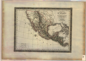
Map of California, territories of New Mexico, Arizona, Colorado, Nevada and Utah, circa 1863
Date
1861 to 1865
Description
40 x 62 cm. Relief shown by hachures and spot heights. Prime meridians: Greenwich and Washington. "Historical and statistical view of the United States, 1860"--Verso. Atlas page numbers at top: 58-59. Arizona became a territory in 1863, and Nevada became a state on October 31, 1864, so this map was either published in 1863 or in 1864 before the end of October. Original publisher: Johnson and Ward.
Image
1968 Summer Olympics in Mexico City, Mexico administrative files, 1968
Level of Description
File
Archival Collection
Gerald Schaffer Professional Papers
To request this item in person:
Collection Number: MS-01065
Collection Name: Gerald Schaffer Professional Papers
Box/Folder: Box 01
Collection Name: Gerald Schaffer Professional Papers
Box/Folder: Box 01
Archival Component
1968 Summer Olympics in Mexico City, Mexico: photographic prints, 1968
Level of Description
File
Archival Collection
Gerald Schaffer Professional Papers
To request this item in person:
Collection Number: MS-01065
Collection Name: Gerald Schaffer Professional Papers
Box/Folder: Box 01
Collection Name: Gerald Schaffer Professional Papers
Box/Folder: Box 01
Archival Component
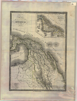
Map of Mexico and Central America, 1826
Date
1826
Description
'Par L. Vivien, Géographe, Gravée par Giraldon-Bovinet. 1826, Paris. Chez Ménard & Desenne, Rue Git-le-Coeur, No. 8.' Scale [ca. 1:15,840,000] (W 125°--W 75°/N 35°--N 05°). Relief shown by hachures. Hand colored. Atlas plate number in upper margin: no. 34. Ménard & Desenne
Image
Correspondence,, Mexico, 1984
Level of Description
File
Archival Collection
Desert Fishes Council Records
To request this item in person:
Collection Number: MS-00572
Collection Name: Desert Fishes Council Records
Box/Folder: Box 06
Collection Name: Desert Fishes Council Records
Box/Folder: Box 06
Archival Component
Marriage: Mexico, 2016
Level of Description
File
Archival Collection
Dennis McBride Collection on LGBTQ Las Vegas, Nevada
To request this item in person:
Collection Number: MS-00802
Collection Name: Dennis McBride Collection on LGBTQ Las Vegas, Nevada
Box/Folder: Box 26
Collection Name: Dennis McBride Collection on LGBTQ Las Vegas, Nevada
Box/Folder: Box 26
Archival Component
Map of Mexico and Central America, 1842
Date
1842
Description
'Dresseé par M. Lapie, Colonel d'Etat Major. Et M. Lapie fils Capitaine au même Corp. Paris, 1842. Chez P.C. Lehuby Libre. Rue de Seine No. 53.' Scale [ca. 1:9,504,000. 1 in. to approx. 15 miles]. Relief shown by hachures. Prime meridian: Paris. Hand colored. 'Atlas universel 44e'--Upper margin. Probably from P. Lapie and A.É. Lapie's Atlas universel de géographie ancienne et moderne. Inset map: Carte du Guatemala ou provinces-unies de L'Amérique Centrale. P.C. Lehuby
Image