Search Results
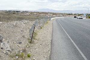
Undeveloped land along Pecos Ridge Parkway west of Eastern Avenue with custom homes above, looking west-southwest in Henderson, Nevada: digital photograph
Date
Archival Collection
Description
From the UNLV University Libraries Photographs of the Development of the Las Vegas Valley, Nevada (PH-00394). Part of the collection documents the entire 19 mile length of the north/south Eastern Avenue / Civic Center Drive alignment. This photograph was captured in the section of Eastern Avenue between Sunridge Heights Parkway and Grand Hills Drive.
Image
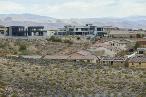
Custom and track homes with undeveloped land off Pecos Ridge Parkway west of Eastern Avenue with custom homes above, looking west-southwest in Henderson, Nevada: digital photograph
Date
Archival Collection
Description
From the UNLV University Libraries Photographs of the Development of the Las Vegas Valley, Nevada (PH-00394). Part of the collection documents the entire 19 mile length of the north/south Eastern Avenue / Civic Center Drive alignment. This photograph was captured in the section of Eastern Avenue between Sunridge Heights Parkway and Grand Hills Drive.
Image
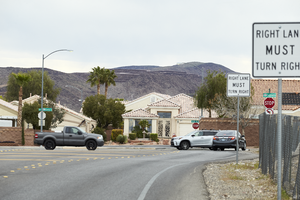
Cars pass in front of single family homes across Eastern Avenue as seen from Pecos Ridge Parkway, looking east-northeast in Henderson, Nevada: digital photograph
Date
Archival Collection
Description
From the UNLV University Libraries Photographs of the Development of the Las Vegas Valley, Nevada (PH-00394). Part of the collection documents the entire 19 mile length of the north/south Eastern Avenue / Civic Center Drive alignment. This photograph was captured in the section of Eastern Avenue between Sunridge Heights Parkway and Grand Hills Drive.
Image
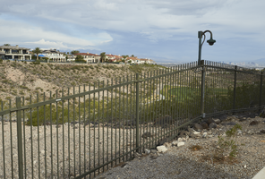
Fencing and a security camera for the Via Travoli custom homes development off Grand Hills Drive and Eastern Avenue, looking west-northwest in Henderson, Nevada: digital photograph
Date
Archival Collection
Description
From the UNLV University Libraries Photographs of the Development of the Las Vegas Valley, Nevada (PH-00394). Part of the collection documents the entire 19 mile length of the north/south Eastern Avenue / Civic Center Drive alignment. This photograph was captured in the section of Eastern Avenue between Sunridge Heights Parkway and Grand Hills Drive.
Image
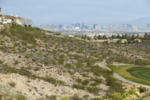
Custom homes along a ridge above the Rio Secco Golf Course with Las Vegas in distance as seen from Grand Hills Drive and Eastern Avenue, looking north-west in Henderson, Nevada: digital photograph
Date
Archival Collection
Description
From the UNLV University Libraries Photographs of the Development of the Las Vegas Valley, Nevada (PH-00394). Part of the collection documents the entire 19 mile length of the north/south Eastern Avenue / Civic Center Drive alignment. This photograph was captured in the section of Eastern Avenue between Sunridge Heights Parkway and Grand Hills Drive.
Image
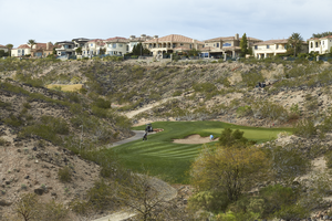
Custom homes along a ridge above the Rio Secco Golf Course with Las Vegas in distance as seen from Grand Hills Drive and Eastern Avenue, looking north-west in Henderson, Nevada: digital photograph
Date
Archival Collection
Description
From the UNLV University Libraries Photographs of the Development of the Las Vegas Valley, Nevada (PH-00394). Part of the collection documents the entire 19 mile length of the north/south Eastern Avenue / Civic Center Drive alignment. This photograph was captured in the section of Eastern Avenue between Sunridge Heights Parkway and Grand Hills Drive.
Image
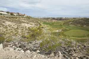
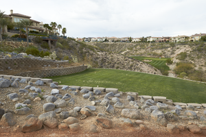
Custom homes along a ridge above the Rio Secco Golf Course as seen from Grand Hills Drive and Eastern Avenue, looking south in Henderson, Nevada: digital photograph
Date
Archival Collection
Description
From the UNLV University Libraries Photographs of the Development of the Las Vegas Valley, Nevada (PH-00394). Part of the collection documents the entire 19 mile length of the north/south Eastern Avenue / Civic Center Drive alignment. This photograph was captured in the section of Eastern Avenue between Sunridge Heights Parkway and Grand Hills Drive.
Image
Custom homes along ridges above the Rio Secco Golf Course as seen from Grand Hills Drive and Eastern Avenue, looking south in Henderson, Nevada: digital photograph
Date
Archival Collection
Description
From the UNLV University Libraries Photographs of the Development of the Las Vegas Valley, Nevada (PH-00394). Part of the collection documents the entire 19 mile length of the north/south Eastern Avenue / Civic Center Drive alignment. This photograph was captured in the section of Eastern Avenue between Sunridge Heights Parkway and Grand Hills Drive.
Image
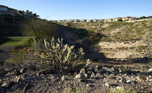
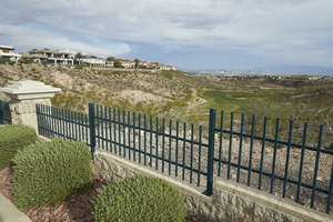
Cactus and desert landscaping on the Rio Secco Golf Course with custom homes along Grand Hills Drive near Eastern Avenue, looking south in Henderson, Nevada: digital photograph
Date
Archival Collection
Description
From the UNLV University Libraries Photographs of the Development of the Las Vegas Valley, Nevada (PH-00394). Part of the collection documents the entire 19 mile length of the north/south Eastern Avenue / Civic Center Drive alignment. This photograph was captured in the section of Eastern Avenue between Grand Hills and Sun City Anthem Drives.
Image