Search Results
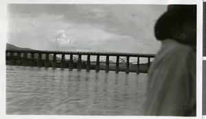
Damage done to bridge where four bents of this bridge being entirely washed out, 1938
Level of Description
File
Archival Collection
Union Pacific Railroad Photographs
To request this item in person:
Collection Number: PH-00043
Collection Name: Union Pacific Railroad Photographs
Box/Folder: Oversized Box 01
Collection Name: Union Pacific Railroad Photographs
Box/Folder: Oversized Box 01
Archival Component
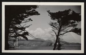
Photograph of the Golden Gate Bridge, San Francisco, California, circa mid 1900s
Date
1935 to 1959
Archival Collection
Description
An image of the Golden Gate Bridge as seen between the silhouettes of a pair of trees. The bridge spans across the Golden Gate Strait in San Francisco, California. Officially opened to the public in 1937, the 4,200 foot suspension bridge stood at a height of 746 ft (227 meters) upon completion.
Image
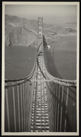
Photograph of the Golden Gate Bridge, San Francisco, California, circa mid 1900s
Date
1935 to 1959
Archival Collection
Description
An image of the Golden Gate Bridge, presumably under construction. The bridge spans across the Golden Gate Strait in San Francisco, California. Officially opened to the public in 1937, the 4,200 foot suspension bridge stood at a height of 746 ft (227 meters) upon completion.
Image
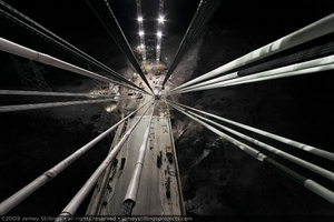
Photograph showing an aerial view of construction of the Mike O'Callaghan-Pat Tillman Memorial Bridge as seen from temporary pylons on the Arizona side of the bridge, July 1, 2009
Date
2009-07-01
Archival Collection
Description
Photographer's notes: "Night time from the top of the Arizona side temporary pylons looking down through the cable stays to the Arizona bridge deck. Notes: This is one of the few hand held night time photographs from the project. This was the only evening I was allowed on top of the temporary pylons to shoot." Site Name: Mike O'Callaghan-Pat Tillman Memorial Bridge
Image
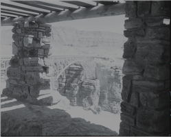
Film transparency of of the Navajo Bridge, Grand Canyon, Arizona, circa 1930s
Date
1930 to 1939
Archival Collection
Description
A view of the Navajo Bridge from inside an adjacent stone building, possibly the Old Cliff Dwellers Lodge (Blanche Russell Rock House), that was built circa 1920. Navajo Bridge crosses the Colorado River's Marble Canyon near Lee's Ferry in Arizona. It carries U.S. Route 89A. Spanning Marble Canyon, the bridge carries U.S. Route 89A northbound travelers to southern Utah and to the Arizona Strip, the otherwise inaccessible portion of Arizona north of the Colorado River, which includes the North Rim of Grand Canyon National Park. Prior to the construction of the first Navajo Bridge, the only river crossing from Arizona to Utah was at nearby Lee's Ferry, where the canyon walls are low and getting vehicles onto the water is relatively convenient. The ferry offered only unreliable service, however, as adverse weather and flooding regularly prevented its operation. Construction of the original Navajo Bridge began in 1927, and the bridge opened to traffic in 1929. The steel spandrel bridge design was constructed by the Kansas City Structural Steel Company. The bridge is 834 feet (254 m) in length, with a maximum height of 467 feet (142 m) from the canyon floor. Its roadway offers an 18-foot (5.5 m) surface width with a load capacity of 22.5 tons (although the posted legal weight limit was 40 tons). In 1990, however, it was decided that the traffic flow was too great for the original bridge, and that a new solution was needed. Deciding on a solution was difficult, due to the many local interests. Issues included preservation of sacred Navajo land, endangered plant species in Marble Canyon, and the possibility of construction pollution entering the river. A new steel arch bridge was commissioned by the Arizona Department of Transportation and the Federal Highway Administration, and was completed in September 1995, at a cost of approximately $15 million. The original Navajo Bridge is still open to pedestrian and equestrian use, and an interpretive center has been constructed nearby to showcase the historical nature of the bridge and early crossing of the Colorado River. Bungee jumpers are frequently seen using the span. The original bridge has been designated as a Historic Civil Engineering Landmark. The bridge was placed on the National Register of Historic Places on August 13, 1981.
Image
Photograph of the railroad bridge leading to the Hoover Dam gravel pit, circa 1930s
Date
1930 to 1939
Archival Collection
Description
Railroad bridge to gravel pit for dam. Six companies utilize the railroad bridge that crosses the Colorado river behind Hoover dam.
Image
Bridge 7.75; looking downstream, showing decking from Bridge 6.83 in foreground; decking from Bridge 7.75 in background, down-stream, 1938
Level of Description
File
Archival Collection
Union Pacific Railroad Photographs
To request this item in person:
Collection Number: PH-00043
Collection Name: Union Pacific Railroad Photographs
Box/Folder: Oversized Box 01
Collection Name: Union Pacific Railroad Photographs
Box/Folder: Oversized Box 01
Archival Component