Search Results

Map of California, with territories of Utah, Nevada, Colorado, New Mexico, and Arizona, 1864
Date
1864
Description
40 x 62 cm. Relief shown by hachures. Prime meridians: Greenwich and Washington. Page numbers at top: 58-59. "Entered according to act of Congress in the year 1864 by A. J. Johnson in the Clerk's Office of the District Court of the United States for the Southern District of New York." Original publisher: Johnson and Ward.
Image

Map showing location of the Las Vegas & Tonopah Railroad from Las Vegas to Bullfrog, Nevada, 1906
Date
1906
Archival Collection
Description
'Office of Chief Engineer' printed on map above date.
Image

Las Vegas Valley map, Clark County, Nevada, June 1958
Date
1958
Description
'Compiled 1954. First revision - June 1958.' 'Area extends 9 miles north, 11 miles south, and 3 miles east, 3 miles west city limits of Las Vegas.' Original publisher: Campbell Realty. Scale [ca. 1:60,000. 1 in. to approx. 5,000 ft.]. Cadastral map. Hand-drawn red line around some sections on map.
Image
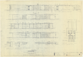
Architectural drawings of a residential home in Las Vegas, Nevada, November 2, 1962
Date
1963-11-02
Description
Exterior elevations and details for a residential home on Fifth Place in Las Vegas, Nevada. Sheet no. 4. "Drw. D.H."
Architecture Period: Mid-Century ModernistImage

Topographic map of the northeast quadrangle of the metropolitan Las Vegas, Nevada area, 1967
Date
1967
Description
Scale 1:24,000 ; polyconic proj. (W 115°730--W 115°0000/N 36°1500--N 36°730) ; 1 map : col. ; 58 x 47 cm ; 7.5 minute series (topographic) ; Relief shown by contours and spot heights ; Filing title: Las Vegas NE, Nev ; "AMS 2956 II NE--Series V896." ; Contour interval 20 feet ; "Topography by photogrammetric methods from aerial photographs taken 1965. Field checked 1967." ;Includes quadrangle location map ; Interior--Geological Survey
Image

Topographic map of the northeast quadrangle of the metropolitan Las Vegas, Nevada area, 1973
Date
1973
Description
Scale 1:24,000 ; polyconic proj. (W 115°730--W 115°0000/N 36°1500--N 36°730) ; 1 map : col. ; 58 x 47 cm ; 7.5 minute series (topographic) ; Relief shown by contours and spot heights ; "AMS 2956 II NE--Series V896." ; Contour interval 20 feet ; "Topography by photogrammetric methods from aerial photographs taken 1965. Field checked 1967." ; "Revisions shown in purple compiled from aerial photographs taken 1973. This information not field checked." ; Includes quadrangle location map ; Filing title: Las Vegas, NE, Nev ; Interior--Geological Survey
Image

Topographic map of the northwest quadrangle of the metropolitan Las Vegas, Nevada area, 1967
Date
1967
Description
Scale 1:24,000 ; polyconic proj. (W 115°1500--W 115°730/N 36°1500--N 36°730) ; 1 map : col. ; 58 x 47 cm ; 7.5 minute series (topographic) ; Relief shown by contours and spot heights ; Filing title: Las Vegas NW, Nev ; "AMS 2956 II NW--Series V896." ; Contour interval 10 feet ; "Topography by photogrammetric methods from aerial photographs taken 1965. Field checked 1967." ; Includes quadrangle location map ; Interior--Geological Survey
Image

Topographic map of the northwest quadrangle of the metropolitan Las Vegas, Nevada area, 1973
Date
1973
Description
Scale 1:24,000 ; polyconic proj. (W 115°1500--W 115°730/N 36°1500--N 36°730) ; 1 map : col. ; 58 x 47 cm ; 7.5 minute series (topographic) ; Relief shown by contours and spot heights ; Filing title: Las Vegas NM, Nev ; "AMS 2956 II NW--Series V896." ; Contour interval 10 feet ; "Topography by photogrammetric methods from aerial photographs taken 1965. Field checked 1967." ; "Revisions shown in purple compiled from aerial photographs taken 1973. This information not field checked." ; Includes quadrangle location map ; Interior--Geological Survey
Image

Topographic map of the southeast quadrangle of the metropolitan Las Vegas, Nevada area, 1984
Date
1984
Description
Scale 1:24,000 ; polyconic proj. (W 115°0730--W 115°0000/N 36°0730--N 36°0000) ; 1 map : col. ; 58 x 47 cm ; 7.5 minute series (topographic) ; Relief shown by contours and spot heights ; Filing title: Las Vegas SE, Nev ; "DMA 2956 II SE--Series V896." ; Contour interval 20 feet ; "Topography by photogrammetric methods from aerial photographs taken 1965. Field checked 1967." ; "Revisions shown in purple and woodland compiled from aerial photographs taken 1982 and other sources. This information not field checked. Map edited 1984." ; Includes quadrangle location map ; Interior--Geological Survey
Image

Topographic map of the southeast quadrangle of the metropolitan Las Vegas, Nevada area, 1973
Date
1973
Description
Scale 1:24,000 ; polyconic proj. (W 115°0730--W 115°0000/N 36°0730--N 36°0000) ; 1 map : col. ; 58 x 47 cm ; 7.5 minute series (topographic) ; Relief shown by contours and spot heights ; Filing title: Las Vegas SE, Nev ; "AMS 2956 II SE--Series V896." ; Contour interval 20 feet ; "Topography by photogrammetric methods from aerial photographs taken 1965. Field checked 1967." ; "Revisions shown in purple compiled from aerial photographs taken 1973. This information not field checked." ; Includes quadrangle location map ; Interior--Geological Survey
Image