Search Results
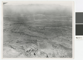
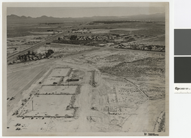
Aerial photograph of North Las Vegas looking west towards Mount Charleston, 1968
Date
Archival Collection
Description
Aerial view of North Las Vegas looking west with North Las Vegas Airport in the distance. The plane is directly over what is now I-15 and Cheyenne. In the foreground is a water tank where there are now many tanks.
Transcribed Notes: Handwritten on back: "Street Dept - Brooks, Cheyenne Area - 1968, looking west"
Image
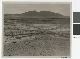
Photograph of Cheyenne Avenue looking east at Sunrise Mountain, June 5, 1973
Date
Archival Collection
Description
Cheyenne Avenue looking east at Sunrise Mountain.
Transcribed Notes: Handwritten on back: "Cheyenne looking east at sunrise. NLV - Streets & Roads - Photos" Stamped on back: "CNLV Engineering Dept."
Image
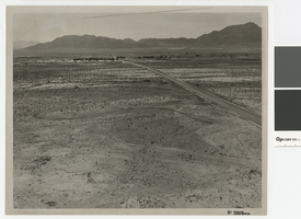
Aerial photograph over Cheyenne Avenue looking southeast, June 5, 1973
Date
Archival Collection
Description
Aerial view over Cheyenne Avenue looking southeast towards Frenchman Mountain
Transcribed Notes: Handwritten on back: "Over Cheyenne looking SE" Stamped on back: "CNLV Engineering Dept"
Image
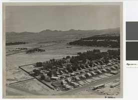
Aerial photograph of Las Vegas Boulevard and Nellis Boulevard, June 5, 1973
Date
Archival Collection
Description
Aerial view of Las Vegas Blvd. and Nellis Blvd looking north.
Transcribed Notes: Handwritten on back: "LV Blvd & Nellis Blvd looking north" Stamped on back: CNLV Engineering Dept"
Image
Aerial photograph of Las Vegas Blvd. and Cheyenne Ave., Las Vegas, June 5, 1973
Date
Archival Collection
Description
Aerial view of Las Vegas Blvd. and Cheyenne Avenue looking north.
Transcribed Notes: Transcribed from back of photo: "Building site of Safeway"
Image
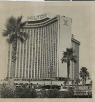
Photograph of the front exterior of the Las Vegas Hilton, circa 1971-1974
Date
Archival Collection
Description
Las Vegas Hilton before expansions made in 1975. The International Hotel was sold in 1970 and renamed the Las Vegas Hilton in 1971.
Site Name: International Hotel
Address: 3000 Paradise Road
Image

Transcript of interview with Mildred Breedlove by Steve Drappo, February 18, 1979
Date
Archival Collection
Description
Text
Transcript of interview with Peter Gratton by Clayee D. White, February 26, 2009
Date
Archival Collection
Description
Text
Transcript of interview with Dr. Lonnie D. Spight by Dr. David Emerson, May 8, 2007
Date
Archival Collection
Description
Text
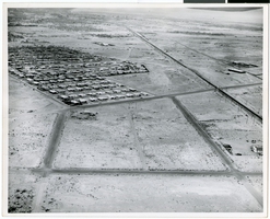
Aerial photograph of North Las Vegas, circa early 1970s
Date
Archival Collection
Description
Image