Search Results
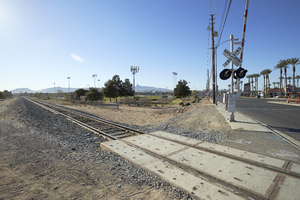
Railroad crossing Eastern Avenue north of Warm Springs Road, looking south-southeast in Las Vegas, Nevada: digital photograph
Date
Archival Collection
Description
From the UNLV University Libraries Photographs of the Development of the Las Vegas Valley, Nevada (PH-00394). Part of the collection documents the entire 19 mile length of the north/south Eastern Avenue / Civic Center Drive alignment. This photograph was captured in the section of Eastern Avenue between Sunset and Warm Springs Roads.
Image
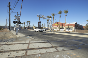
Railroad crossing Eastern Avenue north of Warm Springs Road, looking southwest in Las Vegas, Nevada: digital photograph
Date
Archival Collection
Description
From the UNLV University Libraries Photographs of the Development of the Las Vegas Valley, Nevada (PH-00394). Part of the collection documents the entire 19 mile length of the north/south Eastern Avenue / Civic Center Drive alignment. This photograph was captured in the section of Eastern Avenue between Sunset and Warm Springs Roads.
Image
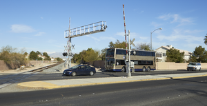
Railroad crossing Eastern Avenue north of Warm Springs Road, looking west in Las Vegas, Nevada: digital photograph
Date
Archival Collection
Description
From the UNLV University Libraries Photographs of the Development of the Las Vegas Valley, Nevada (PH-00394). Part of the collection documents the entire 19 mile length of the north/south Eastern Avenue / Civic Center Drive alignment. This photograph was captured in the section of Eastern Avenue between Sunset and Warm Springs Roads.
Image
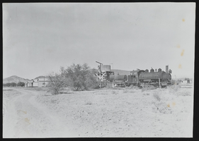
Tecopa Railroad, train and station: photograph
Date
Archival Collection
Description
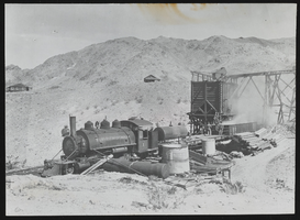
Tecopa Railroad #1 2-6-2T at BLW at Tecopa, California. (interchange with Tonopah & Tidewater). Stamp on the back of the photo reads: "Mallory Hope Ferrell P. O. Box 2837 Peachtree City, GA 30269."
Image
Photograph of desert, Tecopa (Calif.), 1907-1918
Date
Archival Collection
Description
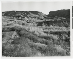
Desert landscape with hills and valleys; dirt in piles suggests this area was under construction. Inscription reads: "T&T grade at Tecopa end of famous Amargosa River Canyon."
Image
Photograph of the Tecopa Railroad Engine No. 1, Tecopa (Calif.), 1920
Date
Archival Collection
Description
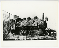
Train ran to Noonday and Gunsight Mines; short-lived mines and railroad. Myrick RR of Nevada Eastern & Calif. This photo may have been taken in Ca, as that's where it was incorporated.
Caption: Old Engine at Tecopa, Calif.
Image
Noonday Mine locomotive: photograph
Date
Archival Collection
Description
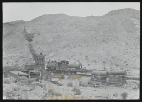
Tecopa Railroad (1910-1932) #1 2-6-2T BLW 1909 #34089. Noonday Mine, near Tecopa, Calif. Stamp on back of photo: "Mallory Hope Ferrell P. O. Box 2837 Peachtree City, GA 30269."
Image
Noonday Mine front angle, Tecopa Railroad: photograph
Date
Archival Collection
Description
Tecopa Railroad #1 2-6-2T. Noonday Mine, Tecopa, California. Stamp on the back of the photo reads: "Mallory Hope Ferrell P. O. Box 2837 Peachtree City, GA 30269."
Image
Art Rader Photograph Collection on Nevada Railroads
Identifier
Abstract
The Art Rader Photograph Collection on Nevada Railroads depicts railroads, mills, and depots in Nevada and Southern California from 1905 to approximately 1975. The photographs primarily depict the remnants of the Tonopah & Tidewater Railroad, the Pacific Coast Borax Company, and obsolete tracks, buildings, mills, and boxcars from the early-twentieth century. The photographs also depict depots and railroad intersections in Death Valley Junction, California and Crucere, California, and the photographs include the Union Pacific Railroad's tracks that were once part of the Salt Lake Railroad.
Archival Collection
Nye County, Nevada Photograph Collection
Identifier
Abstract
The Nye County, Nevada Photograph Collection contains photographs from Nye County, Nevada from 1880 to 1990. The collection includes a wide variety of photographs that document the activities, landmarks, geographical features, towns, ranches, and families of Nye County. The collection covers the areas of Amargosa Valley, Ash Meadows, Beatty, Duckwater, Gabbs, Goldfield, Kawich Mountains, Manhattan, Pahrump, Round Mountain, Rhyolite, Smoky Valley, Springdale, Tecopa, Tonopah, and Twin Springs. The activities documented include mining, prospecting, herding animals, schooling, ranching, building construction, railroad construction, and hunting and fishing.
Archival Collection