Search Results
Letter from Roy A. Wehe (San Francisco) to Edward C. Renwick (Los Angeles), November 23, 1951
Date
Archival Collection
Description
If the Union Pacific should divest itself of water production to the Las Vegas Land and Water Company, Wehe describes what the operation of the company should look like. Letter has several date stamps, including one from E. E. Bennett and one from the Union Pacific Railroad Law Department.
Text
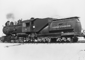
Negative: Tonopah and Tidewater Engine No. 8: photographic print
Date
Archival Collection
Description
From the Nye County, Nevada Photograph Collection (PH-00221) -- Series III. Beatty, Nevada -- Subseries III.G. Reidhead Family.
Image

Newspaper clipping, Where I stand, Las Vegas Sun, May 9, 1953
Date
Archival Collection
Description
Editorial from the Las Vegas Sun. Unlike a noble French merchant, who sacrificed greatly to give the people of Marseilles good water, the water company is trying to bleed all the money they can out of the situation before surrendering it to the water district. "80-11" written in red pencil. Date stamp from E.C.R.
Text
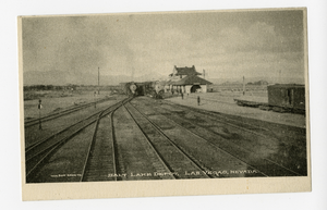
Photograph of the Salt Lake Depot railyard, Las Vegas (Nev.), 1900-1925
Archival Collection
Description
Image

Map of the United States of America, 1859
Date
Description
Image

Map of the United States of America, 1856
Date
Description
Image
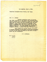
Letter from W. E. Smith to C. McLeod, March 27, 1913
Date
Archival Collection
Description
Text
Letter from Frank R. McNamee to C. C. Barry, June 6, 1923
Date
Archival Collection
Description
Text
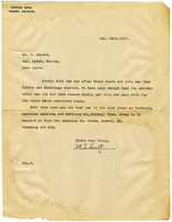
Letter from W. E. Smith to C. McLeod, October 14, 1913
Date
Archival Collection
Description
Text
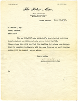
Letter from Clayton V. Smith to C. McLeod, June 5, 1913
Date
Archival Collection
Description
Text