Search Results
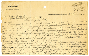
Letter from J. T. McWilliams to J. Ross Clark, November 9, 1902
Date
1902-11-09
Archival Collection
Description
Letter discusses the Clark's intention to purchase the Las Vegas Ranch for the railroad. McWilliams discusses the necessary measures to get a proper survey of the ranch.
Text
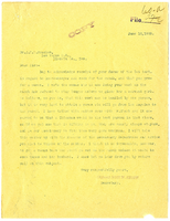
Letter from Ross W. Smith to J. K. W. Bracken, June 10, 1903
Date
1903-06-10
Archival Collection
Description
Letter discusses the need for a new house-keeper and cook at the Las Vegas Ranch. Smith addresses the problems with hiring a woman and suggests hiring a Chinese man.
Text
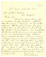
Letter from William McDermott to J. Ross Clark, March 31, 1903
Date
1903-03-31
Archival Collection
Description
Letter describes the behavior of Kiel Ranch operator, George Lattemore, in selling wine and whiskey to settlers in Las Vegas. McDermott complains that Lattemore is selling wine to his Indian employees.
Text
Letter from A. S. Halstead to C. P. Smith, September 23, 1922
Date
1922-09-23
Archival Collection
Description
Caption: Automobiles bought by company during strike
Text
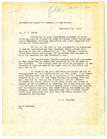
Letter from J. G. Scrugham to F. R. McNamee, March 9, 1923
Date
1923-03-09
Archival Collection
Description
Letter calls into question expenses for protecting railroad property.
Text
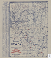
Sketch map of Nevada and the southeastern portion of California, 1906
Date
1906
Description
41 x 29 cm. Relief shown by hachures. Copyright held by George S. Clason. Includes index. "Compliments of Aston & Sears ... Goldfield, Nevada." Red stars probably indicate location of towns with either offices of or claims owned by Aston & Sears. Shows railroad routes. Ad for shares in the Diamond Bullfrog claim on verso. Original publisher: Clason Map Co..
Image
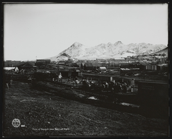
View of Tonopah from Railroad Depot: photograph
Date
1905
Archival Collection
Description
View of Tonopah from the Railroad Depot. Part of the Tonopah R.R. Yard (3) showing freight which has spilled over from depot platform. (note SPC cars 420, 712; Tonopah RR 4-wheel caboose #13) 1905. (photo: State Archives, Museums and Historical Dept.). Stamp on front of photo: "J. E. Stimson, Artist, Cheyenne, WYO. 892" Stamp on back of photo: "Mallory Hope Ferrell P. O. Box 2837 Peachtree City, GA 30269." Stamp on back of photo: "Publication of this photo must give credit line to the Wyoming State Archives, Museums, and Historical Department."
Image
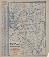
Sketch map of Nevada and the southeastern portion of California, 1906
Date
1906
Description
42 x 30 cm., fold. to 23 x 11 cm. Relief shown by hachures. Copyright: George S. Clason. "Compliments of D. Mackinzie & Company Incorporated, Mine Operators and Commission Brokers, Goldfield, Nevada." Company's locations in Goldfield and in Greenwater, California, are marked with red circles on the map. Includes index. Shows railroad routes. Original publisher: Clason Map Co..
Image
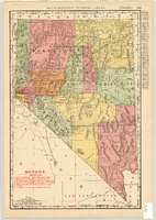
Map showing railroads in Nevada, 1904
Date
1904
Description
Relief shown by hachures. Added title: Rand McNally's new business map of Nevada. Shows range and township grid. Shows railroads. Color used to show boundaries of counties. Includes index to cities. On verso: Indexes to counties, lakes, mountains, rivers, towns, etc. Published by Rand McNally & Co. Scale [ca. 1:1,710,720]. 1 in. equals 27 miles (W 120°--W 114°/N 42°--N 35°). Originally published as pages 263 and 264 of Rand-McNally indexed atlas.
Text

Letter from Leo McNamee to Fred E. Pettit, Jr., July 29, 1922
Date
1922-07-29
Description
Letter reports how many and where copies of injunction against railroad strikers were posted. Asks for extra deputies.
Text