Search Results

Photograph of Belle Butler and Daisy Rendall at a mine in Tonopah, Nevada, circa 1901
Date
1900 to 1902
Archival Collection
Description
Belle Butler (wife of Jim Butler, lower left), and Daisy Rendall (later married to Nevada Governor Tasker Oddie), pose outside of adits at a mine near Tonopah, Nevada where Jim Butler first discovered gold.
Image
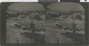
Photograph of mining views at night, Goldfield, Nevada, circa 1903
Date
1900 to 1930
Archival Collection
Description
Stereoview of Goldfield, Nevada taken by Olaf P. Larson. The images are mining views taken at night.
Image

Photograph of electrical line installation near mine, Candalaria,
Date
1900 to 1930
Archival Collection
Description
Black and white photograph of electrical lines being installed near a mine/mill.
Image

Photograph of electrical line installation near mine, Candalaria,
Date
1900 to 1930
Archival Collection
Description
Black and white photograph of electrical lines being installed near a mine/mill.
Image

Photograph of electrical line installation near mine, Candalaria,
Date
1900 to 1930
Archival Collection
Description
Black and white photograph of electrical lines being installed near a mine/mill.
Image

Photograph of electrical line installation near mine, Candalaria,
Date
1900 to 1930
Archival Collection
Description
Black and white photograph of electrical lines being installed near a mine/mill.
Image

Photograph of electrical line installation near mine, Candalaria,
Date
1900 to 1930
Archival Collection
Description
Black and white photograph of electrical lines being installed near a mine/mill.
Image
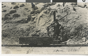
Photograph of Bluestone mine, Nevada, 1916
Date
1916
Archival Collection
Description
Black and white photograph of Bluestone mine taken by Steve.
Image

Postcard of the Consolidated Mines Co. New Mill, Goldfield, Nevada, 1908
Date
1908
Archival Collection
Description
A picture postcard of the Consolidated Mines Company, New Mill. An address is written on the back side.
Image
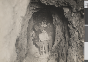
Photograph of four miners inside a mine shaft, probably in Nevada, circa 1900s
Date
1900 to 1909
Archival Collection
Description
Four unidentified miners with hand tools inside a mine shaft, probably in Nevada.
Image