Search Results
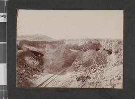
Photograph of Belle Butler and Daisy Rendall at a mine in Tonopah, Nevada, circa 1901
Date
1900 to 1902
Archival Collection
Description
Belle Butler (wife of Jim Butler, lower left), and Daisy Rendall (later married to Nevada Governor Tasker Oddie), pose outside of adits at a mine near Tonopah, Nevada where Jim Butler first discovered gold.
Image
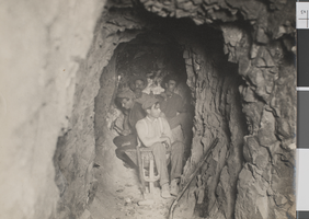
Photograph of four miners inside a mine shaft, probably in Nevada, circa 1900s
Date
1900 to 1909
Archival Collection
Description
Four unidentified miners with hand tools inside a mine shaft, probably in Nevada.
Image
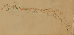
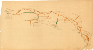
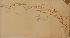
Map of the second level of the Red Top Mine, Goldfield, Nevada, circa 1902-1908
Date
1902 to 1908
Description
'Red Top 2nd level, 575780.' Hand-drawn, hand-colored and annotated map showing the second level of the Red Top Mine.
Image
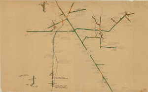
Map of the 380 foot level of the Combination Mine, Goldfield, Nevada, circa 1902-1908
Date
1902 to 1908
Description
'380 ft. level.' Hand-drawn, hand-colored and annotated map showing the 380 foot level of the Combination Mine.
Image
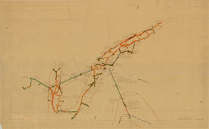
Map of the third level of the Red Top Mine, Goldfield, Nevada, circa 1902-1908
Date
1902 to 1908
Description
'Red Top 3rd level, 5659.90.' Hand-drawn, hand-colored and annotated map showing the third level of the Red Top Mine.
Image

Map of the 328 foot level of the Combination Mine, Goldfield, Nevada, circa 1902-1908
Date
1902 to 1908
Description
Hand-drawn, hand-colored and annotated map showing the 328 foot level of the Combination Mine.
Image
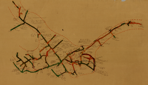
Map of the 130 foot level of the Combination Mine, Goldfield, Nevada, circa 1902-1908
Date
1902 to 1908
Description
'130 ft. level. Combination Mine.' 'Scale 1 in.=40 ft.' Hand-drawn, hand-colored and annotated map showing the 130 foot level of the Combination Mine.
Image
Map of the 330 foot level of the Combination Mine, Goldfield, Nevada, circa 1902-1908
Date
1902 to 1908
Description
Hand-drawn, hand-colored and annotated map showing the 330 foot level of the Combination Mine.
Image
Map of the 380 foot level of the Locke Mine, Goldfield, Nevada, circa 1902-1908
Date
1902 to 1908
Description
'380 ft. level.' Hand-drawn, hand-colored and annotated map showing the 380 foot level of the Locke Mine.
Image
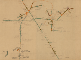
Map of the fourth level of the Red Top Mine, Goldfield, Nevada, circa 1902-1908
Date
1902 to 1908
Description
'Red Top, 4th level. 5586.90.' Hand-drawn, hand-colored and annotated map showing the fourth level of the Rep Top Mine.
Image