Search Results
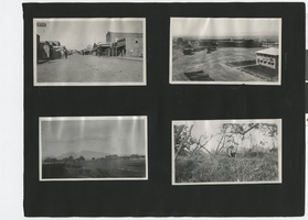
Photograph album 3, Ferron-Bracken Collection, circa 1905-1935, page 40
Date
1905 to 1935
Description
Photograph in upper left corner shows businesses on Fremont Street in Las Vegas, circa 1920s. Visible are part of the Majestic Theater, the Oasis Garden restaurant, Beckley's shoe store, the Overland Hotel, Dobson Bros. Grocers, The People's Store and the Union Pacific railroad station. Photograph in upper right corner shows the Union Pacific Railroad railyards in Las Vegas, circa 1910s-1920s.
Image
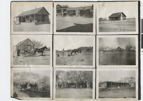
Photograph album 4, Ferron-Bracken Collection, circa 1905-1935, page 56
Date
1905 to 1935
Description
Two photographs on this page show the exteriors of the Arizona Hotel, the Midway Garage and the Desert Inn, in an unidentified downtown district.
Image

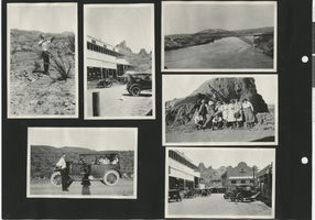
Photograph of street and businesses, Elko, Nevada, circa early 1900s
Date
1900 to 1920
Archival Collection
Description
Saloons, a harware store, and other businesses line a street in Elko Nevada. Across the street are railroad tracks and a donkey pulling a cart.
Image
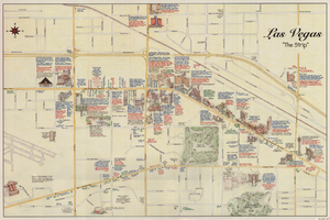
Maps of the Las Vegas Strip, downtown and metropolitan Las Vegas area, the Grand Canyon and southern Nevada, circa 1997
Date
1995 to 1999
Description
'Detail maps for downtown, neighborhoods, out of town, Grand Canyon' -- front panel. Maps on verso: Downtown -- Out of town and short adventures -- Greater Las Vegas -- Grand Canyon, South Rim Village. Major buildings and points of interest on the Las Vegas Strip shown pictorially. Includes text and notes. Originally published by MapEasy, Inc. Scale [ca. 1:10,560. 1 inch to approximately 1/6 mile].
Text

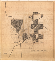
Map of downtown Las Vegas, Nevada, circa 1952-1955
Date
1952 to 1955
Description
Title in upper left and right margins: Las Vegas, Nevada. Identifies business tenants in the downtown area and includes property valuations, measurements, addresses, etc. Cadastral map. Oriented with north to the lower right.Text, illustrations, aerial photos, and ancillary map of the Las Vegas Strip on verso. Cataloger has determined date of map to be between 1952 and 1955 because the Sahara and the Sands Casinos are shown on the verso of the map, and they both opened in 1952, but the Riviera and the Dunes opened in 1955, and they are not shown on the map. Also, the Hotel Last Frontier is shown on the verso of the map, and its name was changed to New Frontier in 1955. Note: Many of the property names and addresses are erroneous when compared to Las Vegas business directories from the same period.
Image