Search Results
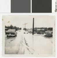
Photograph of flooding in Vegas Heights, Nevada, 1964
Date
Archival Collection
Description
Flooding at Balzar and Lasalle in Vegas Heights. Flooding due to lack of sewers and drainage. There is some residue on photo.
Image
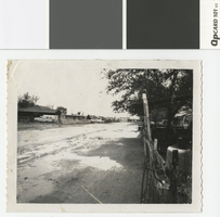
Photograph of flooded street in Vegas Heights, Nevada, 1964
Date
Archival Collection
Description
Flooding at Hassell and Highland in Vegas Heights after a rain storm. There is some residue on photo.
Transcribed Notes: Notes on attached sheet: Vegas Hts., 1964 - Hassell & Highland. Streets flooded during severe rain - no sewers or drainage.
Image
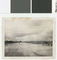
Photograph of flooding on road in Vegas Heights, Nevada, 1964
Date
Archival Collection
Description
Flooding at Revere and Hart Streets in the newly annexed Vegas Heights. There is residue on top border of photo.
Transcribed Notes: Notes on attached sheet: Vegas Heights (1964) - Revere & Hart Streets. Newly annexed part of Las Vegas - no sewers or proper drainage.
Image
Photograph of flooding along College Avenue, North Las Vegas, 1962
Date
Archival Collection
Description
Flooding along College Avenue, now Lake Mead, in North Las Vegas. From left to right, signs read: North Las Vegas City Limits - Please Observe Traffic Lanes; Retain Frank McNamee - Supreme Court Justice; Street signs: N Pecos St, E College Ave
Transcribed Notes: Stamped on back: Elton M. Garrett Collection; Valley Times - News
Image
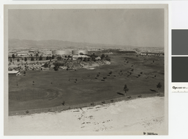
Photograph of North Las Vegas golf course, northwest direction, circa 1965
Date
Archival Collection
Description
North Las Vegas golf course with Parks and Recreation Building and city water tanks.
Transcribed Notes: Notes from photo sleeve: "North Las Vegas Golf Course (Par 3) with Parks and Recreation Building and city water storage tanks"; Notes on back: "NLV Par 3 Golf Course with P & R Bldg. and city water storage tanks."
Image
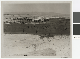
Photograph of North Las Vegas golf course, westward direction, circa 1965
Date
Archival Collection
Description
North Las Vegas golf course with Parks and Recreation Building and city water tanks.
Transcribed Notes: Notes from photo sleeve: "North Las Vegas Golf Course (Par 3) with Parks and Recreation Building and city water storage tanks"; Notes on back: "NLV Par 3 Golf Course with P & R Bldg. and city water storage tanks."
Image
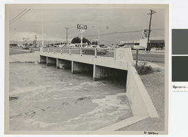
Photograph of water running high in flood channel and North Las Vegas Boulevard flood channel
Date
Archival Collection
Description
Flood channel with water running high under North Las Vegas Boulevard. Signs on front for 91 and 93 freeways
Transcribed Notes: Notes from photo sleeve: "Las Vegas Boulevard North and North Las Vegas flood channel, ca. 1970s." Notes on back: "Las Vegas Blvd North and NLV flood channel."
Image
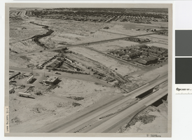
Aerial photograph of North Las Vegas flood control channel under I-15 and Civic Center Drive, June 5, 1973
Date
Archival Collection
Description
Flood control channel crossing I-15 and Civic Center Drive, Bullock's Feed and Tack store nearby.
Transcribed Notes: Notes from photo sleeve: "Aerial photo: Looking southeast. North Las Vegas flood control channel crosses I-15 and Civic Center Drive with Bulloch's Feed and Tack store next to channel. June 5, 1973." Stamped on back: "CNLV Engineering Dept." Notes on back: "Looking SE NLV Flood Control channel crosses I-15 and Civic Center Drive with Bullocks Feed and Tack store next to channel"
Image

Aerial photograph of Las Vegas Wash looking northwest, June 5, 1973
Date
Archival Collection
Description
Aerial view of Las Vegas Wash at Lake Mead Blvd. and Pecos Street in North Las Vegas.
Transcribed Notes: Stamped & written on back: CNLV Engineering Dept. - Date Jun 5 1973; Project - Land use Vegas Wash - SE; Lake Mead & Pecos Flood Control in county
Image
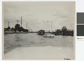
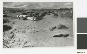
Photograph of flooding on Carey Avenue in North Las Vegas, 1970s
Date
Archival Collection
Description
Flooding on Carey Avenue, North Las Vegas.
Transcribed Notes: Notes on back: "Carey Ave Flooding"
Image