Search Results
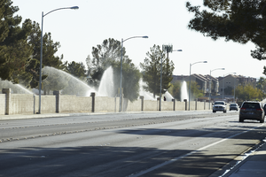
Sprinklers water the grass behind the brick walls of Palm Eastern Mortuary and Cemetery on Robindale Road off Eastern Avenue, looking east in Las Vegas, Nevada: digital photograph
Date
Archival Collection
Description
From the UNLV University Libraries Photographs of the Development of the Las Vegas Valley, Nevada (PH-00394). Part of the collection documents the entire 19 mile length of the north/south Eastern Avenue / Civic Center Drive alignment. This photograph was captured in the section of Eastern Avenue between Warm Springs Road and Windmill Parkway.
Image
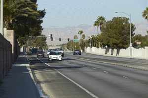
Traffic flows on Robindale Road off Eastern Avenue, looking west-southwest in Henderson, Nevada: digital photograph
Date
Archival Collection
Description
From the UNLV University Libraries Photographs of the Development of the Las Vegas Valley, Nevada (PH-00394). Part of the collection documents the entire 19 mile length of the north/south Eastern Avenue / Civic Center Drive alignment. This photograph was captured in the section of Eastern Avenue between Warm Springs Road and Windmill Parkway.
Image
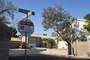
Signage designating private property on Terracotta Place at Robindale Road off Eastern Avenue, looking south-southwest in Henderson, Nevada: digital photograph
Date
Archival Collection
Description
From the UNLV University Libraries Photographs of the Development of the Las Vegas Valley, Nevada (PH-00394). Part of the collection documents the entire 19 mile length of the north/south Eastern Avenue / Civic Center Drive alignment. This photograph was captured in the section of Eastern Avenue between Warm Springs Road and Windmill Parkway.
Image

Power transmission lines turn westward along Eastern Avenue as seen from Robindale Road, looking north-northwest in Las Vegas, Nevada: digital photograph
Date
Archival Collection
Description
From the UNLV University Libraries Photographs of the Development of the Las Vegas Valley, Nevada (PH-00394). Part of the collection documents the entire 19 mile length of the north/south Eastern Avenue / Civic Center Drive alignment. This photograph was captured in the section of Eastern Avenue between Warm Springs Road and Windmill Parkway.
Image
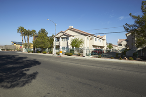
Single family homes flank the entrance to the Villa Sedona development across from the Palm Eastern Mortuary and Cemetery on Eastern Avenue, looking west-southwest in Las Vegas, Nevada: digital photograph
Date
Archival Collection
Description
From the UNLV University Libraries Photographs of the Development of the Las Vegas Valley, Nevada (PH-00394). Part of the collection documents the entire 19 mile length of the north/south Eastern Avenue / Civic Center Drive alignment. This photograph was captured in the section of Eastern Avenue between Warm Springs Road and Windmill Parkway.
Image
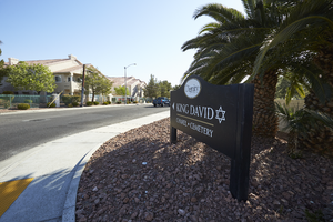
A sign touting the King David Chapel and Cemetery sits on Eastern Avenue with multi-family housing, looking northeast in Las Vegas, Nevada: digital photograph
Date
Archival Collection
Description
From the UNLV University Libraries Photographs of the Development of the Las Vegas Valley, Nevada (PH-00394). Part of the collection documents the entire 19 mile length of the north/south Eastern Avenue / Civic Center Drive alignment. This photograph was captured in the section of Eastern Avenue between Warm Springs Road and Windmill Parkway.
Image
Multi-family housing on Eldorado Lane, looking west-northwest in Las Vegas, Nevada: digital photograph
Date
Archival Collection
Description
From the UNLV University Libraries Photographs of the Development of the Las Vegas Valley, Nevada (PH-00394). Part of the collection documents the entire 19 mile length of the north/south Eastern Avenue / Civic Center Drive alignment. This photograph was captured in the section of Eastern Avenue between Warm Springs Road and Windmill Parkway.
Image
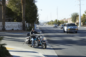
A motorcyclist turns onto Eastern Avenue from the Condominiums at Southpark development, looking south in Las Vegas, Nevada: digital photograph
Date
Archival Collection
Description
From the UNLV University Libraries Photographs of the Development of the Las Vegas Valley, Nevada (PH-00394). Part of the collection documents the entire 19 mile length of the north/south Eastern Avenue / Civic Center Drive alignment. This photograph was captured in the section of Eastern Avenue between Warm Springs Road and Windmill Parkway.
Image
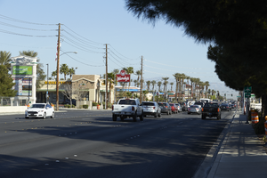
Traffic flows along Eastern Avenue near Warm Springs Road, looking north-northwest in Las Vegas, Nevada: digital photograph
Date
Archival Collection
Description
From the UNLV University Libraries Photographs of the Development of the Las Vegas Valley, Nevada (PH-00394). Part of the collection documents the entire 19 mile length of the north/south Eastern Avenue / Civic Center Drive alignment. This photograph was captured in the section of Eastern Avenue between Warm Springs Road and Windmill Parkway.
Image

A flood channel separates commercial and residential housing along Eastern Avenue, looking west in Las Vegas, Nevada: digital photograph
Date
Archival Collection
Description
From the UNLV University Libraries Photographs of the Development of the Las Vegas Valley, Nevada (PH-00394). Part of the collection documents the entire 19 mile length of the north/south Eastern Avenue / Civic Center Drive alignment. This photograph was captured in the section of Eastern Avenue between Warm Springs Road and Windmill Parkway.
Image