Search Results
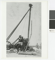
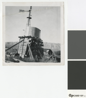
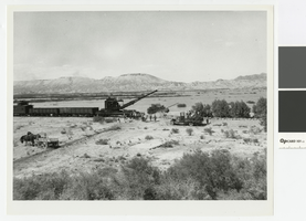
Photograph of a drill rig putting down the hole for the first well in the Las Vegas Heights District, circa 1907
Date
Archival Collection
Description
Drilling in the Las Vegas Heights District with Mr. Booth and Mr. Madison performing the work.
Transcribed Notes: Transcribed from front of photo: "1st well. Vegas Hts. About 1907. Booth & Madison, Drillers."; Transcribed from photo sleeve: "A drill rig which put down the hole for the first well in the Las Vegas Heights District in Las Vegas in 1907. The crew were Booth and Madison."
Image
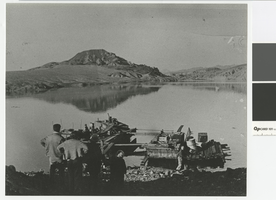
Photograph of Murl Emery work dock with Lake Mead rising in the background, 1935
Date
Archival Collection
Description
Murl Emery work dock, 1935, with Lake Mead rising
Transcribed Notes: Transcribed from back of photo: "Murl Emery work dock 1935 - Lake Rising"
Image
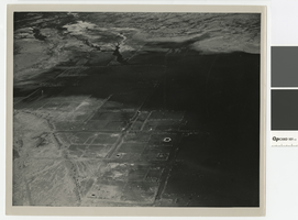
Aerial photograph of Saint Thomas, Nevada, being covered by Lake Mead, June 1938
Date
Archival Collection
Description
Aerial view of St. Thomas, Nevada, being covered by Lake Mead. Stamped on back of photo: Photograph by Bureau of Reclamation, Boulder Canyon Project, Boulder City, Nevada
Image
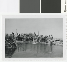
Photograph of a group of men releasing live rainbow trout into a pond, late 1950s
Date
Archival Collection
Description
Rainbow trout being released into a pond
Transcribed Notes: Transcribed from back of photo: "Dad & [Harold] unloading trout"
Image
Photograph of water tank in the Nevada desert, pre-1950
Date
Archival Collection
Description
Water tank in the desert. Sign on windmill reads: Fairbanks-Morse Steel Eclipse.
Image
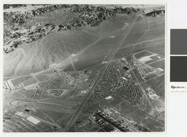
Aerial photograph of Downtown Henderson looking south towards Railroad Pass, circa 1963
Date
Archival Collection
Description
Aerial view of Henderson looking south towards Railroad Pass
Transcribed Notes: Transcribed from photo sleeve: "Aerial view of Downtown Henderson, NV"
Image
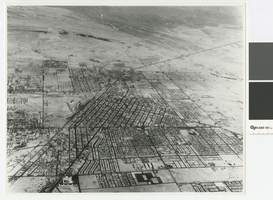
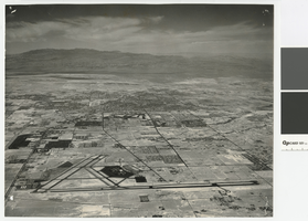
Aerial photograph of Las Vegas looking north, circa 1963
Date
Archival Collection
Description
Aerial view of Las Vegas looking north
Transcribed Notes: Transcribed from photo sleeve: "Aerial view of Las Vegas"
Image
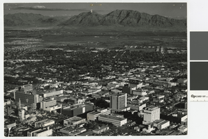
Aerial photograph of downtown Las Vegas looking east toward Frenchman Mountain, post-1953
Date
Archival Collection
Description
Aerial view of downtown Las Vegas looking east toward Frenchman Mountains. The following buildings are visible in the photograph: Lucky Casino, Horseshoe Casino, Fremont Hotel and Casino, Four Queens Casino, Golden Nugget, El Cortez Hotel, First National Bank, Bank of Nevada.
Transcribed Notes: Transcribed from photo sleeve: "Aerial view of Downtown Las Vegas"
Image
Aerial photograph of Las Vegas looking north, circa 1974
Date
Archival Collection
Description
Aerial view of Las Vegas looking north. The Strip, Paradise Road, and UNLV are visible in the photograph.
Transcribed Notes: Transcribed from photo sleeve: "Aerial view landing strip, Las Vegas Airport, 3-16-70"
Image
Photograph of Union Pacific Railroad crews removing tracks at the St. Thomas line, 1938
Date
Archival Collection
Description
Union Pacific Railroad crews taking up the St. Thomas line in advance of Lake Mead.
Transcribed Notes: Transcribed from photo sleeve: "Taking up track, advancing waters of Lake Mead in background"
Image