Search Results

Transcript of interview with John F. Cahlan by Radmila Radovich, February 27, 1980
Date
1980-02-27
Archival Collection
Description
John Cahlan (1902-1988) is interviewed by Radmila Radovich about the beginning of Las Vegas, including the role of the Union Pacific Railroad and its need for water. Cahlan discusses the changes in Las Vegas over time, including the evolution of the Western Air Express station to Nellis Air Force Base, as well as his concerns for the future of Las Vegas.
Text
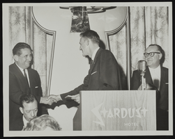
Dick Ronzone, standing left, shaking hands at an event at the Stardust Hotel: photographic print
Date
1962
Archival Collection
Description
Dick Ronzone (left, standing) and others at an event at the Stardust Hotel in 1962.
Image
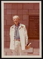
Portrait of Harvey Luce at the Harvey E. Luce Reservoir: photographic print
Date
1976
Archival Collection
Description
Harvey Luce pictured during the groundbreaking ceremonies for the Harvey Luce Reservoir (?) (1976).
Image

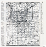
Map of metropolitan Las Vegas, Nevada area, circa 1957
Date
1955 to 1960
Description
Compiled and drawn by California State Automobile Association.--Panel ; "California State Automobile Association. Nevada Division." ; Includes indexes ; Includes inset maps of Nellis Air Force Base and area bounded on the north by Cheyenne Ave. and by Charleston Blvd. on the south. Signature of Elton M. Garrett of back of map. California State Automobile Association.
Text

Plat map of El Rancho Village, Clark County, Nevada, July 28, 1942
Date
1942-07-28
Description
Map of housing subdivision outside the Las Vegas city limits. 'Approved this 28 day of July1942, by the City Planning Commission of the City of Las Vegas, County of Clark, Nevada. Approved this 28 day of July 1942, by the County Planning Commission of the County of Clark, State of Nevada.' Blueline print. Oriented with north to the upper right. Embossed with Engineering Certificate seal of Frank D. Rathburn, which states. 'Survey completed August 4, 1942.' 'Book II, page 53' hand printed in lower right corner. Signed by Clark County, Nevada Notary Public and other coumty officials and officials of El Rancho Village. Published by Office of F.D. Rathbun. Scale [ca. 1:600]. 1 inch to 50 feet
Text
Map of greater Las Vegas area, 1964-1965
Date
1964 to 1965
Description
Scale [ca. 1:51,322] ; 1 map ; 55 x 43 cm ; Panel title: Front Boy's official 1964-1965 edition street map : detailed guide of North Las Vegas, Las Vegas, Paradise Valley and vicinity ; Originally folded to: 29 x 12 cm ; Relief shown by spot heights ; Includes notes and quotations ; Includes indexes; Alt Title: Front Boy's official 1964-1965 edition street map : detailed guide of North Las Vegas, Las Vegas, Paradise Valley and vicinity ; Alt Title: Official 1964-1965 edition street map Front Boy Service Co..
Text
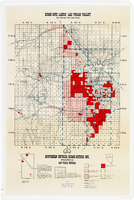
Map showing home-site lands in the Las Vegas Valley, 1955
Date
1955
Description
Scale [1:84,269. 1 in. to 1 1/3 miles] ; 1 map : col. ; 57 x 50 cm. on sheet 89 x 59 cm ; Cadastral map ; Gives definition of township, section and acre ; Relief shown by form lines and spot heights ; Shows private land, land classified for small tracts, leased land, vacant Federal land, section numbers, number of acres in each homesite and purchase price of tract ; "From your Congressman Cliff Young."--stamped on map ; Southern Nevada Home-Siters
Image
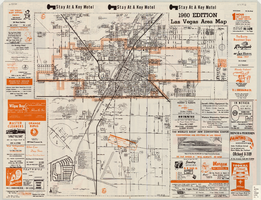
Las Vegas area map, 1960
Date
1960
Description
1960 ed. Scale [ca. 1:47,520. 1 in. equals approx. 0.75 miles.] 1 map : col. ; 41 x 43 cm., folded to 22 x 10 cm. Panel title: Welcome map : greater Las Vegas area and scenic routes to and from there. "1960-61 edition."--Panel. Irregularly-shaped map. Includes list of Las Vegas schools, inset maps of East Las Vegas (Whitney) and Wherry housing area on Nellis Air Force Base and advertisements for Las Vegas businesses. Index, mileages from cities in the United States to Las Vegas and sightseeing information on verso. Library's copy 1 has some art work and some lettering in orange and has "Las Vegas Nevada Chamber of Commerce" stamped in purple on panel. Library's copy 2 has some art work and some lettering in purple and has "Pioneer Title Insurance Co. of Nevada" stamped in black on panel. Nevada State Motel Association?
Text
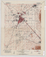
Topographic map of the Las Vegas Valley Area, 1952
Date
1952
Description
Scale 1:62,500 ; polyconic proj ; 1 map : col. ; 45 x 36 cm.; Relief shown by contours and spot heights. Contour interval 20 ft. ; Includes quadrangle location map ; Nevada 15 minute series (topographic) ; Fifteen minute series (topographic) Nevada ; Geological Survey
Image

Map of Las Vegas Valley, Clark County, Nevada, 1954
Date
1954
Description
Scale [ca. 1:63,360. 1 in. to approx. 5,280 ft.].Cadastral map. 'Compiled for C.D. Baker, Reg. Civil Engineer Nevada No. 6 and Licensed Real Estate Broker by Tyson Engineering Co., Las Vegas, Nevada.' 'Copyright 1954 Tyson Engineering Co., Las Vegas, Nevada. Drawn by E.M. Ballinger' Tyson Engineering Company
Image