Search Results
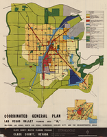
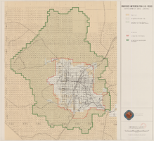
Map showing coordinated general plan for Las Vegas Valley, Planning Area A5, circa 1965-1968
Date
1963 to 1970
Description
Subtitle:'Including Las Vegas, North Las Vegas, Henderson, Boulder City, and the unincorporated areas.' 'Clark County Master Planning Program, Clark County, Nevada.' 'Eisner-Stewart and Associates, Planning Consultants, South Pasadena, California.' Includes inset of Boulder City. Text on verso about the general plan for the Las Vegas Valley, Clark County Master Planning Program Area. Published between 1965 and 1968? Scale [ca. 1:84,269. 1 inch to approximatley 1 1/3 miles].
Text

Map showing proposed metropolitan Las Vegas development area, June 24, 1997
Date
1997-06-24
Description
'Data sources: Advanced Planning Division, Clark County, Nevada.' 'Comprehensive Planning, Advanced Planning Division.' 'June 24, 1997.' Shows federal land, metropolitan Las Vegas development area, Las Vegas urban growth boundary and section lines. Scale [ca. 1:154,056. 1 inch to approx. 12,838 feet].
Image
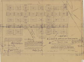
Map of Clark's Las Vegas Townsite, May 8, 1905
Date
1905-05-08
Archival Collection
Description
'Book 1, Page 37.' 'Dated: May 8th, 1905.' Subtitle: 'Being a sub-division of parts of the W.1/2 and the W.1/2 of the N.E.1/4 of Section 34 and the S.1/2 of the S.W.1/4 of Section 27 T.20 S.R. 61 E, Mount Diablo Base and Meridian, Lincoln County, Nevada. A Plat map. Blueline print. Scale [ca. 1:2,400]. 1 in. to 200 feet.
Text

Map of Las Vegas and vicinity, Clark County, Nevada, November 1952
Date
1952-11
Description
'Copyright 1950. 3rd issue, November 1952.'
Image

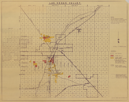
Las Vegas Valley map, Clark County, Nevada, June 1958
Date
1958
Description
'Compiled 1954. First revision - June 1958.' 'Area extends 9 miles north, 11 miles south, and 3 miles east, 3 miles west city limits of Las Vegas.' Original publisher: Campbell Realty. Scale [ca. 1:60,000. 1 in. to approx. 5,000 ft.]. Cadastral map. Hand-drawn red line around some sections on map.
Image
Map of Las Vegas Valley, 1968
Date
1968
Description
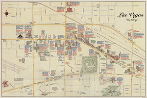
'This map compiled by General Drafting Service to show purchases in the Las Vegas area by Howard Hughes and others reported to be affiliated with him.' Shows land owned by Howard Hughes and land owned by Hughes Tool Company. Includes locations of casinos on Las Vegas Strip. Original publisher: General Drafting Service. Scale [ca. 1:48,000]. 1 in. to 4,000 feet. Hand-colored.
Image